Difference between revisions of "2008-11-15 49 8"
imported>Ryo m |
imported>FippeBot m (Location) |
||
| (7 intermediate revisions by one other user not shown) | |||
| Line 15: | Line 15: | ||
'''Planning:''' [[User:Moe|Moe]] and me, did plan this as a midnight hash. We also where out for some hiking in the forest, and before that, we wanted to locate a Geocache in Neuleinigen(Pfalz). | '''Planning:''' [[User:Moe|Moe]] and me, did plan this as a midnight hash. We also where out for some hiking in the forest, and before that, we wanted to locate a Geocache in Neuleinigen(Pfalz). | ||
| − | '''Expedition:''' First we did a nice Cache in Neuleinigen. That took as about 30 minutes. Then at about 20:45 we drove to Battenberg and started walking from the Waldstraße directly in the forest. It was already very dark. It took us 3.05 km to the hash, which was hard to reach. We had no map of that area, causing us to walk back and forth to searching for hiking trails. We gave up on finding the right one, and climbed right up through the forest and found the hiking trail. That didn't help us, we already were on the point where we had to | + | '''Expedition:''' First we did a [http://www.geocaching.com/seek/cache_details.aspx?guid=3f8ebc38-a271-448b-8075-8a58253aa2d2 real nice Cache in Neuleinigen], which made a lot of fun. That took as about 30 minutes. Then at about 20:45 we drove to Battenberg and started walking from the Waldstraße directly in the forest. It was already very dark.<br><br> |
| + | It took us 3.05 km to the hash, which was hard to reach. We had no map of that area, causing us to walk back and forth to searching for hiking trails. We gave up on finding the right one, and climbed right up through the forest and found the hiking trail. That didn't help us, we already were on the point where we had to leave the track anyway to reach the hash. Only 345m high but rampant. We instantly took the photos, and waited for midnight, while we eat something, with soy sausages, fruits, chips, coffee and cookies. I missed to take a tablecloth with us, so I can not call that a picnic.<br><br> | ||
| + | After that we took the correct trail back to the car, which lead us going up and down. I felt not very good, because I was already sick, and it was very stressful for me. Is there a "Sick achievement"? :)<br><br> | ||
| − | + | <gallery> | |
| − | + | Image:2008-11-15_gps1.jpg|Coordinates. Sorry for the bad quality | |
| − | + | Image:2008-11-15_gps2.jpg|Date & more | |
| − | + | Image:2008-11-15_ryo.jpg|It's me Ryo. Did not modify. Rotate yourself :)] | |
| − | + | Image:2008-11-15_picnic.jpg|Nom nom... Check Time. Date was set apparently wrong on the camera. We missed to shoot a watch. Sorry. | |
| + | </gallery> | ||
<br> | <br> | ||
| − | {{Midnight geohash | latitude = 49 | longitude = 8 | date = | + | {{Midnight geohash | latitude = 49 | longitude = 8 | date = 2008-11-15 | name = [[User:Ryo|Ryo]]}}{{land geohash | latitude = 49 | longitude = 8 | date = 2008-11-15 | name = [[User:Ryo|Ryo]]}} |
[[Category:Expeditions]] | [[Category:Expeditions]] | ||
[[Category:Expeditions with photos]] | [[Category:Expeditions with photos]] | ||
[[Category:Coordinates reached]] | [[Category:Coordinates reached]] | ||
| − | [[Category: | + | [[Category:Ryo]] |
| + | {{location|DE|RP|DÜW}} | ||
Latest revision as of 13:00, 28 July 2019
| Sat 15 Nov 2008 in Mannheim: 49.5220956, 8.1288515 geohashing.info google osm bing/os kml crox |
Location
This hashpoint was located in the forest near Battenberg(Pfalz). It was not that easy to reach. You had to walk through the forest, and you need to leave the hiking trail to reach the hash. It was mountained, and you nearly have to climb on some locations. Altitude of hash was 345m.
Expedition
Ryo
Planning: Moe and me, did plan this as a midnight hash. We also where out for some hiking in the forest, and before that, we wanted to locate a Geocache in Neuleinigen(Pfalz).
Expedition: First we did a real nice Cache in Neuleinigen, which made a lot of fun. That took as about 30 minutes. Then at about 20:45 we drove to Battenberg and started walking from the Waldstraße directly in the forest. It was already very dark.
It took us 3.05 km to the hash, which was hard to reach. We had no map of that area, causing us to walk back and forth to searching for hiking trails. We gave up on finding the right one, and climbed right up through the forest and found the hiking trail. That didn't help us, we already were on the point where we had to leave the track anyway to reach the hash. Only 345m high but rampant. We instantly took the photos, and waited for midnight, while we eat something, with soy sausages, fruits, chips, coffee and cookies. I missed to take a tablecloth with us, so I can not call that a picnic.
After that we took the correct trail back to the car, which lead us going up and down. I felt not very good, because I was already sick, and it was very stressful for me. Is there a "Sick achievement"? :)

Coordinates. Sorry for the bad quality

Date & more
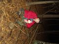
It's me Ryo. Did not modify. Rotate yourself :)]
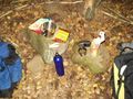
Nom nom... Check Time. Date was set apparently wrong on the camera. We missed to shoot a watch. Sorry.


Ryo earned the Midnight Geohash achievement
|
Ryo earned the Land geohash achievement
|