Difference between revisions of "2008-12-06 40 -75"
imported>Rseasmith |
m (fix, sorry) |
||
| (4 intermediate revisions by 4 users not shown) | |||
| Line 2: | Line 2: | ||
| map=<map lat="40" lon="-75" date="2008-12-06" /> | | map=<map lat="40" lon="-75" date="2008-12-06" /> | ||
| lat=40 | | lat=40 | ||
| − | | lon=- | + | | lon=-75 |
| date=2008-12-06 | | date=2008-12-06 | ||
| graticule_name=Allentown | | graticule_name=Allentown | ||
| Line 14: | Line 14: | ||
==Expedition== | ==Expedition== | ||
| − | The hash was located | + | The hash was located {{egl|2008-12-06|40|-76|text=here}}. |
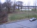
It was located in someone's back yard, and the nearby road wasn't conducive to parking, so I drove around looking for a better spot. Luckily, directly behind the hash point was a large industrial building where tractor trailers would unload cargo. I wasn't sure if I could park there, but it didn't exactly seem to be a hot spot of activity on a Saturday afternoon (See pictures below). | It was located in someone's back yard, and the nearby road wasn't conducive to parking, so I drove around looking for a better spot. Luckily, directly behind the hash point was a large industrial building where tractor trailers would unload cargo. I wasn't sure if I could park there, but it didn't exactly seem to be a hot spot of activity on a Saturday afternoon (See pictures below). | ||
| Line 32: | Line 32: | ||
Image:2008_12_06_40_-75_exspences.JPG|If my car got towed I'd have to pay "exspences" | Image:2008_12_06_40_-75_exspences.JPG|If my car got towed I'd have to pay "exspences" | ||
Image:2008_12_06_40_-75_power_lines.JPG|Sign about low power lines | Image:2008_12_06_40_-75_power_lines.JPG|Sign about low power lines | ||
| − | Image:2008_12_06_40_-75_ladder.JPG|The ladder I climbed up against | + | Image:2008_12_06_40_-75_ladder.JPG|The ladder I climbed up against my better judgment |
Image:2008_12_06_40_-75_on_roof1.JPG|Looking at the hash on the roof | Image:2008_12_06_40_-75_on_roof1.JPG|Looking at the hash on the roof | ||
Image:2008_12_06_40_-75_on_roof2.JPG|Looking at the roof | Image:2008_12_06_40_-75_on_roof2.JPG|Looking at the roof | ||
</gallery> | </gallery> | ||
| − | |||
[[Category:Expeditions]] | [[Category:Expeditions]] | ||
[[Category:Expeditions with photos]] | [[Category:Expeditions with photos]] | ||
[[Category:Coordinates not reached]] | [[Category:Coordinates not reached]] | ||
| − | [[Category: | + | [[Category:Not reached - No public access]] |
| + | {{location|US|PA|NA}} | ||
Latest revision as of 18:54, 18 January 2022
| Sat 6 Dec 2008 in Allentown: 40.7112022, -75.3223535 geohashing.info google osm bing/os kml crox |
About
Only rseasmith showed up, and he could only get within 269 feet of the hash. Explanation below.
Expedition
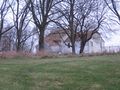
The hash was located here.
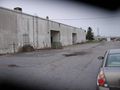
It was located in someone's back yard, and the nearby road wasn't conducive to parking, so I drove around looking for a better spot. Luckily, directly behind the hash point was a large industrial building where tractor trailers would unload cargo. I wasn't sure if I could park there, but it didn't exactly seem to be a hot spot of activity on a Saturday afternoon (See pictures below).
I parked my car as close as I felt like going. I waited around for a while and decided if I couldn't get to the hash point I might as well explore the surrounding area. The industrial building had a metal ladder going up to the roof, and (against my better judgment) I climbed up to the top of it to explore the roof. There wasn't anything up there except for gravel and exhaust ducts.
After I snapped some photos, I decided I better leave the area in case someone saw me on top of the building and called the police (doubtful, but I'm paranoid like that). It was 4:20 when I left and I figured no one else was going to show up. I drove by the hash point one more time on my way back and no one was there.
In total, it was an exciting day. I climbed on top of a building and saw some really desolate farm land.
Gallery
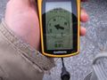
I got pretty close...
...but didn't want to get closer
Where I parked my car and my lens cover didn't open all the way
If my car got towed I'd have to pay "exspences"
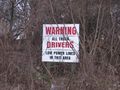
Sign about low power lines
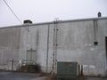
The ladder I climbed up against my better judgment
Looking at the hash on the roof
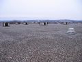
Looking at the roof


