Difference between revisions of "2008-12-13 50 9"
imported>Danatar (story will follow, probably on Monday) |
imported>FippeBot m (Location) |
||
| (One intermediate revision by one other user not shown) | |||
| Line 9: | Line 9: | ||
== Location == | == Location == | ||
| − | Today's location is in the forest in the Homburg ruin nature reserve near Gössenheim and Karsbach, not far from Karlstadt am Main. | + | Today's location is in the forest in the Homburg castle ruin nature reserve near Gössenheim and Karsbach, not far from Karlstadt am Main. |
| Line 15: | Line 15: | ||
===[[User:Danatar|Danatar]]=== | ===[[User:Danatar|Danatar]]=== | ||
| − | coordinates | + | I had a car for this expedition because I have to fetch the car's owner from Frankfurt airport tomorrow, otherwise the hashpoint would be out of reach this time of the year. I started at 15 o'clock and did not leave the B27 highway from where the car was parked until Gössenheim. Then I took a small road until I reached the Homburg castle ruin nature reserve's parking lot at 15:40. The rest of the way I went on foot along the fields and forest tracks, jogged the last part to save time and arrived near the hashpoint at 16:04. Then I started watching the display of the car's navigation system, going one step ahead / two steps back / three steps to the right <s>and cha-cha-cha</s> all the time. When after about 15 minutes the exact coordinates had not shown up (but every other coordinate had), I went back to the car. I arrived back home at about 17:30 in total darkness. |
| + | |||
| + | |||
| + | I walked about 4.5 km, distance by car was 75 km. | ||
<gallery> | <gallery> | ||
| − | + | Image:2008-12-13 50 9 1goessenheim.jpg|Gössenheim town sign | |
| + | Image:2008-12-13 50 9 2naturschutz.jpg|Homburg castle ruin nature reserve, with rare bats. Homburg castle built in 1018, in decay since about 1680. | ||
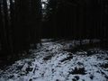
| + | Image:2008-12-13 50 9 3track.jpg|The hashpoint is getting nearer | ||
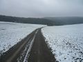
| + | Image:2008-12-13 50 9 4overview.jpg|Around the hashpoint are tire tracks from forest machines | ||
| + | Image:2008-12-13 50 9 5hp.jpg|Coordinates reached. I don't know where exactly, but I trampled everything in reach | ||
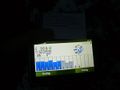
| + | Image:2008-12-13 50 9 gps-sec.jpg|In degree-minutes-seconds mode the hashpoint was quickly found... | ||
| + | Image:2008-12-13 50 9 gps.jpg|...but in degree mode it was a little more difficult. GPS is still on daylight saving time. | ||
</gallery> | </gallery> | ||
| Line 26: | Line 35: | ||
[[Category:Coordinates reached]] | [[Category:Coordinates reached]] | ||
[[Category:Danatar]] | [[Category:Danatar]] | ||
| + | {{location|DE|BY|MSP}} | ||
Latest revision as of 01:01, 8 August 2019
| Sat 13 Dec 2008 in Fulda: 50.0352845, 9.8161160 geohashing.info google osm bing/os kml crox |
Location
Today's location is in the forest in the Homburg castle ruin nature reserve near Gössenheim and Karsbach, not far from Karlstadt am Main.
Expedition
Danatar
I had a car for this expedition because I have to fetch the car's owner from Frankfurt airport tomorrow, otherwise the hashpoint would be out of reach this time of the year. I started at 15 o'clock and did not leave the B27 highway from where the car was parked until Gössenheim. Then I took a small road until I reached the Homburg castle ruin nature reserve's parking lot at 15:40. The rest of the way I went on foot along the fields and forest tracks, jogged the last part to save time and arrived near the hashpoint at 16:04. Then I started watching the display of the car's navigation system, going one step ahead / two steps back / three steps to the right and cha-cha-cha all the time. When after about 15 minutes the exact coordinates had not shown up (but every other coordinate had), I went back to the car. I arrived back home at about 17:30 in total darkness.
I walked about 4.5 km, distance by car was 75 km.

Gössenheim town sign
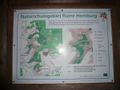
Homburg castle ruin nature reserve, with rare bats. Homburg castle built in 1018, in decay since about 1680.
The hashpoint is getting nearer
Around the hashpoint are tire tracks from forest machines

Coordinates reached. I don't know where exactly, but I trampled everything in reach
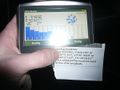
In degree-minutes-seconds mode the hashpoint was quickly found...
...but in degree mode it was a little more difficult. GPS is still on daylight saving time.


