2008-12-27 51 8
| Sat 27 Dec 2008 in 51,8: 51.5988770, 8.0776342 geohashing.info google osm bing/os kml crox |
About
The hash was located on the western side of the Paderborn-graticule, few kilometers from the town Soest, which features a nice old town, which we didn't visit today. More exactly, the hash was to be found on a ... surprise! ... acre in the hamlet of Meckingsen.
Participants
- lyx
- lyx's sister
Expedition
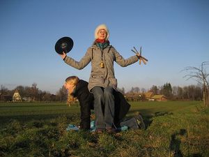
We took the car from our parents' home in Hamm and drove through the flat landscape shone upon by a low winter sun. We saw wild geese resting on the floodplains of river Lippe (those brown dots on the foto). After some interesting transposition manoeuvres, relying on the frozen ground beside the small streets, we parked the car at Meckingsen, Milchstraße. The literal translation of "Milchstraße" is Milk Street, which is what we call the Milky Way. From there we walked back to the Endloser Weg (engl.: Endless Street), and we were happy that we had decided not to go by train and walk all that way because a freezing wind was blowing. As the ground was frozen, we could walk on the field without damaging the grass (?) growing on it. (Picture of exact coordinates reached follows.) On the side of the field we posed in commemoration of Oslo. (German speaking readers may understand why we used rasps for arrows - Feile ("rasps") is pronounced almost the same as Pfeile ("arrows").)
