Difference between revisions of "2009-01-10 37 -122"
imported>Darcy (→The Meetup) |
imported>FippeBot m (Location) |
||
| (4 intermediate revisions by 3 users not shown) | |||
| Line 9: | Line 9: | ||
==The Meetup== | ==The Meetup== | ||
| + | [[image:Eightexplorers.JPG|thumb|Eight intrepid explorers]] | ||
| + | [[image:011009proof.JPG|thumb|The internet was here]] | ||
| + | [[image:Movingcoordinates.JPG|thumb|Teleportation the old-fashioned way]] | ||
| + | [[image:Headoncar.jpg|thumb|On our way to the park we encountered a mildly strange sight (particularly mild for Berkeley)]] | ||
| + | [[image:Headcloseup.jpg|thumb|Susan B. Anthony, the Colossus of Berkeley]] | ||
| + | |||
"Once upon a time, eight intrepid explorers converged on a spot in the mysterious forest of the City of Berkeley..." ...or so David's opening round of Once Upon A Time began. | "Once upon a time, eight intrepid explorers converged on a spot in the mysterious forest of the City of Berkeley..." ...or so David's opening round of Once Upon A Time began. | ||
| Line 22: | Line 28: | ||
*Martha | *Martha | ||
| − | Darcy and Megan | + | {{bicycle geohash | latitude = 37 | longitude = -122 | date = 2009-01-10 | name = Darcy and Megan | image = Leavingproof.JPG}} |
| + | |||
| + | Although none of us had actually brought a GPS, several of us checked Google Maps on our phones and established that the white line visible in the satellite view was the white balustrade next to the steps: | ||
| + | |||
| + | [[image:Geohash-with-feet.jpg|Now that's what I call a good level of zoom!]] | ||
After about half an hour noodling around the actual geohash, we left a piece of paper explaining that 37.865958 -122.279772 had been relocated to a park at California and Delaware (about six blocks/half a mile north). Since we left the paper anchored in the mouth of a trash can, we're hoping it ''did'' become rubbish after we left! | After about half an hour noodling around the actual geohash, we left a piece of paper explaining that 37.865958 -122.279772 had been relocated to a park at California and Delaware (about six blocks/half a mile north). Since we left the paper anchored in the mouth of a trash can, we're hoping it ''did'' become rubbish after we left! | ||
| + | |||
| + | <gallery perrow="3"> | ||
| + | image:SF_Geohashers_01-10-09.jpg|Eight Intrepid Explorers (minus the photographer) | ||
| + | image:Leavingproof.JPG|Proof, picnic foods, (p)bicycles | ||
| + | image:Serioushashers.JPG|So very serious, especially with that ukelele | ||
| + | </gallery> | ||
| + | |||
At the park, we ate bread and cheese and apple (provided by Ping and David) and played a couple rounds of Once Upon A Time. Then the sun went down, and we went across the street to the house of Pier's friend who by sheer coincidence of the universe (or at least of the stock market) was hosting a board game afternoon. | At the park, we ate bread and cheese and apple (provided by Ping and David) and played a couple rounds of Once Upon A Time. Then the sun went down, and we went across the street to the house of Pier's friend who by sheer coincidence of the universe (or at least of the stock market) was hosting a board game afternoon. | ||
| − | {{ | + | {{Picnic |
| latitude = 37 | | latitude = 37 | ||
| Line 35: | Line 52: | ||
| name = Seven intrepid explorers (we lost one, possibly to an ogre from another kingdom) | | name = Seven intrepid explorers (we lost one, possibly to an ogre from another kingdom) | ||
| food = bread (from [http://www.bread-workshop.com/ The Bread Workshop]), swiss cheese, and apple | | food = bread (from [http://www.bread-workshop.com/ The Bread Workshop]), swiss cheese, and apple | ||
| − | }} | + | }} |
| − | |||
| − | |||
| − | |||
| − | |||
| − | |||
| − | |||
| − | |||
| − | |||
| − | |||
| − | |||
==Planning Info== | ==Planning Info== | ||
| Line 53: | Line 60: | ||
*[[User:Treiza|Treiza]] says: Just joined, and I'll be there! ''and'' A friend of mine is having people over to play games just a few blocks away that day, actually. All xkcd-type folks... perhaps I'll try to drag a few along. We can adjourn there, if anyone else is interested. | *[[User:Treiza|Treiza]] says: Just joined, and I'll be there! ''and'' A friend of mine is having people over to play games just a few blocks away that day, actually. All xkcd-type folks... perhaps I'll try to drag a few along. We can adjourn there, if anyone else is interested. | ||
*Elizabeth says: Oh hey, I could stop by that one too. But not until 5:30 at the earliest (I'll be at work until 5:15). | *Elizabeth says: Oh hey, I could stop by that one too. But not until 5:30 at the earliest (I'll be at work until 5:15). | ||
| + | |||
| + | |||
| + | [[Category:Expeditions]] | ||
| + | [[Category:Expeditions with photos]] | ||
| + | [[Category:Coordinates reached]] | ||
| + | {{location|US|CA|AA}} | ||
Latest revision as of 01:19, 8 August 2019
| Sat 10 Jan 2009 in San Francisco, California: 37.8659580, -122.2797711 geohashing.info google osm bing/os kml crox |
On Bancroft Way in Berkeley, between California and Spaulding.
The Meetup


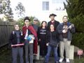
"Once upon a time, eight intrepid explorers converged on a spot in the mysterious forest of the City of Berkeley..." ...or so David's opening round of Once Upon A Time began.
The eight intrepid explorers were (apologies for name misspellings):
- Darcy
- Ping
- David
- Indy
- Megan
- Pier
- Jim
- Martha
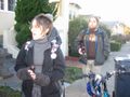
Darcy and Megan earned the Bicycle geohash achievement
|
Although none of us had actually brought a GPS, several of us checked Google Maps on our phones and established that the white line visible in the satellite view was the white balustrade next to the steps:

After about half an hour noodling around the actual geohash, we left a piece of paper explaining that 37.865958 -122.279772 had been relocated to a park at California and Delaware (about six blocks/half a mile north). Since we left the paper anchored in the mouth of a trash can, we're hoping it did become rubbish after we left!
Eight Intrepid Explorers (minus the photographer)
Proof, picnic foods, (p)bicycles
So very serious, especially with that ukelele


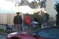
At the park, we ate bread and cheese and apple (provided by Ping and David) and played a couple rounds of Once Upon A Time. Then the sun went down, and we went across the street to the house of Pier's friend who by sheer coincidence of the universe (or at least of the stock market) was hosting a board game afternoon.
Seven intrepid explorers (we lost one, possibly to an ogre from another kingdom) earned the Picnic achievement
|
Planning Info
(Copied from the googlegroup)
- Darcy says: I'll totally be at the Saturday SF/Berkeley spot!
- Treiza says: Just joined, and I'll be there! and A friend of mine is having people over to play games just a few blocks away that day, actually. All xkcd-type folks... perhaps I'll try to drag a few along. We can adjourn there, if anyone else is interested.
- Elizabeth says: Oh hey, I could stop by that one too. But not until 5:30 at the earliest (I'll be at work until 5:15).