Difference between revisions of "2009-01-14 35 -77"
From Geohashing
imported>Ncbears (→Pictures) |
imported>Ncbears (→Pictures) |
||
| Line 33: | Line 33: | ||
Image:01_14_09_Walk_back_to_Truck_012.jpg|Walk back to truck | Image:01_14_09_Walk_back_to_Truck_012.jpg|Walk back to truck | ||
Image:01_14_09_Wild_life_near_Geohash_013.jpg|Sign of wild life near Geohash | Image:01_14_09_Wild_life_near_Geohash_013.jpg|Sign of wild life near Geohash | ||
| + | Image:Goggle_Earth_Screenprint_01_14_09.JPG|Google Earth screenprint | ||
</gallery> | </gallery> | ||
Revision as of 01:19, 15 January 2009
| Wed 14 Jan 2009 in 35,-77: 35.8578152, -77.8131697 geohashing.info google osm bing/os kml crox |
Report
Participants
Eisen & Bear - NCBears
Geological Features
Level farmland. Outskirts of large town. Geohash was located ~17 meters in crop field. See Google Earth screenshot below.
Wildlife Encounters
- See picture below of wild-life signs
Weather
33°F/0.6°C, clear skies
Pictures
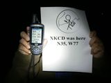
NCBears at N35 W77 Geohash

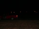
Dark field
Walk back to truck

Sign of wild life near Geohash
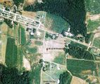
Google Earth screenprint


Achievements
- NCBearsxkcdregion3.png

