Difference between revisions of "2009-01-25 30 -81"
imported>FippeBot m (Location) |
|||
| (9 intermediate revisions by 4 users not shown) | |||
| Line 16: | Line 16: | ||
=== The Chase === | === The Chase === | ||
| − | For the second consecutive weekend Mr. Bow Tie | + | For the second consecutive weekend [[user:Woodveil|Woodveil]] and [[user:Mr. Bow Tie|Mr. Bow Tie]] are attempting a hash. This week's hash was mysteriously close to [[2009-01-18 30 -81|last week's]]. Coincidence? Probably. Anyway, we thought we would have a relatively easy hash so long as there were not any "No Trespassing" signs. The hash itself was in a wooded area between Jacksonville and St. Augustine. We set off around 10am from Orange Park hoping to get there for an 11am meet-up. |
| + | |||
| + | We intended to use google-maps to get us to within walking distance and according to google we would be able to get within 600m of the point with the car. Alas, technology is not perfect and northeast Florida is booming as far as construction and new development is concerned. Simply put, the map lied. Not once, not twice, not three times, but four times we encountered roadblocks on our way to the hash. Roads that for one reason or another someone did not want us to traverse. On our fifth attempt, we got as close as could (1.23km) and set out on foot. | ||
| + | |||
| + | We used an existing path to get us to about 878m from the point. The trail continued on, but in the wrong direction, so we set off into the wilderness. The dense brush made progress slow. Progress was also hampered by our constant looking for dangerous animal and plant life, which included, but was not limited to: poison ivy, poison oak, poisonous snakes and spiders, raccoons, bears, and velociraptors. | ||
| + | |||
| + | Just when we thought there was a chance of reaching the point we came upon one of the few things that would stop us in our tracks; a swamp. After an hour and a half of circumnavigating the hashpoint looking for roads that would get us close to it, and hiking trails both thick and thin, our adventure came to a disappointing end with 828m remaining. | ||
== Gallery == | == Gallery == | ||
<gallery caption="Photo Gallery" widths="200px" heights="200px" perrow="3"> | <gallery caption="Photo Gallery" widths="200px" heights="200px" perrow="3"> | ||
| − | Image:2009-01-25 ant.jpg | + | Image:2009-01-25 ant.jpg|Mr. Bow Tie without his bow tie. |
| − | Image:2009-01-25 block1.jpg | + | Image:2009-01-25 block1.jpg|Roadblock #1 |
| − | Image:2009-01-25 block2b.jpg | + | Image:2009-01-25 block2b.jpg|Dirt road that looked promising. |
| − | Image:2009-01-25 block2.jpg | + | Image:2009-01-25 block2.jpg|Block #2 |
| − | Image:2009-01-25 block3.jpg | + | Image:2009-01-25 block3.jpg|The blocking continues... |
| − | Image:2009-01-25 block4.jpg | + | Image:2009-01-25 block4.jpg|Really?!? 4 roadblocks. |
| − | Image:2009-01-25 | + | Image:2009-01-25 trail.jpg|The nice trail. |
| − | Image:2009-01-25 | + | Image:2009-01-25 woods.jpg|The dense woods. |
| − | Image:2009-01-25 tracks.jpg | + | Image:2009-01-25 tracks.jpg|Some deer tracks along the way. |
| − | Image:2009-01-25 swamp1.jpg | + | Image:2009-01-25 swamp1.jpg|Pseudoswamp. |
| − | Image:2009-01-25 swamp2.jpg | + | Image:2009-01-25 swamp2.jpg|Real swamp. |
| − | Image:2009-01-25 gps.jpg | + | Image:2009-01-25 gps.jpg|Our closest point. |
</gallery> | </gallery> | ||
| Line 38: | Line 44: | ||
== Achievements == | == Achievements == | ||
| − | {{There | + | {{There might be alligators! |
| latitude = 30 | | latitude = 30 | ||
| longitude = -81 | | longitude = -81 | ||
| − | | date = | + | | date = 2009-01-25 |
| − | | name = Mr. Bow Tie and Woodveil | + | | name = [[user:Mr. Bow Tie|Mr. Bow Tie]] and [[user:Woodveil|Woodveil]] |
| hazard = Classic Florida Swamp | | hazard = Classic Florida Swamp | ||
| image = 2009-01-25_swamp2.jpg | | image = 2009-01-25_swamp2.jpg | ||
| Line 50: | Line 56: | ||
[[Category:Expeditions with photos]] | [[Category:Expeditions with photos]] | ||
[[Category:Coordinates not reached]] | [[Category:Coordinates not reached]] | ||
| − | [[Category: | + | [[Category:Not reached - Mother Nature]] |
| + | {{location|US|FL|SJ}} | ||
Latest revision as of 01:32, 8 August 2019
| Sun 25 Jan 2009 in Jacksonville, Florida: 30.0374503, -81.4350494 geohashing.info google osm bing/os kml crox |
Expeditions
Geohashers in Attendance
The Chase
For the second consecutive weekend Woodveil and Mr. Bow Tie are attempting a hash. This week's hash was mysteriously close to last week's. Coincidence? Probably. Anyway, we thought we would have a relatively easy hash so long as there were not any "No Trespassing" signs. The hash itself was in a wooded area between Jacksonville and St. Augustine. We set off around 10am from Orange Park hoping to get there for an 11am meet-up.
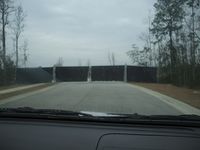
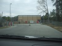
We intended to use google-maps to get us to within walking distance and according to google we would be able to get within 600m of the point with the car. Alas, technology is not perfect and northeast Florida is booming as far as construction and new development is concerned. Simply put, the map lied. Not once, not twice, not three times, but four times we encountered roadblocks on our way to the hash. Roads that for one reason or another someone did not want us to traverse. On our fifth attempt, we got as close as could (1.23km) and set out on foot.
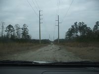
We used an existing path to get us to about 878m from the point. The trail continued on, but in the wrong direction, so we set off into the wilderness. The dense brush made progress slow. Progress was also hampered by our constant looking for dangerous animal and plant life, which included, but was not limited to: poison ivy, poison oak, poisonous snakes and spiders, raccoons, bears, and velociraptors.
Just when we thought there was a chance of reaching the point we came upon one of the few things that would stop us in our tracks; a swamp. After an hour and a half of circumnavigating the hashpoint looking for roads that would get us close to it, and hiking trails both thick and thin, our adventure came to a disappointing end with 828m remaining.
Gallery
- Photo Gallery
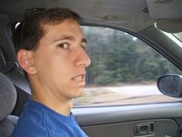
Mr. Bow Tie without his bow tie.
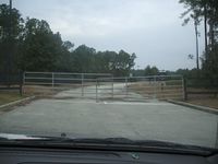
Roadblock #1
Dirt road that looked promising.
Block #2
The blocking continues...
Really?!? 4 roadblocks.
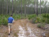
The nice trail.
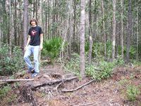
The dense woods.
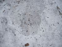
Some deer tracks along the way.
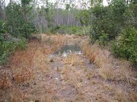
Pseudoswamp.
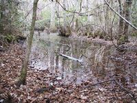
Real swamp.
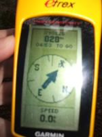
Our closest point.


Achievements
Mr. Bow Tie and Woodveil earned the There might be alligators! consolation prize
|