Difference between revisions of "2009-02-08 51 -1"
imported>Homsar (adding Expedition template) |
imported>FippeBot m (Location) |
||
| (9 intermediate revisions by 3 users not shown) | |||
| Line 1: | Line 1: | ||
| − | + | <!--[[Image:IMAGE|thumb|left]] not yet--> | |
| − | <!-- | ||
| − | [[Image:IMAGE|thumb|left]] | ||
{{meetup graticule | {{meetup graticule | ||
| − | | map=<map lat= | + | | map=<map lat=51 lon=-1 date=2009-02-08/> |
| − | | lat= | + | | lat=51 |
| − | | lon= | + | | lon=-1 |
| − | | date= | + | | date=2009-02-08 |
}} | }} | ||
<!-- edit as necessary --> | <!-- edit as necessary --> | ||
__NOTOC__ | __NOTOC__ | ||
| + | == About == | ||
| + | The hashpoint is a few metres off a road helpfully marked by Google as "Unknown road", which itself is only a few hundred metres away from the M40 (passing directly over the top of it but not intersecting; you'd have to exit at junction 8a and go round one way or the other). Google's walking directions say it's 3 hours walk from Oxford, so it's definitely cyclable from there. Traveline suggests that it'd be 62 minutes for a slow cyclist - although IME they're prone to underestimate such times. | ||
| + | |||
== Participants == | == Participants == | ||
| − | + | * [[User:Homsar|Homsar]] | |
== Plans == | == Plans == | ||
| − | + | * I'm planning on doing this one, probably in the afternoon. Cycling out from Oxford. [[User:Homsar|Homsar]] 23:22, 6 February 2009 (UTC) | |
== Expedition == | == Expedition == | ||
| + | Intended to set out at 11; ended up setting out shortly after 12 (due to washing up from a home-made pizza party) after a light brunch. Took a rucksack full of liquids, solids (and probably some gases as well), in addition to maps (since I don't have a GPS). It snowed quite heavily on Thursday night, and much of it had not yet melted. Exited Oxford with relative ease, although Queen's Lane was like cycling on freshly-greased glass due to the ice. A couple of wrong turns and regular map checks later I reached the Epic Hill Of Doom, which sadly looks lame and shallow on camera but was unbelievably steep in RL. I walked it. At the top of the Hill, I discovered Windmill Lane, which is "not suitable for motor vehicles". Luckily I wasn't using one, and it was treacherous enough on any means of transportation due to the large quantities of ice. I suspect that it had snowed here more recently, since much of the snow was lovely and fluffy (rather than melty or hardened like old snow tends to be), and also much of it was undisturbed. Having been stuck in the centre of Oxford through most of the (extremely unusual) snowy season, it was nice to be able to enjoy such vast amounts of beautiful snowy scenery, such a rare thing in this corner of the world. Anywho, from here getting to above the M40 was relatively painless, although some of the uphill bits were walked (as I've not done an 18-mile cycle anywhere before, let alone in hilly Oxfordshire on the world's heaviest bike). | ||
| + | Sadly the gate into the field in which the hashpoint was was closed, so walking straight in would have been trespassing. I carried on along the road to the house of the presumed owners (the garden has a gate into the field, which seems to be the only access to the field, so it's not a massive leap of logic). This had closed gates, a driveway longer than my college that was covered in undisturbed snow, and no cars. I decided that this was sufficiently unfriendly and scary that I didn't want to risk my dignity going inside, and that there was probably no one there anyway. I biked back down to as close to the hashpoint as I could get, and photographed myself and left a message in the snow, then cycled/walked back home. As I went down the Epic Hill Of Steepness (MUCH more fun on the way down) it started sleeting, and most of the way back it couldn't decide between light sleet and heavier snow. | ||
== Tracklog == | == Tracklog == | ||
| − | + | [http://local.google.co.uk/maps?f=d&source=s_d&saddr=ox2+6hs&daddr=51.745047,-1.134768+to:51.75524%C2%B0,+-1.103412%C2%B0&hl=en&geocode=%3B%3BFei4FQMdzCnv_w&mra=dpe&mrcr=0&mrsp=1&sz=15&via=1&dirflg=w&sll=51.749431,-1.122279&sspn=0.021069,0.038495&ie=UTF8&z=15 The route I ended up taking] (the manual route change in Wheatley was due to a wrong turn that I corrected by taking a slightly alternative route) <small>(I don't know how stable Google route links are)</small> | |
| + | [http://local.google.co.uk/maps?f=q&source=s_q&hl=en&geocode=&q=51.75524%C2%B0,+-1.103412%C2%B0&sll=51.754738,-1.102774&sspn=0.005267,0.009624&dirflg=w&ie=UTF8&ll=51.755067,-1.103195&spn=0.001317,0.002406&t=h&z=19 The hashpoint] (showing the elements referred to in the description) | ||
== Photos == | == Photos == | ||
<gallery perrow="3"> | <gallery perrow="3"> | ||
| − | Image:2009- | + | Image:2009-02-08 51,-1 01.jpg|Epic Hill looks wimpy here |
| − | Image:2009- | + | Image:2009-02-08 51,-1 03.jpg|"Unsuitable for motor vehicles" - or anyone with any common sense, at the moment |
| + | Image:2009-02-08 51,-1 24.jpg|Who'da thunk that Windmill Lane... | ||
| + | Image:2009-02-08 51,-1 23.jpg|...has a windmill?! | ||
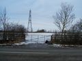
| + | Image:2009-02-08 51,-1 11.jpg|The gate on the opposing side of the road. The Google aerial view showed this, with a white road/track/footpath/something on the other side. Unfortunately this isn't distinctly visible here due to the large amounts of white there for other reasons. | ||
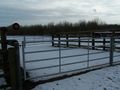
| + | Image:2009-02-08 51,-1 13.jpg|The forbidden gate, complete with bike and bag | ||
| + | Image:2009-02-08 51,-1 16.jpg|Townsend House, presumably home to the owners of the hashpoint, also with bike and bag | ||
| + | Image:2009-02-08 51,-1 18.jpg|I thought the door might give clues, but couldn't read it, so zoomed in. It turned out not to be worth the effort of fiddling with the focus settings. | ||
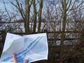
| + | Image:2009-02-08 51,-1 19.jpg|My aerial photo printout, as close to the haspoint as I could get (probably <5m). My guess is that the hashpoint is the point in the snow visible just above the top of the post next to the map. | ||
| + | Image:2009-02-08 51,-1 21.jpg|Me as close to the hashpoint as was practicable. I don't normally have a double chin, only when I'm in an awkward position trying to photograph myself as well as get some of the hedge in. | ||
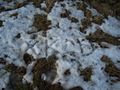
| + | Image:2009-02-08 51,-1 22.jpg|Spot the hidden message (snow is so much more convenient than rocks or sticks for temporary messages) | ||
</gallery> | </gallery> | ||
| − | |||
| − | |||
| − | |||
| − | |||
| − | |||
| − | |||
| − | |||
| − | |||
[[Category:Expeditions]] | [[Category:Expeditions]] | ||
[[Category:Expeditions with photos]] | [[Category:Expeditions with photos]] | ||
| − | |||
| − | |||
| − | |||
| − | |||
| − | |||
| − | |||
| − | |||
| − | |||
| − | |||
[[Category:Coordinates not reached]] | [[Category:Coordinates not reached]] | ||
| − | + | [[Category:Not reached - No public access]] | |
| − | + | {{location|GB|ENG|OXF}} | |
| − | [[Category: | ||
| − | |||
| − | |||
| − | |||
Latest revision as of 01:47, 8 August 2019
| Sun 8 Feb 2009 in 51,-1: 51.7552405, -1.1034115 geohashing.info google osm bing/os kml crox |
About
The hashpoint is a few metres off a road helpfully marked by Google as "Unknown road", which itself is only a few hundred metres away from the M40 (passing directly over the top of it but not intersecting; you'd have to exit at junction 8a and go round one way or the other). Google's walking directions say it's 3 hours walk from Oxford, so it's definitely cyclable from there. Traveline suggests that it'd be 62 minutes for a slow cyclist - although IME they're prone to underestimate such times.
Participants
Plans
- I'm planning on doing this one, probably in the afternoon. Cycling out from Oxford. Homsar 23:22, 6 February 2009 (UTC)
Expedition
Intended to set out at 11; ended up setting out shortly after 12 (due to washing up from a home-made pizza party) after a light brunch. Took a rucksack full of liquids, solids (and probably some gases as well), in addition to maps (since I don't have a GPS). It snowed quite heavily on Thursday night, and much of it had not yet melted. Exited Oxford with relative ease, although Queen's Lane was like cycling on freshly-greased glass due to the ice. A couple of wrong turns and regular map checks later I reached the Epic Hill Of Doom, which sadly looks lame and shallow on camera but was unbelievably steep in RL. I walked it. At the top of the Hill, I discovered Windmill Lane, which is "not suitable for motor vehicles". Luckily I wasn't using one, and it was treacherous enough on any means of transportation due to the large quantities of ice. I suspect that it had snowed here more recently, since much of the snow was lovely and fluffy (rather than melty or hardened like old snow tends to be), and also much of it was undisturbed. Having been stuck in the centre of Oxford through most of the (extremely unusual) snowy season, it was nice to be able to enjoy such vast amounts of beautiful snowy scenery, such a rare thing in this corner of the world. Anywho, from here getting to above the M40 was relatively painless, although some of the uphill bits were walked (as I've not done an 18-mile cycle anywhere before, let alone in hilly Oxfordshire on the world's heaviest bike).
Sadly the gate into the field in which the hashpoint was was closed, so walking straight in would have been trespassing. I carried on along the road to the house of the presumed owners (the garden has a gate into the field, which seems to be the only access to the field, so it's not a massive leap of logic). This had closed gates, a driveway longer than my college that was covered in undisturbed snow, and no cars. I decided that this was sufficiently unfriendly and scary that I didn't want to risk my dignity going inside, and that there was probably no one there anyway. I biked back down to as close to the hashpoint as I could get, and photographed myself and left a message in the snow, then cycled/walked back home. As I went down the Epic Hill Of Steepness (MUCH more fun on the way down) it started sleeting, and most of the way back it couldn't decide between light sleet and heavier snow.
Tracklog
The route I ended up taking (the manual route change in Wheatley was due to a wrong turn that I corrected by taking a slightly alternative route) (I don't know how stable Google route links are) The hashpoint (showing the elements referred to in the description)
Photos
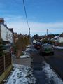
Epic Hill looks wimpy here
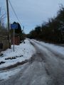
"Unsuitable for motor vehicles" - or anyone with any common sense, at the moment
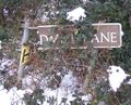
Who'da thunk that Windmill Lane...
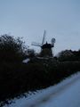
...has a windmill?!
The gate on the opposing side of the road. The Google aerial view showed this, with a white road/track/footpath/something on the other side. Unfortunately this isn't distinctly visible here due to the large amounts of white there for other reasons.
The forbidden gate, complete with bike and bag
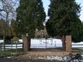
Townsend House, presumably home to the owners of the hashpoint, also with bike and bag
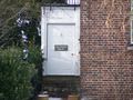
I thought the door might give clues, but couldn't read it, so zoomed in. It turned out not to be worth the effort of fiddling with the focus settings.
My aerial photo printout, as close to the haspoint as I could get (probably <5m). My guess is that the hashpoint is the point in the snow visible just above the top of the post next to the map.

Me as close to the hashpoint as was practicable. I don't normally have a double chin, only when I'm in an awkward position trying to photograph myself as well as get some of the hedge in.
Spot the hidden message (snow is so much more convenient than rocks or sticks for temporary messages)


