Difference between revisions of "2009-03-14 31 -111"
imported>FippeBot m (Location) |
m |
||
| Line 6: | Line 6: | ||
| graticule_name=Sasabe | | graticule_name=Sasabe | ||
| graticule_link=Sasabe, Arizona}} | | graticule_link=Sasabe, Arizona}} | ||
| + | ==Participants== | ||
| + | *[[User:Wyle & RoadRunner|Wyle & RoadRunner]] | ||
== Expeditions == | == Expeditions == | ||
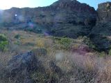
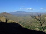
Our most adventureous geohash yet. We started with a 40 mile drive on the highway, quickly followed by a 4 wheel drive jeep trail that actually required 4x4. We came across a gate and I feared it would be locked and I would be forced to drive in reverse, uphill and in 4WD since there was NO room to turn around. Fortunately, there was no lock and we finished the 2 mile drive and started the 2 mile hike. We got to the point where the hash point was off the beaten path and had to bushwack 1/4 mile up the steep side of the mountain. Thank goodness the location was just short of the cliff faces. Made it after a bit of work and I surprised RoadRunner by breaking out the wine, glasses, pastrami, cheese and trail mix. She was wondering why I was taking my pack all the way up the hill. What a magnificent view. Salute. | Our most adventureous geohash yet. We started with a 40 mile drive on the highway, quickly followed by a 4 wheel drive jeep trail that actually required 4x4. We came across a gate and I feared it would be locked and I would be forced to drive in reverse, uphill and in 4WD since there was NO room to turn around. Fortunately, there was no lock and we finished the 2 mile drive and started the 2 mile hike. We got to the point where the hash point was off the beaten path and had to bushwack 1/4 mile up the steep side of the mountain. Thank goodness the location was just short of the cliff faces. Made it after a bit of work and I surprised RoadRunner by breaking out the wine, glasses, pastrami, cheese and trail mix. She was wondering why I was taking my pack all the way up the hill. What a magnificent view. Salute. | ||
Latest revision as of 17:16, 19 March 2022
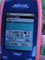
| Sat 14 Mar 2009 in Sasabe: 31.5407367, -111.1119046 geohashing.info google osm bing/os kml crox |
Participants
Expeditions
Our most adventureous geohash yet. We started with a 40 mile drive on the highway, quickly followed by a 4 wheel drive jeep trail that actually required 4x4. We came across a gate and I feared it would be locked and I would be forced to drive in reverse, uphill and in 4WD since there was NO room to turn around. Fortunately, there was no lock and we finished the 2 mile drive and started the 2 mile hike. We got to the point where the hash point was off the beaten path and had to bushwack 1/4 mile up the steep side of the mountain. Thank goodness the location was just short of the cliff faces. Made it after a bit of work and I surprised RoadRunner by breaking out the wine, glasses, pastrami, cheese and trail mix. She was wondering why I was taking my pack all the way up the hill. What a magnificent view. Salute.
Sasabe, Arizona
Sasabe, Arizona
Sasabe, Arizona


