Difference between revisions of "2009-04-03 53 9"
imported>Alingex |
imported>FippeBot m (Location) |
||
| (4 intermediate revisions by 2 users not shown) | |||
| Line 23: | Line 23: | ||
The first part of our tour went by without any problems, but then, perhaps 10km away from the geohash, our navigation suddenly stopped working. Fortunately, we still remembered some of the streets names, so we tried to reconstruct the way from memory. Then we used the satellite picture to find our field. When we arrived there, our efforts had taken so much time that it was 1 am already. Too bad about our Midnight Geohash... | The first part of our tour went by without any problems, but then, perhaps 10km away from the geohash, our navigation suddenly stopped working. Fortunately, we still remembered some of the streets names, so we tried to reconstruct the way from memory. Then we used the satellite picture to find our field. When we arrived there, our efforts had taken so much time that it was 1 am already. Too bad about our Midnight Geohash... | ||
Then we discovered that what we had expected to be trails were ditches instead, so we had to jump several times. And then the greatest problem occured: Our GPS software is just not made for geohashing. It took us almost one hour walking across the field to find the geohash, because the coordinates kept fluctuating - but in the end we did it. We stayed another 30 minutes for a little picnic, looked up to the beautiful sky and then returned home, where we arrived at 5 am. That really was an adventure! | Then we discovered that what we had expected to be trails were ditches instead, so we had to jump several times. And then the greatest problem occured: Our GPS software is just not made for geohashing. It took us almost one hour walking across the field to find the geohash, because the coordinates kept fluctuating - but in the end we did it. We stayed another 30 minutes for a little picnic, looked up to the beautiful sky and then returned home, where we arrived at 5 am. That really was an adventure! | ||
| − | |||
| − | |||
== Photos == | == Photos == | ||
<gallery perrow="3"> | <gallery perrow="3"> | ||
| − | Image: | + | Image:geohash2_2009-04-03_53_9.jpg | Obligatory smile |
| − | Image: | + | Image:geohash3_2009-04-03_53_9.jpg | Proof |
</gallery> | </gallery> | ||
| − | + | == Achievements == | |
| − | + | ||
| − | + | {{land geohash | |
| − | + | ||
| + | | latitude = 53 | ||
| + | | longitude = 9 | ||
| + | | date = 2009-04-03 | ||
| + | | name = Alex and Ingo | ||
| + | |||
| + | }} | ||
| + | {{Bicycle geohash | ||
| + | |||
| + | | latitude = 53 | ||
| + | | longitude = 9 | ||
| + | | date = 2009-04-03 | ||
| + | | name = Alex and Ingo | ||
| + | |||
| + | }} | ||
| + | |||
| + | |||
| − | |||
[[Category:Expeditions]] | [[Category:Expeditions]] | ||
| − | |||
| − | |||
| − | |||
| − | |||
| − | |||
| − | |||
| − | |||
| − | |||
[[Category:Coordinates reached]] | [[Category:Coordinates reached]] | ||
| − | + | {{location|DE|NI|ROW}} | |
| − | |||
| − | |||
| − | |||
| − | |||
| − | |||
| − | |||
| − | |||
| − | |||
| − | |||
Latest revision as of 02:36, 8 August 2019

| Fri 3 Apr 2009 in 53,9: 53.1842062, 9.1462521 geohashing.info google osm bing/os kml crox |
Participants
Alex, Ingo
Description
The geohash is located on a field near the village Vorwerk.
Expedition
April, 2nd - 10pm: Ingo and Alex spontaneously decide to visit their first geohash. The plan: Trying to reach the Hamburg graticule geohash by bike within the next 2 hours, so we could not only collect the Land Geohash and Bicycle Geohash, but also the Midnight Geohash. We were lucky the weather was just great, not too cold and no rain, and so we started our attempt using an Orbit1-Xda-GPS with navigation software. We also had a screenshot of the google maps satellite picture showing the geohashs location, but we didn't think we would need it.
The first part of our tour went by without any problems, but then, perhaps 10km away from the geohash, our navigation suddenly stopped working. Fortunately, we still remembered some of the streets names, so we tried to reconstruct the way from memory. Then we used the satellite picture to find our field. When we arrived there, our efforts had taken so much time that it was 1 am already. Too bad about our Midnight Geohash... Then we discovered that what we had expected to be trails were ditches instead, so we had to jump several times. And then the greatest problem occured: Our GPS software is just not made for geohashing. It took us almost one hour walking across the field to find the geohash, because the coordinates kept fluctuating - but in the end we did it. We stayed another 30 minutes for a little picnic, looked up to the beautiful sky and then returned home, where we arrived at 5 am. That really was an adventure!
Photos
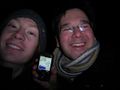
Obligatory smile
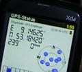
Proof


Achievements
Alex and Ingo earned the Land geohash achievement
|
Alex and Ingo earned the Bicycle geohash achievement
|