Difference between revisions of "2009-04-05 31 -110"
From Geohashing
imported>FippeBot m (Location) |
m |
||
| Line 6: | Line 6: | ||
| graticule_name=Nogales | | graticule_name=Nogales | ||
| graticule_link=Nogales, Arizona}} | | graticule_link=Nogales, Arizona}} | ||
| + | ==Participants== | ||
| + | *[[User:Wyle & RoadRunner|Wyle & RoadRunner]] | ||
== Expeditions == | == Expeditions == | ||
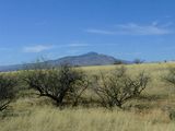
County line that is. We actually crossed it 4 times trying to find an access route. The easy jeep trail was gated and locked, but cunning RoadRunner found an alternate access location. Cows off in the distance, jack rabbits scattering everywhere and a curious line of rocks which remain a mystery. A new fruity wine for the celebration. | County line that is. We actually crossed it 4 times trying to find an access route. The easy jeep trail was gated and locked, but cunning RoadRunner found an alternate access location. Cows off in the distance, jack rabbits scattering everywhere and a curious line of rocks which remain a mystery. A new fruity wine for the celebration. | ||
Latest revision as of 17:14, 19 March 2022
| Sun 5 Apr 2009 in Nogales: 31.9456290, -110.4622726 geohashing.info google osm bing/os kml crox |
Participants
Expeditions
County line that is. We actually crossed it 4 times trying to find an access route. The easy jeep trail was gated and locked, but cunning RoadRunner found an alternate access location. Cows off in the distance, jack rabbits scattering everywhere and a curious line of rocks which remain a mystery. A new fruity wine for the celebration.
Our first adventure into the Nogales gradicule. Now on to see if we can multihash the Sasabe gradicule...
Nogales, Arizona
