Difference between revisions of "2009-04-09 -33 149"
imported>Ephphatha |
imported>Ephphatha (Wrote up my report.) |
||
| Line 13: | Line 13: | ||
==Attendees== | ==Attendees== | ||
| − | * [[User:Ephphatha|Ephphatha | + | * [[User:Ephphatha|Ephphatha]] |
==Report== | ==Report== | ||
| − | + | I knew I was being optimistic. | |
| + | |||
| + | I woke up on time and left at 9am. At 9:01am I was back at my front door, in search of gloves. | ||
| + | |||
| + | At 9:30 I finally found a pair of gloves (they were in a silver briefcase under my bed, because that's a sensible place for gloves.) and headed off. The first 13km were almost identical to [[2009-04-06_-33_149]]. Just before the uphill section I stopped to remove my jumper (Mother nature is a sneaky bitch, when I left it was 6C but by the time I got out of town it warmed to 20C). While taking the panorama photo you see below I managed to drop my sunnies, scratching the lens. But I soldiered on and reached the turnoff for Monday's hash. This time I continued downhill, and it was awesome. 2km of fairly steep downhill riding saw me peak at 59km/h. | ||
| + | |||
| + | I had to stop dazing though, because once I reached the bottom of the hill I was in a village called Lagoon, and I had to make an immediate right. Of course, I missed this turn and took a short detour through the dirt. Lagoon is apparently a racing village, the only people I saw were either leading horses around the trotting track or caring for their horses in some nearby stables. No time for love however, I had to be back at 11. On we go. About 3km from the hash point I found a T intersection that I wasn't expecting. I originally went down the left road but turned when I realised it would put me onto the road running through the middle of the valley, not what I wanted. I head uphill, again... | ||
| + | |||
| + | Oh hey, this road looks promising. Uphill we go, up some dirt lane. Err, sand lane. Seriously, the road was either washboarded or sandy. It was like riding through a sandpit during an earthquake. 1.5km of this and I hit the end of the road. So I do what anyone would, I continue on foot. Two gates later and I'm walking through a nice open field. 500m of walking however, puts me at an electric fence. By this time it was 10:30 and I didn't want to be later than I already was, so I headed home. | ||
| − | |||
==Photos== | ==Photos== | ||
<gallery widths="160px" align=center> | <gallery widths="160px" align=center> | ||
| + | Image:2009-04-09_-33_149_P4090004.JPG|Downhill to the left, uphill to the right. Let's go left. | ||
| + | Image:2009-04-09_-33_149_P4090005.JPG|The correct path to take was right. Lots of people preparing for bonfires on the way. | ||
| + | Image:2009-04-09_-33_149_P4090006.JPG|The road that lead me within 2km of the hash. It's a good thing I hadn't inflated my tires that morning, made it much easier to ride in this shit. | ||
| + | Image:2009-04-09_-33_149_P4090007.JPG|Just after jumping two fences, the fence that stopped me is behind the line of trees just short of the top of the hill. | ||
| + | Image:2009-04-09_-33_149_P4090008.JPG|My gloves and I got within 1.5km of the hash, but not close enough. | ||
| + | Image:2009-04-09_-33_149_P4090009.JPG|The village of Lagoon on my walk back. | ||
| + | Image:2009-04-09_-33_149_P4090010.JPG|GoofyGrin(tm) coupled with a goofy pose. Do I get a ribbon for that? | ||
| + | Image:2009-04-09_-33_149_P4090011.JPG|More sand, more Lagoon. At least I was going downhill this time. | ||
| + | Image:2009-04-09_-33_149_P4090012.JPG|Lagoon Bushfire Brigade. The building to the left is a church of some sort, to the right there was a school (out of frame). | ||
| + | Image:2009-04-09_-33_149_P4090013.JPG|That bloody red bucket, it's a bad omen. | ||
| + | Image:2009-04-09_-33_149_P4090014.JPG|As soon as I pulled up for this photo [[User:IPod Shuffle|Shufflemonster]] started playing "Still Alive". I suppose it was right, this is a nice ride. | ||
</gallery> | </gallery> | ||
| − | |||
| − | [[Category: | + | [[Category:Expeditions]] |
| + | [[Category:Expeditions with photos]] | ||
| + | [[Category:Coordinates not reached]] | ||
| + | [[Category:Not reached - No public access]] | ||
Revision as of 10:17, 9 April 2009
| Thu 9 Apr 2009 in Bathurst: -33.5649730, 149.5938735 geohashing.info google osm bing/os kml crox |
Contents
Location
The hash falls west of Ben Chifley Dam, a bit further down the road from 2009-04-06_-33_149.
Planning
This looks too perfect. I couldn't make the last two hashes since I had an assignment due Wednesday (yesterday). Since I've handed that in I'm free for the next few days. The plan is to ride out early and hopefully be back in Bathurst by 11am. A small amount of fence-hopping may be involved, lets hope there are no more raptor attacks.
Attendees
Report
I knew I was being optimistic.
I woke up on time and left at 9am. At 9:01am I was back at my front door, in search of gloves.
At 9:30 I finally found a pair of gloves (they were in a silver briefcase under my bed, because that's a sensible place for gloves.) and headed off. The first 13km were almost identical to 2009-04-06_-33_149. Just before the uphill section I stopped to remove my jumper (Mother nature is a sneaky bitch, when I left it was 6C but by the time I got out of town it warmed to 20C). While taking the panorama photo you see below I managed to drop my sunnies, scratching the lens. But I soldiered on and reached the turnoff for Monday's hash. This time I continued downhill, and it was awesome. 2km of fairly steep downhill riding saw me peak at 59km/h.
I had to stop dazing though, because once I reached the bottom of the hill I was in a village called Lagoon, and I had to make an immediate right. Of course, I missed this turn and took a short detour through the dirt. Lagoon is apparently a racing village, the only people I saw were either leading horses around the trotting track or caring for their horses in some nearby stables. No time for love however, I had to be back at 11. On we go. About 3km from the hash point I found a T intersection that I wasn't expecting. I originally went down the left road but turned when I realised it would put me onto the road running through the middle of the valley, not what I wanted. I head uphill, again...
Oh hey, this road looks promising. Uphill we go, up some dirt lane. Err, sand lane. Seriously, the road was either washboarded or sandy. It was like riding through a sandpit during an earthquake. 1.5km of this and I hit the end of the road. So I do what anyone would, I continue on foot. Two gates later and I'm walking through a nice open field. 500m of walking however, puts me at an electric fence. By this time it was 10:30 and I didn't want to be later than I already was, so I headed home.
Photos
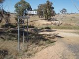
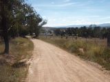
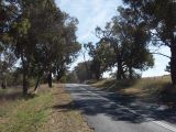
Downhill to the left, uphill to the right. Let's go left.
The correct path to take was right. Lots of people preparing for bonfires on the way.
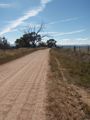
The road that lead me within 2km of the hash. It's a good thing I hadn't inflated my tires that morning, made it much easier to ride in this shit.
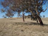
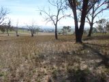
Just after jumping two fences, the fence that stopped me is behind the line of trees just short of the top of the hill.
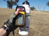
My gloves and I got within 1.5km of the hash, but not close enough.
The village of Lagoon on my walk back.
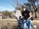
GoofyGrin(tm) coupled with a goofy pose. Do I get a ribbon for that?
More sand, more Lagoon. At least I was going downhill this time.
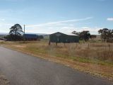
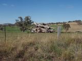
Lagoon Bushfire Brigade. The building to the left is a church of some sort, to the right there was a school (out of frame).
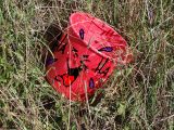
That bloody red bucket, it's a bad omen.
As soon as I pulled up for this photo Shufflemonster started playing "Still Alive". I suppose it was right, this is a nice ride.


