Difference between revisions of "2009-04-22 49 -122"
imported>Rhonda (→Gallery) |
imported>Rhonda (→Gallery) |
||
| Line 46: | Line 46: | ||
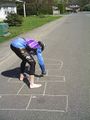
Image:2009-04-22_49_-122.robyn_hopscotch_throw.jpg|Robyn's throw | Image:2009-04-22_49_-122.robyn_hopscotch_throw.jpg|Robyn's throw | ||
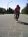
Image:2009-04-22_49_-122.robyn_hopscotch_1.jpg|Robyn's turn | Image:2009-04-22_49_-122.robyn_hopscotch_1.jpg|Robyn's turn | ||
| + | Image:2009-04-22_49_-122.robyn-hopscotch-landing.jpg|Precise landing as always! | ||
</gallery> | </gallery> | ||
Revision as of 03:39, 23 April 2009
| Wed 22 Apr 2009 in 49,-122: 49.1746352, -122.6529677 geohashing.info google osm bing/os kml crox |
Planning & Location
Vancouver's geohash was well out in the water today, possibly obtainable by taking two ferries and a kayak, but that's over five hours worth of ferries and waiting for ferries, plus two hours in a kayak, before even considering the time it would take to bike to and from the ferry, with a kayak on board, and the ferry tolls would total at least $40, probably fifty for all four trips.
One graticule over, the Surrey geohash is on a cul-de-sac in Maple Grove, which I believe is a district of Langley, not a town in itself. Robyn decided to bike the whole 45 km, while Rhonda was forced to take transit, her bicycle being in the shop for a tune up.
Expedition
Robyn
Rhonda
I had a pretty predictable transit expedition. The seabus, skytrain, and bus all left on schedule and connected nicely. Instead of taking the translink-recommended route of waiting 25 minutes for a community shuttle to get the last kilometer, I walked.

Two blocks from the turn I needed to take, something in the stand of trees at the side of the road caught my eye. I did a double-take and stared - something was waving an entire tree at me! I looked again, and saw nothing unusual, so I kept walking. As I got closer, I saw more tree-tops moving, and then finally saw what sort of machine was capable of picking up trees and waving them around. At the bottom of its grasping hand, there was a large, spinning, circular saw blade. I made a mental note not to cut through this particular empty lot at this time. The sign at the edge of the rapidly-diminishing forest said that there were going to be three lots developed there.
I continued around the corner, taking a second look at the tree-waving machine from the other side, then walked onward, watching my GPS arrow. When it pointed directly sideways, there was, conveniently enough, a street leading in that direction. So far, Google Maps and my GPS were agreeing.
I walked past a man doing some yard work in his front yard, and my GPS counted down below 10m... and then started counting back up again. Oh right, the arrow was pointing sideways again, to the side of the street that didn't have a sidewalk. I walked around a bit, trying to find what my GPS thought was the hash point, then took two photos of the GPS, neither of which are legible unless you know what it's supposed to say. The reflection of the camera in the GPS screen turned out fairly crisp however.
The man with the pruning shears and saw stood up and said, "Can I help you?"
"Um, I'm meeting a friend here, but I'm early."
He nodded and applied his cutting implements to the shrub and didn't chase me off.
I wandered around a bit, since I knew Robyn was going to show up probably in the next fifteen minutes or so. I tried to pat the kitty that was playing jungle in the shrubbery, but while it came up to sniff my hand thoroughly, it wouldn't let me touch.
Then I saw four bikes turn in at the end of the road; a group of three that meandered on and off the sidewalk, and a single racing style bicycle that headed directly down the street.
Both
Gallery

Kitty!
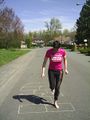
Game preparation
Robyn's throw
Robyn's turn
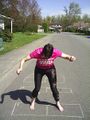
Precise landing as always!


