2009-05-03 48 -123
From Geohashing
Revision as of 04:32, 5 May 2009 by imported>Elbie (→Photos: second batch)
| Sun 3 May 2009 in 48,-123: 48.8703338, -123.5135538 geohashing.info google osm bing/os kml crox |
Location
On the side of a road on Salt Spring Island
Participants
Planning
Elbie:
- 9:00 - Bike to Airport Station
- 10:00 - Take the 620 to Tsawwassen
- 11:10 - Ferry departs from Tsawwassen to Salt Spring (Long Harbour) [1]
- 14:10 - arrive in Long Harbour; bike to hashpoint; take Long Harbour Road for 4.6km, then turn on Upper Ganges Road and follow it to the point (1.2km away) [2]
- around 15:00 - arrive at hashpoint. Take silly pictures of me in swashbuckling garb. Picnic?
- around 15:20 - start biking to Fulford Harbour. It's about 15km, should take me an hour, maybe two if I stop along the way. [3]
- 17:50 - ferry from Fulford Harbour departs to Swartz Bay [4]
- 18:30 - arrive in Swartz Bay
- 19:00 - ferry from Swartz Bay departs to Tsawwassen [5]
- arrive in Tsawwassen around 21:00, hopefully take the 620, bike home from Richmond
Expedition
It was a success! Writeup pending.
Photos
Pending.
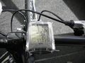
Elbie's odometer as she set off for the day.
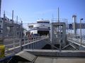
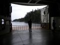
The ferry to Salt Spring, at Tsawwassen.

Elbie waiting to get on the ferry.
Elbie watched a lot of Battlestar Galactica on the ferry.

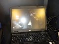
Elbie, camped out at one of the ferry's workstations, BSGing.
Eventually Elbie got some fresh air. After three episodes of BSG.
Arriving at Salt Spring Island.
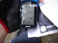
No GPS reception at the hashpoint.
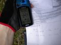
But GPS reception near the point, on both sides of the road.

Elbie triangulates the hashpoint from the places she can get reception at.
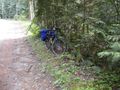
Elbie's bike, abandoned at the side of the road as she went to triangulate the coordinate.


