Difference between revisions of "2009-05-26 34 -84"
From Geohashing
(New page: {{meetup graticule | map=<map lat="34" lon="-84" date="2009-05-26" /> | lat=34 | lon=-84 | date=2009-05-26 | graticule_name=Talking Rock | graticule_link=Talking Rock, Georgia }} == Grati...) |
imported>NWoodruff m (→Gallery) |
||
| Line 24: | Line 24: | ||
== Gallery == | == Gallery == | ||
<gallery caption="Photo Gallery" widths="200px" heights="200px" perrow="3"> | <gallery caption="Photo Gallery" widths="200px" heights="200px" perrow="3"> | ||
| − | Image:20090526_34_-84NW01.JPG| | + | Image:20090526_34_-84NW01.JPG| From the road there was 159 feet to go. |
| + | Image:20090526_34_-84NW02.JPG| | ||
| + | Image:20090526_34_-84NW03.JPG| | ||
| + | Image:20090526_34_-84NW04.JPG| | ||
| + | Image:20090526_34_-84NW05.JPG| | ||
</gallery> | </gallery> | ||
Revision as of 00:02, 27 May 2009
| Tue 26 May 2009 in Talking Rock: 34.0329841, -84.5885297 geohashing.info google osm bing/os kml crox |
Contents
Graticule
About
People
Expeditions
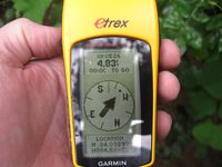
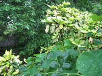
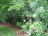
Gallery
- Photo Gallery
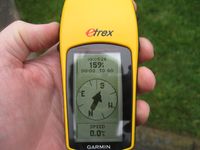
From the road there was 159 feet to go.
- 20090526 34 -84NW05.JPG


Nathan earned the Ambassador achievement
|
NWoodruff earned the Land geohash achievement
|