2009-05-30 49 10
| Sat 30 May 2009 in Bamberg: 49.7907899, 10.1342739 geohashing.info google osm bing/os kml crox |
Location
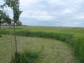
Today's location is in a barley field near Dettelbach-Biebergau.
Country: Germany; state: Bayern (Bavaria, EU:DE:BY); administrative region: Unterfranken; district: Kitzingen
Weather (16:00): clouded, windy, 21°C
Expedition
Danatar
I already knew the first 90% of the route to the hashpoint from various other expeditions, so there is nothing interesting to be told about. I arrived at the field at 15:55. I used tractor tire tracks to get into the field without trampling the plants and waited for 16:00 to take pictures.
On my way back I stopped at this graticule's virgin hashpoint to take some more pictures.
Total distance cycled: 16.8 km + 16.9 km = 33.7 km; 230 m uphill
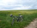
Almost there
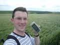
Coordinates reached at 4pm
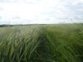
The hashpoint, as seen from a barley awn's height

The world, as seen from the hashpoint
Revisit of 2008-09-23


