Difference between revisions of "2009-06-01 33 -84"
imported>NWoodruff m (→Gallery) |
imported>FippeBot m (Location) |
||
| (2 intermediate revisions by one other user not shown) | |||
| Line 19: | Line 19: | ||
=== [[User:NWoodruff|NWoodruff]] === | === [[User:NWoodruff|NWoodruff]] === | ||
| + | Looking from the Google map, I originally though that this was a personal air field for someone that owned the property. It may have been looking at the map because there are straight paths cut in an "A" shape. When I got there it looked to be an abandoned work site. I noticed a sign that says that you could not enter for any illegal purpose. Geoshashing isn't illegal is it? The gate was wide open and there was a stop work notice posted on it. I assumed that with the gate wide open and sign stating no illegal entry that it was okay to go onto the property. | ||
| + | |||
| + | There were numerous dirt roads that were made. I navigated several to find the closest point to the Geohash point. After driving around for several minutes I finally found one with only 20 feet to go. I hopped out and found the hash point with 2 feet to go. | ||
| + | |||
| + | I took a few pictures and then drove home to Norcross. | ||
== Gallery == | == Gallery == | ||
| Line 28: | Line 33: | ||
Image:2009060133-84NW04.JPG| 2.49 feet to go. Close enough. | Image:2009060133-84NW04.JPG| 2.49 feet to go. Close enough. | ||
Image:2009060133-84NW05.JPG| Looking west from the Geohash point. | Image:2009060133-84NW05.JPG| Looking west from the Geohash point. | ||
| − | Image:2009060133-84NW06.JPG| | + | Image:2009060133-84NW06.JPG| Looking east from the geohash point. |
| − | Image:2009060133-84NW07.JPG| | + | Image:2009060133-84NW07.JPG| Looking North from the geohash point. |
</gallery> | </gallery> | ||
| Line 40: | Line 45: | ||
[[Category:Coordinates reached]] | [[Category:Coordinates reached]] | ||
[[Category:Expeditions with photos]] | [[Category:Expeditions with photos]] | ||
| + | {{location|US|GA|HY}} | ||
Latest revision as of 03:41, 8 August 2019
| Mon 1 Jun 2009 in Atlanta: 33.5503778, -84.1673527 geohashing.info google osm bing/os kml crox |
Graticule
About
Expedition
NWoodruff
Looking from the Google map, I originally though that this was a personal air field for someone that owned the property. It may have been looking at the map because there are straight paths cut in an "A" shape. When I got there it looked to be an abandoned work site. I noticed a sign that says that you could not enter for any illegal purpose. Geoshashing isn't illegal is it? The gate was wide open and there was a stop work notice posted on it. I assumed that with the gate wide open and sign stating no illegal entry that it was okay to go onto the property.
There were numerous dirt roads that were made. I navigated several to find the closest point to the Geohash point. After driving around for several minutes I finally found one with only 20 feet to go. I hopped out and found the hash point with 2 feet to go.
I took a few pictures and then drove home to Norcross.
Gallery
- Photo Gallery
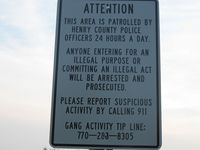
Geohashing isn't illegal is it?
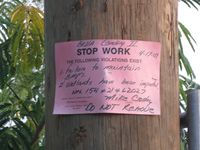
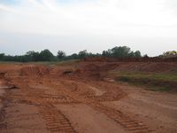
Nothing has been done here since April 17th.
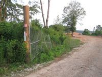
The gate is wide open.
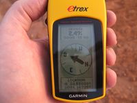
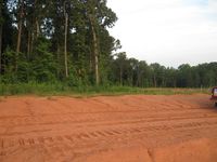
2.49 feet to go. Close enough.
Looking west from the Geohash point.
Looking east from the geohash point.
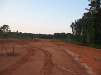
Looking North from the geohash point.


Achievements
NWoodruff earned the Land geohash achievement
|