2009-06-14 56 12
From Geohashing
Revision as of 18:53, 14 June 2009 by imported>Anders (→Achievements)

| Sun 14 Jun 2009 in 56,12: 56.0595272, 12.7652863 geohashing.info google osm bing/os kml crox |
Participants
Expedition
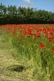
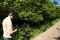
We took of from Ängelholm on a sunny morning and fought the wind by bike towards Helsingborg. When we arrived close to the spot we realized that the hash was located in a small forest with tiny trees and a lot of half meter nettles on the ground. Dressed in just shorts and sandals we entered the nettle forest. After a lot of circulation and "leg-scratching" we finally found what we were looking for. On our way back we took a well deserved ice cream stop in Strövelstorp. That is the spot were the gps lost connection, and the track therefore ended.
Tracklog
Achievements
Anders and Gabriel earned the Land geohash achievement
|
Anders and Gabriel earned the Bicycle geohash achievement
|
Gabriel achieved level 2 of the Minesweeper Geohash achievement
|
Gabriel earned the Drag-along achievement
|
Photos
Anders
Gabriel

