Difference between revisions of "2009-06-17 56 13"
imported>Anders (→Expedition) |
imported>FippeBot m (Location) |
||
| (5 intermediate revisions by one other user not shown) | |||
| Line 14: | Line 14: | ||
== Expedition == | == Expedition == | ||
| − | The spot today was situated in very beatiful area north of Rössjön and not so far away. | + | The spot today was situated in very beatiful area north of Rössjön and not so far away from home. Without much hesitation we decided to head for the point. The weather was rather good with almost no wind. Our bike tour went through nice forests and lakes of Skåne so we enjoyed the trip very much. Almost on target we had to answer some computer support on the phone. The target area was significantly easier to walk in than the nettles we walked through on our last expedition and we found the target the most accurate we could with our gps-phones. |
| − | Our | ||
| − | significantly easier to walk in than the nettles we walked through last expedition | ||
== Tracklog == | == Tracklog == | ||
| Line 30: | Line 28: | ||
<gallery perrow="5"> | <gallery perrow="5"> | ||
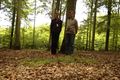
Image:2009-06-17-3.jpg | Us at the hash | Image:2009-06-17-3.jpg | Us at the hash | ||
| − | Image:2009-06-17-4.jpg | | + | Image:2009-06-17-4.jpg | Rössjön |
| − | Image:2009-06-17-5.jpg | | + | Image:2009-06-17-5.jpg | The road close to the lake |
| − | Image:2009-06-17-6.jpg | | + | Image:2009-06-17-6.jpg | Difficult road to enter with citybikes |
| − | Image:2009-06-17-7.jpg | | + | Image:2009-06-17-7.jpg | Almost on the spot we had to walk the last part |
| − | Image:2009-06-17-8.jpg | | + | Image:2009-06-17-8.jpg | Elk hunting tower near the hash |
| − | Image:2009-06-17-9.jpg | | + | Image:2009-06-17-9.jpg | Computer support seems to be a common part of our geohashing |
| − | Image:2009-06-17-10.jpg | | + | Image:2009-06-17-10.jpg | Precision positioning |
| − | Image:2009-06-17-11.jpg | | + | Image:2009-06-17-11.jpg | Self timer is often useful |
</gallery> | </gallery> | ||
| Line 43: | Line 41: | ||
[[Category:Coordinates reached]] | [[Category:Coordinates reached]] | ||
[[Category:Expeditions with photos]] | [[Category:Expeditions with photos]] | ||
| + | {{location|SE|M}} | ||
Latest revision as of 03:59, 8 August 2019

| Wed 17 Jun 2009 in 56,13: 56.3287508, 13.1075645 geohashing.info google osm bing/os kml crox |
Participants
Expedition
The spot today was situated in very beatiful area north of Rössjön and not so far away from home. Without much hesitation we decided to head for the point. The weather was rather good with almost no wind. Our bike tour went through nice forests and lakes of Skåne so we enjoyed the trip very much. Almost on target we had to answer some computer support on the phone. The target area was significantly easier to walk in than the nettles we walked through on our last expedition and we found the target the most accurate we could with our gps-phones.
Tracklog
Achievements
Anders and Gabriel earned the Land geohash achievement
|
Anders and Gabriel earned the Bicycle geohash achievement
|
Gabriel achieved level 3 of the Minesweeper Geohash achievement
|
Anders achieved level 1 of the Minesweeper Geohash achievement
|
Photos
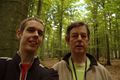
Us at the hash
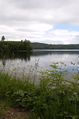
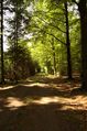
Rössjön
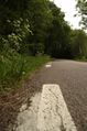
The road close to the lake
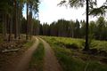
Difficult road to enter with citybikes
Almost on the spot we had to walk the last part
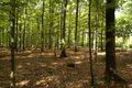
Elk hunting tower near the hash
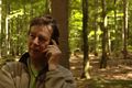
Computer support seems to be a common part of our geohashing
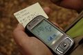
Precision positioning
Self timer is often useful


