Difference between revisions of "2009-06-24 33 -84"
imported>NWoodruff m (→Gallery) |
imported>FippeBot m (Location) |
||
| (7 intermediate revisions by 2 users not shown) | |||
| Line 19: | Line 19: | ||
=== [[User:NWoodruff|NWoodruff]] === | === [[User:NWoodruff|NWoodruff]] === | ||
| − | Google maps sent me down a street that was no longer a street. I had to find my own way to the hash point. | + | Google maps sent me down a street that was no longer a street. I had to find my own way to the hash point. I do have the track log if any one is interested in my path that I had to take to find the hash point. Byron road here [http://maps.google.com/maps?f=d&source=s_d&saddr=2593+kennesaw+due+west+30144&daddr=%2B33%C2%B0+19%27+43.10%22,+-84%C2%B0+33%27+54.52%22+(33.328640,+-84.565145)&hl=en&geocode=%3BFf-N_AEdaKP1-g&mra=ls&sll=33.329632,-84.564686&sspn=0.018287,0.031242&ie=UTF8&ll=33.345197,-84.563447&spn=0.002285,0.003905&t=h&z=18] is now blocked from public access. |
| + | I drove around for quite some time. I almost gave up. But when I got within 1 mile of the hash point. I almost decided to walk from that point. I'm glad that I decided to drive around some more. I eventually found the south end of the road that Byron road was supposed to turn on from the North end. | ||
| + | |||
| + | I walked to the house and knocked on the door. Denise answered the door. I explained myself and geohashing. I told her that I wanted to access a GPS coordinate about 100 feet into her woods. She told me that it would be Okay. Permission Granted. | ||
| + | |||
| + | I found the Geohash point with little problem. I took a few pictures and then headed back for Norcross. | ||
== Gallery == | == Gallery == | ||
| Line 26: | Line 31: | ||
<gallery caption="Photo Gallery" widths="200px" heights="200px" perrow="3"> | <gallery caption="Photo Gallery" widths="200px" heights="200px" perrow="3"> | ||
Image:2009062433-84NW01.JPG| Google maps sent me down a road that is now blocked from public access. I was now on my own to find the hash location with out any map. | Image:2009062433-84NW01.JPG| Google maps sent me down a road that is now blocked from public access. I was now on my own to find the hash location with out any map. | ||
| − | Image:2009062433-84NW02.JPG| | + | Image:2009062433-84NW02.JPG| From where I parked, there was 156 feet to go into the woods. |
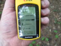
| − | Image:2009062433-84NW03.JPG| | + | Image:2009062433-84NW03.JPG| 1.25 feet to go. Close enough. |
| − | Image:2009062433-84NW04.JPG| | + | Image:2009062433-84NW04.JPG| Stupid grin™ |
| − | Image:2009062433-84NW05.JPG| | + | Image:2009062433-84NW05.JPG| Time of day. |
| − | |||
</gallery> | </gallery> | ||
| Line 36: | Line 40: | ||
{{land geohash | latitude = 33 | longitude = -84| date = 2009-06-24| name = NWoodruff}} | {{land geohash | latitude = 33 | longitude = -84| date = 2009-06-24| name = NWoodruff}} | ||
| + | {{consecutive geohash | count = 3 | latitude = 33 | longitude = -84 | date = 2009-06-22 | name = NWoodruff }} | ||
| + | |||
| + | |||
| Line 41: | Line 48: | ||
[[Category:Coordinates reached]] | [[Category:Coordinates reached]] | ||
[[Category:Expeditions with photos]] | [[Category:Expeditions with photos]] | ||
| + | {{location|US|GA|CA}} | ||
Latest revision as of 04:08, 8 August 2019
| Wed 24 Jun 2009 in Atlanta: 33.3286410, -84.5651450 geohashing.info google osm bing/os kml crox |
Graticule
About
Expedition
NWoodruff
Google maps sent me down a street that was no longer a street. I had to find my own way to the hash point. I do have the track log if any one is interested in my path that I had to take to find the hash point. Byron road here [1] is now blocked from public access.
I drove around for quite some time. I almost gave up. But when I got within 1 mile of the hash point. I almost decided to walk from that point. I'm glad that I decided to drive around some more. I eventually found the south end of the road that Byron road was supposed to turn on from the North end.
I walked to the house and knocked on the door. Denise answered the door. I explained myself and geohashing. I told her that I wanted to access a GPS coordinate about 100 feet into her woods. She told me that it would be Okay. Permission Granted.
I found the Geohash point with little problem. I took a few pictures and then headed back for Norcross.
Gallery
- Photo Gallery
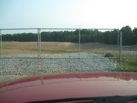
Google maps sent me down a road that is now blocked from public access. I was now on my own to find the hash location with out any map.
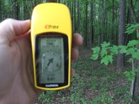
From where I parked, there was 156 feet to go into the woods.
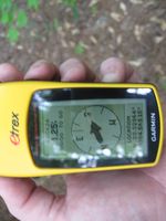
1.25 feet to go. Close enough.
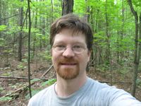
Stupid grin™
Time of day.


Achievements
NWoodruff earned the Land geohash achievement
|
NWoodruff earned the Consecutive geohash achievement
|