Difference between revisions of "2009-07-01 48 11"
imported>FippeBot m (Location) |
|||
| Line 37: | Line 37: | ||
}} | }} | ||
| + | [[Category:Expeditions]] | ||
[[Category:Expeditions with photos]] | [[Category:Expeditions with photos]] | ||
[[Category:Coordinates reached]] | [[Category:Coordinates reached]] | ||
{{location|DE|BY|M}} | {{location|DE|BY|M}} | ||
Latest revision as of 17:49, 19 April 2021
| Wed 1 Jul 2009 in München, Germany: 48.0283638, 11.4602629 geohashing.info google osm bing/os kml crox |
Location
The edge of the Forstenrieder Park (wildlife park) southwest of Munich. Public transportation in the nearby villages of Buchenhain and Baierbrunn.
Expedition
I live in the southwest part of Munich and already did some excursions to the Park, so i decided to walk. I started at about 1.30 pm from home and crossed the outskirts of Munich for about 5.3 kilometers and the Park for about 6.1 kilometers (according to Google Maps). Since i have no GPS device, i don't know if i picked the exact spot, but following the road pattern i was at least passing by.

After that i planned on walking back home to achieve the longest distance walked, but it started raining. So i took the train back home. Total distance therefore: 11.4 km
Photos
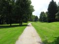
Outskirts of Munich (km 4)
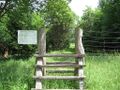
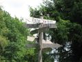
Park Entrance (km 6)
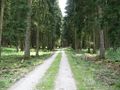
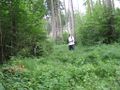
Forest road (km 7)
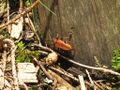
Hashinsect! (km 7)
Yeah... whatever (km 8)
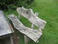
Thats a nice bench (km 8)
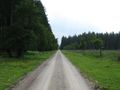
Long road is long (km 10)
Hashpoint (approximately) (km 11.4)


Nusa earned the Walk geohash Achievement
|