Difference between revisions of "2009-07-06 42 -72"
imported>Sara (Creating Page) |
imported>FippeBot m (Location) |
||
| (3 intermediate revisions by one other user not shown) | |||
| Line 1: | Line 1: | ||
| − | |||
<!-- If you did not specify these parameters in the template, please substitute appropriate things for IMAGE, LAT, LON, and DATE (YYYY-MM-DD format) --> | <!-- If you did not specify these parameters in the template, please substitute appropriate things for IMAGE, LAT, LON, and DATE (YYYY-MM-DD format) --> | ||
| − | + | [[Image:{{{image|2009_07_06_42_-72_digger.JPG}}}|thumb|left]] | |
| − | [[Image:{{{image| | ||
| − | |||
{{meetup graticule | {{meetup graticule | ||
| lat=42 | | lat=42 | ||
| Line 14: | Line 11: | ||
== Location == | == Location == | ||
| + | On the shoulder of Route 20 in Wilbraham, Massachusetts, at the Wilbraham Department of Public Works building. | ||
== Participants == | == Participants == | ||
| + | [[User:Sara|Sara]] and her son, who just turned four. | ||
== Plans == | == Plans == | ||
| + | This looked like a geohash that would be possible to get to without a GPS, because it's in front of the third tree shown on Google satellite view, and the point is not very far from my kids' school where I had to pick up my son today anyway. On the other hand, the site didn't look very interesting to me, and I had driven by there before, so I almost decided not to go. | ||
| + | |||
| + | The only reason it looked uninteresting was I was failing to take into account my son's great interest in vehicles. | ||
== Expedition == | == Expedition == | ||
| + | My son and I drove over there after I picked him up from nursery school. In the car on the way over, he said that if I was going to take pictures of him, he also wanted to take pictures of me. | ||
| − | + | After some whining about how long the drive was taking, we arrived at the Wilbraham Dept. of Public Works. I took a picture of my son in front of a digger, and then we went over to the row of trees next to the road and together we counted off three trees. There was no asphalt to mark with chalk, so I made an X with sticks. | |
| + | By this time, my son had gotten control of the camera and had figured out that the wrist strap doesn't go over one's head, and he was having a great time trying to photograph the many cars and trucks driving by on Route 20. I managed to get the camera away from him for a moment to take a couple pictures. He would have wanted to stay there all day photographing vehicles, but the camera's batteries were running out. | ||
== Photos == | == Photos == | ||
<gallery perrow="3"> | <gallery perrow="3"> | ||
| − | Image: | + | Image:2009_07_06_42_-72_digger.JPG | This isn't the hashpoint, but my son said if I was going to take his picture, I had to take one here. |
| − | Image:2009- | + | Image:2009_07_06_42_-72_sign.JPG | Proof of location, and garbage truck. |
| + | Image:2009_07_06_42_-72_grin.JPG | Son at the hashpoint. I have no idea why he wanted the chalk to be in the picture. | ||
| + | Image:2009 06 07 42 -72 s westward.JPG | By popular demand, here's one of the pictures my son took. | ||
| + | Image:2009_07_06_42_-72_s_point.JPG | And another one. | ||
</gallery> | </gallery> | ||
| − | |||
| − | |||
| − | |||
| − | |||
| − | |||
| − | |||
| − | |||
| − | |||
[[Category:Expeditions]] | [[Category:Expeditions]] | ||
[[Category:Expeditions with photos]] | [[Category:Expeditions with photos]] | ||
| − | |||
[[Category:Expedition without GPS]] | [[Category:Expedition without GPS]] | ||
| − | |||
| − | |||
| − | |||
[[Category:Coordinates reached]] | [[Category:Coordinates reached]] | ||
| − | + | {{location|US|MA|HD}} | |
| − | |||
| − | |||
| − | |||
| − | |||
| − | |||
| − | |||
| − | |||
| − | |||
| − | |||
Latest revision as of 04:22, 8 August 2019

| Mon 6 Jul 2009 in 42,-72: 42.1514259, -72.4273747 geohashing.info google osm bing/os kml crox |
Location
On the shoulder of Route 20 in Wilbraham, Massachusetts, at the Wilbraham Department of Public Works building.
Participants
Sara and her son, who just turned four.
Plans
This looked like a geohash that would be possible to get to without a GPS, because it's in front of the third tree shown on Google satellite view, and the point is not very far from my kids' school where I had to pick up my son today anyway. On the other hand, the site didn't look very interesting to me, and I had driven by there before, so I almost decided not to go.
The only reason it looked uninteresting was I was failing to take into account my son's great interest in vehicles.
Expedition
My son and I drove over there after I picked him up from nursery school. In the car on the way over, he said that if I was going to take pictures of him, he also wanted to take pictures of me.
After some whining about how long the drive was taking, we arrived at the Wilbraham Dept. of Public Works. I took a picture of my son in front of a digger, and then we went over to the row of trees next to the road and together we counted off three trees. There was no asphalt to mark with chalk, so I made an X with sticks.
By this time, my son had gotten control of the camera and had figured out that the wrist strap doesn't go over one's head, and he was having a great time trying to photograph the many cars and trucks driving by on Route 20. I managed to get the camera away from him for a moment to take a couple pictures. He would have wanted to stay there all day photographing vehicles, but the camera's batteries were running out.
Photos

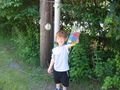
This isn't the hashpoint, but my son said if I was going to take his picture, I had to take one here.
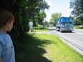
Proof of location, and garbage truck.
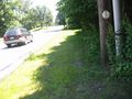
Son at the hashpoint. I have no idea why he wanted the chalk to be in the picture.
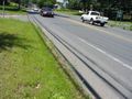
By popular demand, here's one of the pictures my son took.
And another one.


