Difference between revisions of "2009-07-16 57 16"
imported>Gabriel (→Photos) |
(→Photos) |
||
| Line 44: | Line 44: | ||
Image: 2009-07-16-57-16-6.jpg | Stone board for driving practice | Image: 2009-07-16-57-16-6.jpg | Stone board for driving practice | ||
Image: 2009-07-16-57-16-8.jpg | Picnic by the sea | Image: 2009-07-16-57-16-8.jpg | Picnic by the sea | ||
| − | Image: 2009-07-16-57-16-9.jpg | Ulf qualifying for both geoflashing and the | + | Image: 2009-07-16-57-16-9.jpg | Ulf qualifying for both geoflashing and the calendar girl achievement |
</gallery> | </gallery> | ||
Revision as of 08:45, 17 July 2009

| Thu 16 Jul 2009 in 57,16: 57.0361713, 16.8285036 geohashing.info google osm bing/os kml crox |
Participants
Expedition
When staying at my (Jonatan's) parents' summer place, we're really happy for every day we get any opportunity to hash. A great deal of the graticule areas close to us are unsuitable for geohashing. Either because it's open sea or you have to exit the graticule in order to pass a bridge ~80 km south of the house and then go the same distance back again in order to reenter it. Today we were even more lucky than usual. The hash point was situated in an old quarry only a few (two or three, I think) kilometres from the house! If that weren't enough we had been in that quarry at the exact hash point only a few days ago. Strange but nice coinsidence. :-)
Because of the extraordinary easy point today, we decided to walk and also wanted to make it somewhat more entertaining by trying to go for the tron achievement. In order to increase our chances of success, we hired two scouts (ehrm, my parents - Ulf and Britt-Inger). As a matter of fact, they turned out to prove very useful. Ulf was a very eager scout and always darted forward trying to fulfill that the tron route mustn't be crossed. Britt-Inger did her job by ponting out the silliness of geohashing, and how dumb it is to let fate decide where you go.
The journey to the hash point was actually slightly difficult. Ulf had an old map of the area, showing us a small path, right where we wanted to cross some terrain. The path was probably very suitable for our purpose for about 20 years ago. Now it was hard to find, mostly grown over and filled with obstacles (shut closed gates, buckthorn...) on it's way.
After slightly more than an hour we got out of the forest - bitten by insects, stung by buckthorn and, in the case of Britt-Inger, hit bloody because of an appointment with an evil sprig, which clearly aimed for (and also hit) her left eye. Even though we were a slightly tarnished group, now emerging from the the woods, we still celebrated that we made it through without spoiling the tron track so far!
Quarter of an hour later, we stood at the hash point in the quarry and looked at the traces we had left a few days ago when we last visited the place. After taking some photos of important things (mostly stones) we headed for the nearby water, and had a nice picnic there.
The return journey was very easy, because we were now able to use the ordinary stone road (instead of some improvised non-path) and returned safely at home after approx. 20 minutes.
Comments regarding the tron achievement and tracklog
If you look at the tracklog, you'll see that it actually crosses itself once. This was, however, not the case in the reality but was caused because by the gps flipping out and adding one point, which we did not pass, to the tracklog. This is also the explanation to the tracklog showing ~17 km/h as our max speed during the expedition, despite walking. There is, in fact, no reason we should continue to walk in a straight line for 15 meters after reaching the hash, despite walking through one body of shallow and very disgusting water only to reach nothing and then turn back and walk almost exactly the same way back to the point again only to turn in the right direction and continue walking that way... :-)
Achievements
Jonatan and Gabriel earned the Land geohash achievement
|
Jonatan and Gabriel earned the Walk geohash Achievement
|
Jonatan and Gabriel earned the Tron achievement
|
Jonatan and Gabriel earned the Drag-along achievement
|
Jonatan and Gabriel earned the Consecutive geohash achievement
|
Jonatan and Gabriel earned the Déjà Vu Geohash Achievement
|
Jonatan and Gabriel earned the Picnic achievement
|
Photos
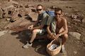
Jonatan and Ulf at the hash

Gabriel at the hash

Marking

Proof of deja vu ribbon
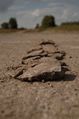
Stone board for driving practice

Picnic by the sea

Ulf qualifying for both geoflashing and the calendar girl achievement


