Difference between revisions of "2009-07-29 45 -123"
imported>Jiml (Start page) |
imported>FippeBot m (Location) |
||
| (7 intermediate revisions by one other user not shown) | |||
| Line 1: | Line 1: | ||
| − | |||
| − | |||
| − | |||
| − | |||
| − | |||
{{meetup graticule | {{meetup graticule | ||
| lat=45 | | lat=45 | ||
| Line 10: | Line 5: | ||
}} | }} | ||
| − | |||
| − | |||
== Location == | == Location == | ||
| − | + | South of Banks, Oregon, on the edge of a newly harvested grain field. | |
== Participants == | == Participants == | ||
| + | *[[User:Jiml|Jim]] | ||
== Plans == | == Plans == | ||
| + | |||
| + | Plans?? Hah! It's 103 degrees out and I have errands to do. I went by on my way home. I programmed the GPS with the coordinates, and took a GoogleMaps printout, not that I initially followed it. | ||
== Expedition == | == Expedition == | ||
| + | After completing my errands preparing for our trip East, I drove out to Banks to try to find the | ||
| + | hashpoint. | ||
| + | In the process of getting to the point, I went around a triangle intersection in the road, with a | ||
| + | lot of brush in the middle of the triangle. As I went around it, the GPS pointed into the middle of | ||
| + | it. Clearly I had crossed the stupidity distance, as I was strongly tempted to get out of | ||
| + | the car and plunge directly into the middle of it. | ||
| − | + | However, sanity prevailed and I realized that the hashpoint was actually on the other side of the road, | |
| + | just as I suspected from Google Maps. So, I walked around the triangle and crossed the road. | ||
| + | I found myself confronting a hedge, probably full of raptors. However, the stupidity distance | ||
| + | had been crossed, so I plunged in (slowly) and managed to evade any bites as I made it to the other | ||
| + | side of the brush. There I found the hashpoint on the edge of the field. | ||
| + | I took a picture and headed home. | ||
| + | |||
| + | == Achievements == | ||
| + | {{land geohash | latitude = 45 | longitude = -123 | date = 2009-07-29 | name = [[User:Jiml|Jim]] }} | ||
== Photos == | == Photos == | ||
<gallery perrow="3"> | <gallery perrow="3"> | ||
| − | Image:2009- | + | Image:2009-07-29 45 -123-NearbyField.jpg|Nearby field showing the area |
| − | Image:2009- | + | Image:2009-07-29 45 -123-StupidityTriangle.jpg|The triangle that I was nearly stupid in |
| + | Image:2009-07-29_45_-123-hedge.jpg|Picture of the raptor-laden hedge | ||
| + | Image:2009-07-29_45_-123-GPS.jpg|GPS makes it to the hashpoint | ||
| + | Image:2009-07-29_45_-123-TowardsHashpoint.jpg|Picture back towards the hashpoint | ||
</gallery> | </gallery> | ||
| − | |||
| − | |||
| − | |||
| − | |||
| − | |||
| − | |||
| − | |||
| − | |||
[[Category:Expeditions]] | [[Category:Expeditions]] | ||
[[Category:Expeditions with photos]] | [[Category:Expeditions with photos]] | ||
| − | |||
| − | |||
| − | |||
| − | |||
| − | |||
[[Category:Coordinates reached]] | [[Category:Coordinates reached]] | ||
| − | + | {{location|US|OR|WI}} | |
| − | |||
| − | |||
| − | |||
| − | |||
| − | |||
| − | |||
| − | |||
| − | |||
| − | |||
Latest revision as of 04:50, 8 August 2019
| Wed 29 Jul 2009 in 45,-123: 45.5804344, -123.1123241 geohashing.info google osm bing/os kml crox |
Location
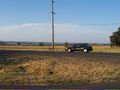
South of Banks, Oregon, on the edge of a newly harvested grain field.
Participants
Plans
Plans?? Hah! It's 103 degrees out and I have errands to do. I went by on my way home. I programmed the GPS with the coordinates, and took a GoogleMaps printout, not that I initially followed it.
Expedition
After completing my errands preparing for our trip East, I drove out to Banks to try to find the hashpoint.
In the process of getting to the point, I went around a triangle intersection in the road, with a lot of brush in the middle of the triangle. As I went around it, the GPS pointed into the middle of it. Clearly I had crossed the stupidity distance, as I was strongly tempted to get out of the car and plunge directly into the middle of it.
However, sanity prevailed and I realized that the hashpoint was actually on the other side of the road, just as I suspected from Google Maps. So, I walked around the triangle and crossed the road.
I found myself confronting a hedge, probably full of raptors. However, the stupidity distance had been crossed, so I plunged in (slowly) and managed to evade any bites as I made it to the other side of the brush. There I found the hashpoint on the edge of the field. I took a picture and headed home.
Achievements
Jim earned the Land geohash achievement
|
Photos
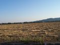
Nearby field showing the area
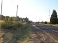
The triangle that I was nearly stupid in
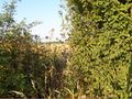
Picture of the raptor-laden hedge
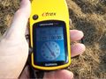
GPS makes it to the hashpoint
Picture back towards the hashpoint


