Difference between revisions of "2009-08-02 52 -1"
From Geohashing
imported>FippeBot m (Location) |
|||
| (One intermediate revision by one other user not shown) | |||
| Line 23: | Line 23: | ||
<gallery perrow="3"> | <gallery perrow="3"> | ||
| − | Image:2009-08-02_52_-1_Point. | + | Image:2009-08-02_52_-1_Point.JPG | The hashpoint |
| − | Image:2009-08-02_52_-1_GPS. | + | Image:2009-08-02_52_-1_GPS.JPG | Me with GPS. Odd expression due to trying to hold GPS and take photo with a camera that's battery compartment falls apart. |
</gallery> | </gallery> | ||
| Line 30: | Line 30: | ||
[[Category:Expeditions with photos]] | [[Category:Expeditions with photos]] | ||
[[Category:Coordinates reached]] | [[Category:Coordinates reached]] | ||
| + | {{location|GB|ENG|LEC}} | ||
Latest revision as of 04:58, 8 August 2019
| Sun 2 Aug 2009 in 52,-1: 52.5333294, -1.1774206 geohashing.info google osm bing/os kml crox |
Location
In a field just off the M1, accessible by footpath from Willoughby Waterleys.
Participants
Expedition
I travelled by car to Willoughby, and then walked out on the footpath around 15:40. The target was in a grass field with a couple of horses, so I wandered down the field to the exact hashpoint, or as close as my GPS would detect, anyway. It seems to be very reluctant to change the displayed coordinates if you only move a meter or two, even if the HDoP is less than a meter. I got the photo to the nearest arc-second, anyway.
Photos
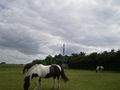
The hashpoint

Me with GPS. Odd expression due to trying to hold GPS and take photo with a camera that's battery compartment falls apart.

