2009-08-11 51 8
| Tue 11 Aug 2009 in 51,8: 51.8933175, 8.4837397 geohashing.info google osm bing/os kml crox |
Location
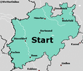
In the middle of a field north of north-west of Verl and east of Sürenheide.
Participants
Expedition
I'm planning on cycling up the L756 first till I arrive in Hövelhof. There I switch onto the L757 all the way to Verl. Switching again onto the L787 this time and cycling the Bükersweg to a little patch of trees (doesn't really look like a forest to me, way too small). From there on it's time to walk straight south through the trees and onto a field to reach the hashpoint.
Home I'll most likely use the same way, thus cycling a bit over 50km this time.
Ah how typical, just as I had everything packed and went out of the house it started raining heavily. A look at a weather page online showed that even more rain is on the way. Abandoned my plan and decided to try my luck another day.
Photos
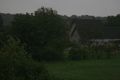
Mother Nature is a cruel mistress!
The outlook doesn't make it any better...

