Difference between revisions of "2009-08-16 50 11"
imported>Reinhard m (+h) |
imported>FippeBot m (Location) |
||
| (One intermediate revision by one other user not shown) | |||
| Line 5: | Line 5: | ||
| date=2009-08-16 | | date=2009-08-16 | ||
}} | }} | ||
| + | == Participants == | ||
| + | * [[User:Reinhard|Reinhard]] | ||
| + | == Expedition == | ||
[[User:Reinhard|Reinhard]] came back late from Fürth, where he spent the weekend, but couldn't miss the Sunday geohash, which was again close to the Hermsdorfer Kreuz (A4/A9). This time, Reinhard had already left the motorway at the usual exit Bad Klosterlausnitz and only had to drive a detour of 3 km to get to the closest place to park the car for a quick night geohash. It was really dark and the hash was in a forest, so Reinhard took his bright bike headlight with him. With the help of his topographic electronic map he quickly found the probably-very-nice-at-daylight forest path and went about 350 m until he had to leave it to the left for about 50 m to find the hashpoint. There it was, in the dark forest, quite easy to reach. | [[User:Reinhard|Reinhard]] came back late from Fürth, where he spent the weekend, but couldn't miss the Sunday geohash, which was again close to the Hermsdorfer Kreuz (A4/A9). This time, Reinhard had already left the motorway at the usual exit Bad Klosterlausnitz and only had to drive a detour of 3 km to get to the closest place to park the car for a quick night geohash. It was really dark and the hash was in a forest, so Reinhard took his bright bike headlight with him. With the help of his topographic electronic map he quickly found the probably-very-nice-at-daylight forest path and went about 350 m until he had to leave it to the left for about 50 m to find the hashpoint. There it was, in the dark forest, quite easy to reach. | ||
| Line 19: | Line 22: | ||
[[Category:Expeditions with photos]] | [[Category:Expeditions with photos]] | ||
[[Category:Coordinates reached]] | [[Category:Coordinates reached]] | ||
| + | {{location|DE|TH|SHK}} | ||
Latest revision as of 05:13, 8 August 2019
| Sun 16 Aug 2009 in 50,11: 50.8929070, 11.8161114 geohashing.info google osm bing/os kml crox |
Participants
Expedition
Reinhard came back late from Fürth, where he spent the weekend, but couldn't miss the Sunday geohash, which was again close to the Hermsdorfer Kreuz (A4/A9). This time, Reinhard had already left the motorway at the usual exit Bad Klosterlausnitz and only had to drive a detour of 3 km to get to the closest place to park the car for a quick night geohash. It was really dark and the hash was in a forest, so Reinhard took his bright bike headlight with him. With the help of his topographic electronic map he quickly found the probably-very-nice-at-daylight forest path and went about 350 m until he had to leave it to the left for about 50 m to find the hashpoint. There it was, in the dark forest, quite easy to reach.
- Photo Gallery
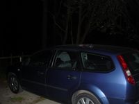
Car parked somewhere in the dark near Schleifreisen.
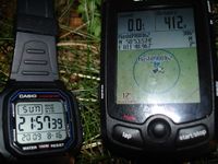
Proof of coordinates and date.
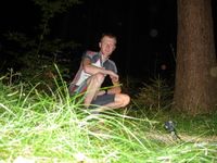
Reinhard at the hashpoint, still in the bike clothes he wore at the bike trip near Fürth.


