Difference between revisions of "2009-08-21 54 12"
imported>Jiml m (Give it a template) |
imported>Jiml (Add template to make APBot happy) |
||
| Line 1: | Line 1: | ||
| − | |||
| − | |||
| − | |||
| − | |||
| − | |||
| − | |||
{{meetup graticule | {{meetup graticule | ||
| lat=54 | | lat=54 | ||
| Line 11: | Line 5: | ||
}} | }} | ||
| − | + | ||
| − | |||
== Location == | == Location == | ||
| + | It's near the village of Pölchow, | ||
== Participants == | == Participants == | ||
| − | + | * [[user:Trurl]] | |
== Plans == | == Plans == | ||
| + | I didn't put up the meeting page beforehand, because I did grasp that principle only afterwards. | ||
== Expedition == | == Expedition == | ||
| − | |||
| − | |||
| − | |||
| − | |||
| − | |||
| − | |||
| − | |||
| − | |||
| − | |||
| − | |||
| − | |||
| − | |||
| − | |||
| − | |||
| − | |||
| − | |||
| − | |||
| − | |||
| − | |||
| − | |||
| − | |||
| − | |||
| − | |||
| − | |||
| − | |||
| − | |||
| − | |||
| − | |||
| − | |||
| − | |||
| − | |||
| − | |||
| − | |||
| − | |||
| − | |||
| − | |||
| − | |||
| − | |||
| − | |||
| − | |||
| − | |||
| − | |||
| − | |||
| − | |||
| Line 78: | Line 29: | ||
Not much else to tell about that spot. It's near the village of Pölchow, and the immediate surroundings are pretty rural, but an Autobahn is only ~ 100 m away. | Not much else to tell about that spot. It's near the village of Pölchow, and the immediate surroundings are pretty rural, but an Autobahn is only ~ 100 m away. | ||
| + | == Photos == | ||
<gallery> | <gallery> | ||
Image:2009-08-21 54 12 the spot.JPG|The hash | Image:2009-08-21 54 12 the spot.JPG|The hash | ||
Revision as of 00:32, 22 August 2009
| Fri 21 Aug 2009 in 54,12: 54.0181646, 12.0780598 geohashing.info google osm bing/os kml crox |
Contents
Location
It's near the village of Pölchow,
Participants
Plans
I didn't put up the meeting page beforehand, because I did grasp that principle only afterwards.
Expedition
I visited the 2009-08-21 geohash in the Rostock, Germany graticule (that also encompasses parts of Denmark and a lot of Baltic Sea).
It seems to have been the first documented hash in that graticule. Also, it was my first hash.
I didn't put up the meeting page beforehand, because I did grasp that principle only afterwards. So, I met nobody, but a snail, and a single car passing by on the small country road.
Not much else to tell about that spot. It's near the village of Pölchow, and the immediate surroundings are pretty rural, but an Autobahn is only ~ 100 m away.
Photos
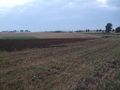
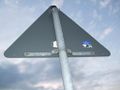
The hash
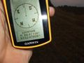
... on GPS
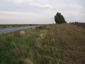
East view
West view
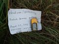
Left a marker a few meters from the hash
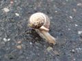
Hashsnail


