Difference between revisions of "2009-08-22 50 11"
imported>Reinhard (gallery) |
imported>FippeBot m (Location) |
||
| (2 intermediate revisions by one other user not shown) | |||
| Line 5: | Line 5: | ||
| date=2009-08-22 | | date=2009-08-22 | ||
}} | }} | ||
| + | == Participants == | ||
| + | * [[user:Manu|Manu]] | ||
| + | * [[user:Reinhard|Reinhard]] | ||
| + | == Expedition == | ||
[[user:Manu|Manu]] and [[User:Reinhard|Reinhard]] spent the weekend in the Thuringian forest and thought about what to do on that Saturday. There hasn't been any close hashpoint, but the 50-11-hashpoint looked reachable and was in a nice area in the Frankenwald, so they decided to drive most of the way (to Pressig) with the bikes in the car and then cycle the rest to the hashpoint, which was about 10 km from Pressig near Wickendorf on a meadow. That's what they did (mostly cycling uphill from Pressig) and after the successful and unspectacular geohash they continued their ride always going up or down back to Pressig - in the end it was a bike trip of 47.4 km with 867 m total ascent and a bit more of driving ... | [[user:Manu|Manu]] and [[User:Reinhard|Reinhard]] spent the weekend in the Thuringian forest and thought about what to do on that Saturday. There hasn't been any close hashpoint, but the 50-11-hashpoint looked reachable and was in a nice area in the Frankenwald, so they decided to drive most of the way (to Pressig) with the bikes in the car and then cycle the rest to the hashpoint, which was about 10 km from Pressig near Wickendorf on a meadow. That's what they did (mostly cycling uphill from Pressig) and after the successful and unspectacular geohash they continued their ride always going up or down back to Pressig - in the end it was a bike trip of 47.4 km with 867 m total ascent and a bit more of driving ... | ||
| Line 19: | Line 23: | ||
[[Category:Expeditions with photos]] | [[Category:Expeditions with photos]] | ||
[[Category:Coordinates reached]] | [[Category:Coordinates reached]] | ||
| + | {{location|DE|BY|KC}} | ||
Latest revision as of 05:18, 8 August 2019
| Sat 22 Aug 2009 in 50,11: 50.3733159, 11.3712666 geohashing.info google osm bing/os kml crox |
Participants
Expedition
Manu and Reinhard spent the weekend in the Thuringian forest and thought about what to do on that Saturday. There hasn't been any close hashpoint, but the 50-11-hashpoint looked reachable and was in a nice area in the Frankenwald, so they decided to drive most of the way (to Pressig) with the bikes in the car and then cycle the rest to the hashpoint, which was about 10 km from Pressig near Wickendorf on a meadow. That's what they did (mostly cycling uphill from Pressig) and after the successful and unspectacular geohash they continued their ride always going up or down back to Pressig - in the end it was a bike trip of 47.4 km with 867 m total ascent and a bit more of driving ...
- Photo Gallery
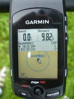
Coordinates.
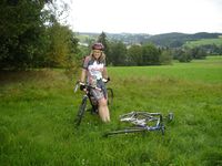
Manu, Wischi and Ritchie and the view from the hashpoint.
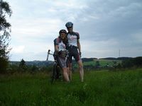
Manu, Reinhard, Wischi and Ritchie at the hashpoint.
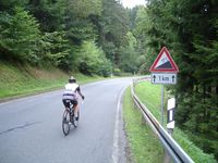
How to love cycling in Frankenwald.


