Difference between revisions of "2009-08-25 47 -65"
imported>Wmcduff (Short plan) |
imported>Wmcduff (First part of expidition.) |
||
| Line 13: | Line 13: | ||
== Location == | == Location == | ||
| − | In South Tetagouche, just south of Sainte Anne Street | + | In South Tetagouche, just south of Sainte Anne Street. (Well, Rose Hill Road, it seems.) |
== Participants == | == Participants == | ||
| Line 25: | Line 25: | ||
== Expedition == | == Expedition == | ||
| + | Well, hair shortened, teeth buffed, lunch consumed, I headed out to try to hit the nearby hash on my day off. It was only a couple of kilometers out of town, just off a road. Finally, and easy geohash in Bathurst! | ||
| − | + | ...Yeah, I should have known better than that. | |
| + | Anyway, I headed up Vanier, and took the turn. A grader was at work on Saint-Andre, the pavement pulled up as they pushed the rocks around. I squeezed by, and turned onto Sainte Anne. Once safely there, I turned on my GPS with 2 km to go to get an idea of how far I left to go. A kilometer and a half passed...and my road ended. | ||
| + | |||
| + | Wait a minute. I looked at Google Maps. There's a road here. It goes all the way through. And, well, there seemed to be. A single lane track continued on. Not wanting to be unable to turn, I parked at the end of the pavement, and continued on by foot from 500m. | ||
| + | |||
| + | A couple of hundred meters later, the road started to get wet. Not unsurprising, really. Probably used for 4x4ing, and there was a lovely pond by the road. Keeping to the edges, I worked further up the road that was beginning to do a convincing imitation of a stream. | ||
| + | |||
| + | And it was getting worse. The little road ponds developed waterstriders and minnows...how bad was this going to get? As I endevoured to keep my feet dry, I heard a voice behind me. A man called out, asking who I was with. I answered no one, and asked if it was private property; it wasn't. Turned out he had called the Department of Transport and was hoping someone would show up. His basement was getting flooded. | ||
| + | |||
| + | I advised I worked for a call center up the road, and was just out here for a walk, and he advised me there was a beaver dam on the road. | ||
| + | |||
| + | (To be continued...) | ||
== Photos == | == Photos == | ||
| − | |||
| − | |||
| − | |||
| − | |||
| − | |||
<gallery perrow="3"> | <gallery perrow="3"> | ||
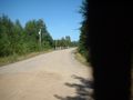
| − | + | Image:2009-08-25 47 -65 End of the road.jpg | Well, that's the end of Saint Anne... | |
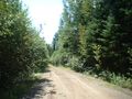
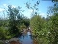
| + | Image:2009-08-25 47 -65 A dirt path.jpg | Hello, Rose Hill Road! Looks passible enough for a stroll... | ||
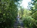
| + | Image:2009-08-25 47 -65 Getting worse.jpg | Perhaps I spoke too soon. | ||
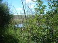
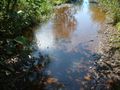
| + | Image:2009-08-25 47 -65 A lovely pond.jpg | What a lovely pond. That must be where the overflow's from. | ||
| + | Image:2009-08-25 47 -65 Water striders.jpg | There are water striders and minnows and... | ||
| + | Image:2009-08-25 47 -65 Dam you beavers.jpg | Beavers. DAM YOU BEAVERS! | ||
</gallery> | </gallery> | ||
| − | |||
| − | |||
| − | |||
| − | |||
| − | |||
[[Category:Expeditions]] | [[Category:Expeditions]] | ||
| − | |||
[[Category:Expeditions with photos]] | [[Category:Expeditions with photos]] | ||
| − | |||
| − | |||
| − | |||
| − | |||
| − | |||
| − | |||
| − | |||
| − | |||
| − | |||
[[Category:Coordinates not reached]] | [[Category:Coordinates not reached]] | ||
| − | |||
[[Category:Not reached - Mother Nature]] | [[Category:Not reached - Mother Nature]] | ||
| − | |||
| − | |||
| − | |||
| − | |||
Revision as of 18:40, 25 August 2009
| Tue 25 Aug 2009 in 47,-65: 47.6138298, -65.7561160 geohashing.info google osm bing/os kml crox |
Location
In South Tetagouche, just south of Sainte Anne Street. (Well, Rose Hill Road, it seems.)
Participants
wmcduff plans to swing by.
Plans
After my dental appointment and haircut, if I have time before board game night, I'll swing by.
Expedition
Well, hair shortened, teeth buffed, lunch consumed, I headed out to try to hit the nearby hash on my day off. It was only a couple of kilometers out of town, just off a road. Finally, and easy geohash in Bathurst!
...Yeah, I should have known better than that.
Anyway, I headed up Vanier, and took the turn. A grader was at work on Saint-Andre, the pavement pulled up as they pushed the rocks around. I squeezed by, and turned onto Sainte Anne. Once safely there, I turned on my GPS with 2 km to go to get an idea of how far I left to go. A kilometer and a half passed...and my road ended.
Wait a minute. I looked at Google Maps. There's a road here. It goes all the way through. And, well, there seemed to be. A single lane track continued on. Not wanting to be unable to turn, I parked at the end of the pavement, and continued on by foot from 500m.
A couple of hundred meters later, the road started to get wet. Not unsurprising, really. Probably used for 4x4ing, and there was a lovely pond by the road. Keeping to the edges, I worked further up the road that was beginning to do a convincing imitation of a stream.
And it was getting worse. The little road ponds developed waterstriders and minnows...how bad was this going to get? As I endevoured to keep my feet dry, I heard a voice behind me. A man called out, asking who I was with. I answered no one, and asked if it was private property; it wasn't. Turned out he had called the Department of Transport and was hoping someone would show up. His basement was getting flooded.
I advised I worked for a call center up the road, and was just out here for a walk, and he advised me there was a beaver dam on the road.
(To be continued...)
Photos
Well, that's the end of Saint Anne...
Hello, Rose Hill Road! Looks passible enough for a stroll...
Perhaps I spoke too soon.
What a lovely pond. That must be where the overflow's from.
There are water striders and minnows and...
Beavers. DAM YOU BEAVERS!


