Difference between revisions of "2009-08-26 48 9"
imported>Ekorren (preliminary report. Will probably be replaced in september.) |
imported>FippeBot m (Location) |
||
| (One intermediate revision by one other user not shown) | |||
| Line 21: | Line 21: | ||
== Gallery == | == Gallery == | ||
| − | + | <gallery> | |
| + | Image:2009-08-26_48_9_Bridge.jpg|Cross that bridge, if you are brave enough. Actually, I almost broke another plank. | ||
| + | Image:2009-08-26_48_9_Hohenurach.jpg|A view on Castle Hohenurach | ||
| + | Image:2009-08-26_48_9_GPS.jpg|Coordinates almost reached | ||
| + | Image:2009-08-26_48_9_Hashpoint.jpg|The hash is up and in there, unreachable. | ||
| + | </gallery> | ||
[[Category:Expeditions]] | [[Category:Expeditions]] | ||
| Line 27: | Line 32: | ||
[[Category:Not reached - Mother Nature]] | [[Category:Not reached - Mother Nature]] | ||
[[Category:Coordinates not reached]] | [[Category:Coordinates not reached]] | ||
| + | {{location|DE|BW|RT}} | ||
Latest revision as of 05:23, 8 August 2019
| Wed 26 Aug 2009 in 48,9: 48.5313907, 9.3749877 geohashing.info google osm bing/os kml crox |
Contents
Location
At the Albtrauf steep slope, where steep isn't only a word about that you need a low gear; near the small road from Dettingen (Erms) to Hülben. 12 m from the road into the forest, so close and yet so far.
Participants
Expedition
Short version (will probably be replaced by a long one in september):
Went there by bike, although I didn't really have the time for it. Took detours, intended and unintended ones, although I really didn't have the time for that. Somehow made my way up (!) to 12 m from the hash, tried to climb from the road into the forest but failed. Changed speed from nasty to insane back, until the bike broke down - 200 m from Metzingen station, 10 min before a train went back. Instead of fixing the bike, carried it to the station and took the train home.
Gallery
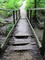
Cross that bridge, if you are brave enough. Actually, I almost broke another plank.
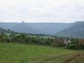
A view on Castle Hohenurach
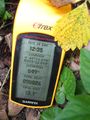
Coordinates almost reached
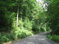
The hash is up and in there, unreachable.


