Difference between revisions of "2009-08-29 45 -122"
imported>Jiml m (First minor draft of report) |
imported>Jiml (Add photos and report) |
||
| Line 14: | Line 14: | ||
== Plans == | == Plans == | ||
| − | I' | + | It was a busy day. I finally made it, as expected, later in the afternoon. I don't think I missed |
| − | + | anyone at 4PM, but maybe they will make a report if they went there. | |
| − | |||
| − | |||
| − | |||
| − | |||
== Expedition == | == Expedition == | ||
| − | I | + | It was a busy day. I actually was close to the hashpoint around noon because we needed a test run |
| − | + | at the vet. But I needed to get to the Farmer's Market, so the venture to the hashpoint needed to wait | |
| − | + | until later in the afternoon. | |
| − | |||
| + | Everything ran long, so I didn't make it to the hashpoint until a long time after 4PM. However, the only | ||
| + | other possible person, [[User:3riador]] was off at school, so not available to join me. | ||
| + | It has been a busy weekend in the Hillsboro area. We've got a Airshow running for 3 days at our | ||
| + | nearby airport, some sort of LPGA golf event near the hashpoint, and a big running event as well. | ||
| + | I managed to dodge around the airshow traffic for most of the day, but apparently the Airshow managed | ||
| + | to disturb the golf event. | ||
| − | + | I drove out to the hashpoint, enjoying the scenery, which was improved by the rain earlier today. The road | |
| + | became smaller as I went, but it was still pretty. As I came around a curve, the GPS reported the hashpoint | ||
| + | getting closer. It dropped to about 170 feet and then started up again. I looked around for a place to park or turn | ||
| + | around. I found a turn around point a couple of farms up the road and returned to a place where I could pull off | ||
| + | the road and walked over. | ||
| + | The hashpoint proved about a hundred feet from the road. However, the field was looking both soggy and | ||
| + | protected by barbed wire. So, I went in search of the owner. An adjacent property pointed me in one | ||
| + | direction, but I didn't find anyone to give me permission. (The neighbor actually thought the owner wouldn't care | ||
| + | since the field had been harvested.) | ||
| − | + | So, no land geohash, but it was a pretty drive. | |
== Photos == | == Photos == | ||
| − | |||
| − | |||
| − | |||
| − | |||
| − | |||
<gallery perrow="3"> | <gallery perrow="3"> | ||
| + | Image:2009-08-29 45 -122-landscape.jpg | Pretty landscape | ||
| + | Image:2009-08-29 45 -122-other-side.jpg | Other side of the road from the hashpoint | ||
| + | Image:2009-08-29 45 -122-hashfield.jpg | Field containing the hashpoint | ||
| + | Image:2009-08-29 45 -122-livestock-a.jpg | View of area and grazers | ||
| − | + | Image:2009-08-29 45 -122-hashpoint.jpg | A different type of hash point. (Look closely at the 3 strands of barbed wire) | |
| + | Image:2009-08-29 45 -122-farm.jpg | Farm near to hashpoint. | ||
| + | Image:2009-08-29 45 -122-livestock-b.jpg | View of area, including some grazers | ||
| + | Image:2009-08-29 45 -122-alpaca.jpg | These alpacas live nearby | ||
| − | |||
| − | |||
| − | |||
| − | |||
| − | |||
| − | |||
| − | |||
| − | |||
| − | |||
| − | |||
| − | |||
| − | |||
| − | |||
| − | |||
| − | |||
| − | |||
| − | |||
| − | |||
| − | |||
| − | |||
| − | |||
| − | |||
| − | |||
| − | |||
| − | |||
| + | </gallery> | ||
[[Category:Expeditions]] | [[Category:Expeditions]] | ||
[[Category:Coordinates not reached]] | [[Category:Coordinates not reached]] | ||
[[Category:Not reached - No public access]][[Category:Expeditions with photos]] | [[Category:Not reached - No public access]][[Category:Expeditions with photos]] | ||
Revision as of 11:22, 30 August 2009
| Sat 29 Aug 2009 in 45,-122: 45.6278569, -122.9720826 geohashing.info google osm bing/os kml crox |
Contents
Location
North Plains, Oregon, USA. In somebody's field, naturally.
Participants
Plans
It was a busy day. I finally made it, as expected, later in the afternoon. I don't think I missed anyone at 4PM, but maybe they will make a report if they went there.
Expedition
It was a busy day. I actually was close to the hashpoint around noon because we needed a test run at the vet. But I needed to get to the Farmer's Market, so the venture to the hashpoint needed to wait until later in the afternoon.
Everything ran long, so I didn't make it to the hashpoint until a long time after 4PM. However, the only other possible person, User:3riador was off at school, so not available to join me.
It has been a busy weekend in the Hillsboro area. We've got a Airshow running for 3 days at our nearby airport, some sort of LPGA golf event near the hashpoint, and a big running event as well. I managed to dodge around the airshow traffic for most of the day, but apparently the Airshow managed to disturb the golf event.
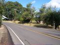
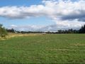
I drove out to the hashpoint, enjoying the scenery, which was improved by the rain earlier today. The road became smaller as I went, but it was still pretty. As I came around a curve, the GPS reported the hashpoint getting closer. It dropped to about 170 feet and then started up again. I looked around for a place to park or turn around. I found a turn around point a couple of farms up the road and returned to a place where I could pull off the road and walked over.
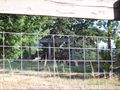
The hashpoint proved about a hundred feet from the road. However, the field was looking both soggy and protected by barbed wire. So, I went in search of the owner. An adjacent property pointed me in one direction, but I didn't find anyone to give me permission. (The neighbor actually thought the owner wouldn't care since the field had been harvested.)
So, no land geohash, but it was a pretty drive.
Photos
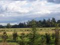
Pretty landscape
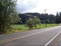
Other side of the road from the hashpoint
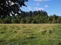
Field containing the hashpoint
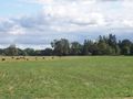
View of area and grazers
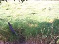
A different type of hash point. (Look closely at the 3 strands of barbed wire)
Farm near to hashpoint.
View of area, including some grazers
These alpacas live nearby


