Difference between revisions of "2009-08-30 49 12"
From Geohashing
imported>Tomcat (New page: {{meetup graticule | map=<map lat="49" lon="12" date="2009-08-30" /> | lat=49 | lon=12 | date=2009-08-30 | graticule_name=Regensburg, Germany | graticule_link=Regensburg, Germany}} == Expe...) |
imported>NWoodruff |
||
| Line 19: | Line 19: | ||
Image:GH 2009-08-30 49 12 Pond HDR.jpg | HDR-picture of the nearby pond | Image:GH 2009-08-30 49 12 Pond HDR.jpg | HDR-picture of the nearby pond | ||
</gallery> | </gallery> | ||
| + | |||
| + | [[Category:Expeditions]] | ||
| + | [[Category:Expeditions with photos]] | ||
| + | [[Category:Coordinates reached]] | ||
Revision as of 21:24, 23 August 2012
| Sun 30 Aug 2009 in Regensburg, Germany: 49.0775160, 12.3233754 geohashing.info google osm bing/os kml crox |
Expedition
The Hashpoint was in a forest almost 1km south of Forstmühle (Forestmill), roughly 18 km NE of Regensburg. Hans and Tomcat went there in the afternoon thus that location would offer the opportunity to go for some so far incompleted Geocaches as well.
Having their car parked next to a pond, the Hashpoint was just a 5-minute-walk up into the hills away. Once having reached the exact spot they took the usual photographs and stood there for a while before they left in search for the scheduled Geocaches.
Photos
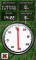
coordinates reached
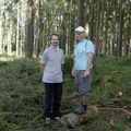
Geohashers at the Hashpoint
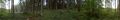
panoramic view at the hash
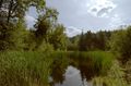
HDR-picture of the nearby pond


