Difference between revisions of "2009-09-04 -38 146"
From Geohashing
imported>Felix Dance |
imported>Felix Dance (Wrote short version - stay tuned for the long one!) |
||
| Line 13: | Line 13: | ||
=== [[User:Felix Dance|Felix Dance]] === | === [[User:Felix Dance|Felix Dance]] === | ||
| + | |||
| + | ==== Short Version ==== | ||
| + | |||
| + | Took the train to Traralgon on Friday after work while on my bike laden with touring gear. After encountering some freaky cows and a power station, I rode up into the hills to camp. Part II of a four day consecutive geohash. [[2009-09-03 -37 145]] is the first and [[2009-09-05 -37 145]] is the next. | ||
| + | |||
| + | ==== Long Version ==== | ||
[http://maps.google.com.au/maps?f=d&source=s_d&saddr=Unknown+street&daddr=-38.220672%C2%B0,+146.553786%C2%B0+to:Shakespeare+St+to:Breed+St+to:W3+Trk+to:W3+Trk+to:Blair+Rd+to:Anderson+Rd+to:Old+Sale+Rd+to:Old+Sale+Rd+to:Beards+Trk+to:-37.958801%C2%B0,+145.888943%C2%B0+to:Tarago+Rd+to:Pioneer+Creek+Rd+to:Yarra+Junction+Noojee+Rd+to:Warburton+Hwy+to:York+Rd+to:Canterbury+Rd+to:Maroondah+Hwy+to:Hawkins+Ave+to:Union+Rd+to:Cotham+Rd+to:Buckingham+St+to:-37.823277,144.979448+to:395+Bay+St,+Port+Melbourne+VIC+3207,+Australia+(Home,+Paint+and+Wallpaper)&hl=en&geocode=Fecguf0dc_67CA%3BFYDMuP0duju8CA%3BFQAXuf0dYh-8CA%3BFSUmuf0dpuq7CA%3BFYNyuv0dDJC6CA%3BFeFxuv0dZ1q6CA%3BFXgduv0dTQK6CA%3BFb0Guv0d5764CA%3BFd0Ouv0duCm3CA%3BFXDbuv0dx6q1CA%3BFbC1u_0divq0CA%3BFW_LvP0drxayCA%3BFRYHvf0dPouxCA%3BFZb1vf0dENywCA%3BFZ8hvv0ddG6wCA%3BFb6Uv_0dD-WrCA%3BFcZUv_0dIEGqCA%3BFTC0vv0drAOnCA%3BFT7zvv0dIsqmCA%3BFfkWv_0d80CmCA%3BFRAdv_0d0BCmCA%3BFf4cv_0dDv6kCA%3BFU4Av_0dspqkCA%3B%3B&mra=dme&mrcr=4&mrsp=23&sz=14&via=2,3,5,6,7,8,9,10,12,14,15,16,17,18,19,20,21,22,23&sll=-37.825989,144.975929&sspn=0.051118,0.077162&ie=UTF8&ll=-37.94528,145.732269&spn=0.81656,1.757813&t=p&z=10 Here's] the Google Maps link to my whole route. Friday's section is between A and C - 25 kms. | [http://maps.google.com.au/maps?f=d&source=s_d&saddr=Unknown+street&daddr=-38.220672%C2%B0,+146.553786%C2%B0+to:Shakespeare+St+to:Breed+St+to:W3+Trk+to:W3+Trk+to:Blair+Rd+to:Anderson+Rd+to:Old+Sale+Rd+to:Old+Sale+Rd+to:Beards+Trk+to:-37.958801%C2%B0,+145.888943%C2%B0+to:Tarago+Rd+to:Pioneer+Creek+Rd+to:Yarra+Junction+Noojee+Rd+to:Warburton+Hwy+to:York+Rd+to:Canterbury+Rd+to:Maroondah+Hwy+to:Hawkins+Ave+to:Union+Rd+to:Cotham+Rd+to:Buckingham+St+to:-37.823277,144.979448+to:395+Bay+St,+Port+Melbourne+VIC+3207,+Australia+(Home,+Paint+and+Wallpaper)&hl=en&geocode=Fecguf0dc_67CA%3BFYDMuP0duju8CA%3BFQAXuf0dYh-8CA%3BFSUmuf0dpuq7CA%3BFYNyuv0dDJC6CA%3BFeFxuv0dZ1q6CA%3BFXgduv0dTQK6CA%3BFb0Guv0d5764CA%3BFd0Ouv0duCm3CA%3BFXDbuv0dx6q1CA%3BFbC1u_0divq0CA%3BFW_LvP0drxayCA%3BFRYHvf0dPouxCA%3BFZb1vf0dENywCA%3BFZ8hvv0ddG6wCA%3BFb6Uv_0dD-WrCA%3BFcZUv_0dIEGqCA%3BFTC0vv0drAOnCA%3BFT7zvv0dIsqmCA%3BFfkWv_0d80CmCA%3BFRAdv_0d0BCmCA%3BFf4cv_0dDv6kCA%3BFU4Av_0dspqkCA%3B%3B&mra=dme&mrcr=4&mrsp=23&sz=14&via=2,3,5,6,7,8,9,10,12,14,15,16,17,18,19,20,21,22,23&sll=-37.825989,144.975929&sspn=0.051118,0.077162&ie=UTF8&ll=-37.94528,145.732269&spn=0.81656,1.757813&t=p&z=10 Here's] the Google Maps link to my whole route. Friday's section is between A and C - 25 kms. | ||
| + | |||
| + | The rest is coming soon... | ||
== Photos == | == Photos == | ||
| Line 26: | Line 34: | ||
Image:Geohash 2009 09 04 -37 146 Traralgon and Yan Yean Power Station.jpg|Traralgon and Yan Yean Power Station | Image:Geohash 2009 09 04 -37 146 Traralgon and Yan Yean Power Station.jpg|Traralgon and Yan Yean Power Station | ||
</gallery> | </gallery> | ||
| + | |||
| + | {{Virgin graticule | ||
| + | |||
| + | | latitude = -38 | ||
| + | | longitude = 146 | ||
| + | | date = 2009-09-04 | ||
| + | | name = [[User:Felix Dance|Felix Dance]] | ||
| + | | image = | ||
| + | |||
| + | }} | ||
| + | |||
| + | {{consecutive geohash | ||
| + | |||
| + | | count = 4 | ||
| + | | latitude = -37 | ||
| + | | longitude = 145 | ||
| + | | date = 2009-09-03 | ||
| + | | name = [[User:Felix Dance|Felix Dance]] | ||
| + | }} | ||
[[Category: Expeditions]] | [[Category: Expeditions]] | ||
[[Category: Expeditions with photos]] | [[Category: Expeditions with photos]] | ||
[[Category: Coordinates reached]] | [[Category: Coordinates reached]] | ||
Revision as of 13:18, 6 September 2009
| Fri 4 Sep 2009 in -38,146: -38.2206720, 146.5537864 geohashing.info google osm bing/os kml crox |
The Place
Just outside Traralgon, on a farm next to the Loy Yang Coal Mine.
Expedition
Felix Dance
Short Version
Took the train to Traralgon on Friday after work while on my bike laden with touring gear. After encountering some freaky cows and a power station, I rode up into the hills to camp. Part II of a four day consecutive geohash. 2009-09-03 -37 145 is the first and 2009-09-05 -37 145 is the next.
Long Version
Here's the Google Maps link to my whole route. Friday's section is between A and C - 25 kms.
The rest is coming soon...
Photos

Fuzzy GPS

Felix at geohash
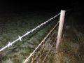
Barbed wire fence
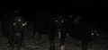
Freaky cows
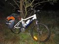
Bike near hashpoint

Yan Yean Power Station

Traralgon and Yan Yean Power Station


Felix Dance earned the Consecutive geohash achievement
|