Difference between revisions of "2009-09-06 -37 145"
imported>Felix Dance (Wrote short version - stay tuned for the long one!) |
imported>Felix Dance m (→Expedition: Added long version heading) |
||
| Line 17: | Line 17: | ||
Getting up from my campsite near Bunyip State Park I rode through remote bushland for most of the day, bush bashing to the very densely forested hash point, then rode home via the Warburton to Lilydale rail trail. Part IV of a four day consecutive geohash. [[2009-09-03 -37 145]] is the first and [[2009-09-05 -37 145]] is the previous one. | Getting up from my campsite near Bunyip State Park I rode through remote bushland for most of the day, bush bashing to the very densely forested hash point, then rode home via the Warburton to Lilydale rail trail. Part IV of a four day consecutive geohash. [[2009-09-03 -37 145]] is the first and [[2009-09-05 -37 145]] is the previous one. | ||
| + | |||
| + | ==== Long Version ==== | ||
[http://maps.google.com.au/maps?f=d&source=s_d&saddr=Unknown+street&daddr=-38.220672%C2%B0,+146.553786%C2%B0+to:Shakespeare+St+to:Breed+St+to:W3+Trk+to:W3+Trk+to:Blair+Rd+to:Anderson+Rd+to:Old+Sale+Rd+to:Old+Sale+Rd+to:Beards+Trk+to:-37.958801%C2%B0,+145.888943%C2%B0+to:Tarago+Rd+to:Pioneer+Creek+Rd+to:Yarra+Junction+Noojee+Rd+to:Warburton+Hwy+to:York+Rd+to:Canterbury+Rd+to:Maroondah+Hwy+to:Hawkins+Ave+to:Union+Rd+to:Cotham+Rd+to:Buckingham+St+to:-37.823277,144.979448+to:395+Bay+St,+Port+Melbourne+VIC+3207,+Australia+(Home,+Paint+and+Wallpaper)&hl=en&geocode=Fecguf0dc_67CA%3BFYDMuP0duju8CA%3BFQAXuf0dYh-8CA%3BFSUmuf0dpuq7CA%3BFYNyuv0dDJC6CA%3BFeFxuv0dZ1q6CA%3BFXgduv0dTQK6CA%3BFb0Guv0d5764CA%3BFd0Ouv0duCm3CA%3BFXDbuv0dx6q1CA%3BFbC1u_0divq0CA%3BFW_LvP0drxayCA%3BFRYHvf0dPouxCA%3BFZb1vf0dENywCA%3BFZ8hvv0ddG6wCA%3BFb6Uv_0dD-WrCA%3BFcZUv_0dIEGqCA%3BFTC0vv0drAOnCA%3BFT7zvv0dIsqmCA%3BFfkWv_0d80CmCA%3BFRAdv_0d0BCmCA%3BFf4cv_0dDv6kCA%3BFU4Av_0dspqkCA%3B%3B&mra=dme&mrcr=4&mrsp=23&sz=14&via=2,3,5,6,7,8,9,10,12,14,15,16,17,18,19,20,21,22,23&sll=-37.825989,144.975929&sspn=0.051118,0.077162&ie=UTF8&ll=-37.94528,145.732269&spn=0.81656,1.757813&t=p&z=10 Here's] the Google Maps link to my whole route. Saturday's section is between D and F - 128 kms. | [http://maps.google.com.au/maps?f=d&source=s_d&saddr=Unknown+street&daddr=-38.220672%C2%B0,+146.553786%C2%B0+to:Shakespeare+St+to:Breed+St+to:W3+Trk+to:W3+Trk+to:Blair+Rd+to:Anderson+Rd+to:Old+Sale+Rd+to:Old+Sale+Rd+to:Beards+Trk+to:-37.958801%C2%B0,+145.888943%C2%B0+to:Tarago+Rd+to:Pioneer+Creek+Rd+to:Yarra+Junction+Noojee+Rd+to:Warburton+Hwy+to:York+Rd+to:Canterbury+Rd+to:Maroondah+Hwy+to:Hawkins+Ave+to:Union+Rd+to:Cotham+Rd+to:Buckingham+St+to:-37.823277,144.979448+to:395+Bay+St,+Port+Melbourne+VIC+3207,+Australia+(Home,+Paint+and+Wallpaper)&hl=en&geocode=Fecguf0dc_67CA%3BFYDMuP0duju8CA%3BFQAXuf0dYh-8CA%3BFSUmuf0dpuq7CA%3BFYNyuv0dDJC6CA%3BFeFxuv0dZ1q6CA%3BFXgduv0dTQK6CA%3BFb0Guv0d5764CA%3BFd0Ouv0duCm3CA%3BFXDbuv0dx6q1CA%3BFbC1u_0divq0CA%3BFW_LvP0drxayCA%3BFRYHvf0dPouxCA%3BFZb1vf0dENywCA%3BFZ8hvv0ddG6wCA%3BFb6Uv_0dD-WrCA%3BFcZUv_0dIEGqCA%3BFTC0vv0drAOnCA%3BFT7zvv0dIsqmCA%3BFfkWv_0d80CmCA%3BFRAdv_0d0BCmCA%3BFf4cv_0dDv6kCA%3BFU4Av_0dspqkCA%3B%3B&mra=dme&mrcr=4&mrsp=23&sz=14&via=2,3,5,6,7,8,9,10,12,14,15,16,17,18,19,20,21,22,23&sll=-37.825989,144.975929&sspn=0.051118,0.077162&ie=UTF8&ll=-37.94528,145.732269&spn=0.81656,1.757813&t=p&z=10 Here's] the Google Maps link to my whole route. Saturday's section is between D and F - 128 kms. | ||
| + | |||
| + | Stay tuned for more! | ||
== Photos == | == Photos == | ||
Revision as of 13:21, 6 September 2009
| Sun 6 Sep 2009 in -37,145: -37.8835241, 145.8030964 geohashing.info google osm bing/os kml crox |
The Place
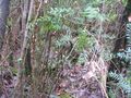
Just to the north of Bunyip State Park, near Powelltown, deep in forest.
Expedition
Felix Dance
Short Version
Getting up from my campsite near Bunyip State Park I rode through remote bushland for most of the day, bush bashing to the very densely forested hash point, then rode home via the Warburton to Lilydale rail trail. Part IV of a four day consecutive geohash. 2009-09-03 -37 145 is the first and 2009-09-05 -37 145 is the previous one.
Long Version
Here's the Google Maps link to my whole route. Saturday's section is between D and F - 128 kms.
Stay tuned for more!
Photos
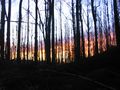
Sunrise
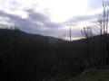
Tarago River valley
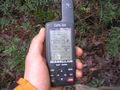
GPS at hashpoint
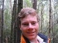
Felix at hashpoint
View north from hashpoint
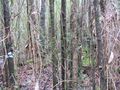
View east from hashpoint
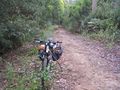
Bike left on track

Felix back at bike after hashing
Bike at Yarra Junction
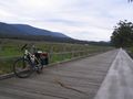
Bike on Warburton Rail Trail
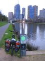
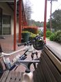
Bike back in city


Felix Dance earned the Bicycle geohash achievement
|
Felix Dance earned the Consecutive geohash achievement
|