Difference between revisions of "2009-09-15 39 -111"
From Geohashing
imported>GarafaJon (→Participants) |
m (per Renaming Proposal) |
||
| (4 intermediate revisions by 3 users not shown) | |||
| Line 1: | Line 1: | ||
| − | |||
| − | |||
| − | |||
| − | |||
{{meetup graticule | {{meetup graticule | ||
| lat=39 | | lat=39 | ||
| Line 8: | Line 4: | ||
| date=2009-09-15 | | date=2009-09-15 | ||
}} | }} | ||
| − | |||
| − | |||
| − | |||
== Location == | == Location == | ||
| − | + | Up on a really cool ridge in the Uinta mountains, south of Provo, Utah. About 9,300 ft. | |
== Participants == | == Participants == | ||
| − | [[User:GarafaJon|GarafaJon]] drove. | + | * [[User:GarafaJon|GarafaJon]] drove. |
| − | [[User:SaraJane|SaraJane]] posed. | + | * [[User:SaraJane|SaraJane]] posed. |
| − | [[User:Spencer|Spencer]] took the pictures. | + | * [[User:Spencer|Spencer]] took the pictures. |
| − | |||
| − | |||
| − | |||
| − | |||
| − | |||
| − | |||
| − | |||
| − | |||
| − | |||
== Photos == | == Photos == | ||
| − | |||
| − | |||
| − | |||
| − | |||
| − | |||
| − | |||
<gallery perrow="3"> | <gallery perrow="3"> | ||
| − | + | Image:2009-09-15 39 -111 track1.jpg | On our way | |
| + | Image:2009-09-15 39 -111 track2.jpg | There! | ||
| + | Image:2009-09-15_39_-111_Sara_Hashing.jpg | SaraJane at the geohash! | ||
</gallery> | </gallery> | ||
| + | == Ribbons == | ||
| + | {{Graticule unlocked | latitude = 39 | longitude = -111 | date = 2009-09-15 | name = SaraJane }} | ||
| − | |||
| − | |||
| − | |||
| − | |||
| − | |||
| − | |||
| − | |||
| − | |||
[[Category:Expeditions with photos]] | [[Category:Expeditions with photos]] | ||
| − | |||
| − | |||
| − | |||
| − | |||
| − | |||
[[Category:Coordinates reached]] | [[Category:Coordinates reached]] | ||
| − | + | [[Category:Expeditions]] | |
| − | + | {{location|US|UT|UT}} | |
| − | |||
| − | |||
| − | |||
| − | |||
| − | |||
| − | |||
| − | [[Category: | ||
| − | |||
| − | |||
| − | |||
| − | {{ | ||
| − | |||
Latest revision as of 06:23, 20 March 2024
| Tue 15 Sep 2009 in 39,-111: 39.8586751, -111.3238955 geohashing.info google osm bing/os kml crox |
Contents
Location
Up on a really cool ridge in the Uinta mountains, south of Provo, Utah. About 9,300 ft.
Participants
Photos
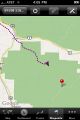
On our way
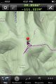
There!
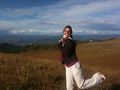
SaraJane at the geohash!


Ribbons
SaraJane earned the Graticule Unlocked Achievement
|