Difference between revisions of "2009-09-15 40 -74"
imported>Knitting Duck |
imported>FippeBot m (Location) |
||
| (5 intermediate revisions by one other user not shown) | |||
| Line 17: | Line 17: | ||
== Participants == | == Participants == | ||
| − | * [[User:Knitting Duck|Knitting Duck]] | + | * [[User:Knitting Duck|Knitting Duck]] and friend |
== Plans == | == Plans == | ||
| − | |||
[[User:Knitting Duck|Knitting Duck]] is going out this afternoon anyway, though not quite in the direction of the hash. It's maybe a fifteen minute detour. Since it looks like it's just in a parking lot, it should be easy enough to drive up, snap a few pictures, and head out again. | [[User:Knitting Duck|Knitting Duck]] is going out this afternoon anyway, though not quite in the direction of the hash. It's maybe a fifteen minute detour. Since it looks like it's just in a parking lot, it should be easy enough to drive up, snap a few pictures, and head out again. | ||
== Expedition == | == Expedition == | ||
| + | We found the place easily enough, since it's in a familiar location. It turned out to be the place where school busses go when they aren't out being school busses. Since it was late afternoon, most of the busses were out and the place was largely deserted. | ||
| + | We wandered around, over to the spot in question, and then back to our cars. We didn't want to stay very long because even though there weren't signs posted it seemed like a bad idea to loiter in a place where school busses live. After snapping some photographic evidence we headed out. | ||
== Photos == | == Photos == | ||
| Line 34: | Line 35: | ||
--> | --> | ||
<gallery perrow="3"> | <gallery perrow="3"> | ||
| − | + | Image:2009-09-15_40_-74_coordinates1.jpg | Photographic evidence of coordinates reached. | |
| + | Image:2009-09-15_40_-74_thespot.jpg | The spot. Note the school busses in the background. | ||
| + | Image:2009-09-15_40_-74_duckandsign1.jpg | The Knitting Duck, GPS device, and "THE INTERNET WAS HERE" sign for the day's hash. | ||
</gallery> | </gallery> | ||
| − | |||
| − | |||
| − | |||
| − | |||
[[Category:Expeditions]] | [[Category:Expeditions]] | ||
[[Category:Expeditions with photos]] | [[Category:Expeditions with photos]] | ||
[[Category:Coordinates reached]] | [[Category:Coordinates reached]] | ||
| − | + | {{location|US|NJ|MR}} | |
| − | |||
| − | |||
| − | |||
| − | |||
| − | |||
| − | |||
| − | |||
| − | |||
Latest revision as of 05:48, 8 August 2019
| Tue 15 Sep 2009 in 40,-74: 40.8586751, -74.3238955 geohashing.info google osm bing/os kml crox |
Location
40.858675°, -74.323896°... otherwise known as a parking lot off Bloomfield Avenue near Route 46 in (what I think at that point is) Fairfield, NJ.

Participants
- Knitting Duck and friend
Plans
Knitting Duck is going out this afternoon anyway, though not quite in the direction of the hash. It's maybe a fifteen minute detour. Since it looks like it's just in a parking lot, it should be easy enough to drive up, snap a few pictures, and head out again.
Expedition
We found the place easily enough, since it's in a familiar location. It turned out to be the place where school busses go when they aren't out being school busses. Since it was late afternoon, most of the busses were out and the place was largely deserted.
We wandered around, over to the spot in question, and then back to our cars. We didn't want to stay very long because even though there weren't signs posted it seemed like a bad idea to loiter in a place where school busses live. After snapping some photographic evidence we headed out.
Photos
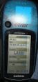
Photographic evidence of coordinates reached.
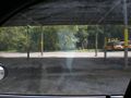
The spot. Note the school busses in the background.
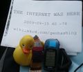
The Knitting Duck, GPS device, and "THE INTERNET WAS HERE" sign for the day's hash.


