Difference between revisions of "2009-10-01 36 -106"
imported>Redaragorn |
|||
| Line 32: | Line 32: | ||
</gallery> | </gallery> | ||
| + | {{Virgin graticule | latitude = 36| longitude = -106 | date = 2009-10-01 | name = [[User:Redaragorn|Redaragorn]] }} | ||
[[Category:Expeditions]] | [[Category:Expeditions]] | ||
[[Category:Coordinates reached]] | [[Category:Coordinates reached]] | ||
Revision as of 04:22, 2 October 2009
| Thu 1 Oct 2009 in 36,-106: 36.2390778, -106.8599923 geohashing.info google osm bing/os kml crox |
Location
A small field just off the highway in the upper Rio Gallina valley.
Participants
Plans
So this was the one I was more looking forward to for the day. It was a virgin graticule and very close to a road (a *paved* one, at that!), but I was a little concerned that it might be on private property. Guess I'd just have to get there to find out...
Expedition
We drove north through Cuba, then turned onto SR-96 to head around the mountains and get to the hash point. I missed the tiny dirt turn-off to the hash on my first time past, but went back and caught it. There was a gate on the road, like I expected, but I didn't expect to find it half-open. It was signed for a game management unit, but didn't say anything about No Trespassing--since it was partially open (and didn't even have a lock) I just finished the job and let myself in. I parked the car a whole 60 ft from the hash. The three year old had fallen asleep on the drive up, so I left him sleeping in his seat and went to find the hash. It turns out that it was over a barbed wire fence into someone's property next door. I looked, but didn't see any No Trespassing signs, so I jumped the fence and caught the hash. Even still, I didn't hang out for too long. Got the pics and headed back to the car without the boy even waking up. We headed out for another couple of short hikes up in the general vicinity, making it a very fine day overall.
Pictures
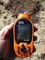
GPS coordinates for this one.

Had to come up with another goofy grin--think I did OK.
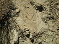
Scratches in the dirt.


