Difference between revisions of "2009-10-01 52 -7"
From Geohashing
imported>JRK (New page: {{meetup graticule | lat=52 | lon=-7 | date=2009-10-01 | graticule_name=Waterford, Ireland | graticule_link=Waterford, Ireland}} == About == The hash point was just few kilometres west of...) |
m |
||
| (One intermediate revision by one other user not shown) | |||
| Line 37: | Line 37: | ||
}} | }} | ||
| + | [[Category:Expeditions]] | ||
[[Category:Expeditions with photos]] | [[Category:Expeditions with photos]] | ||
[[Category:Coordinates reached]] | [[Category:Coordinates reached]] | ||
| + | {{location|IE|M|WD}} | ||
Latest revision as of 17:54, 19 April 2021
| Thu 1 Oct 2009 in Waterford, Ireland: 52.2291655, -7.1952627 geohashing.info google osm bing/os kml crox |
About
The hash point was just few kilometres west of the place I live [Waterford], so even though I was just after work, I decided to go for a nice [hopefuly] walk.
Expedition
The hash was [surprise surprise] in the middle of the field, the walk [+10km] was uneventful, so just enjoy few pictures I made on the way.
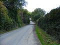
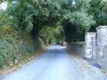
Typical Irish road.
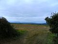
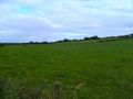
Typical Irish field.
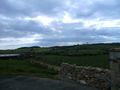
Typical Irish hills.
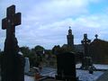
Typical Irish church + graveyard.
Typical Irish greeen tunnel.

Typical Irish Lisbon Yes/No referendum campaign. Yes, Europe is making small kids cry. Bad Europe, bad!
Unique Irish hash field - only one per graticule every day!


JRK earned the Land geohash achievement
|
JRK earned the Walk geohash Achievement
|