Difference between revisions of "2009-10-13 41 -90"
imported>Zentiggr (→Participants) |
m (per Renaming Proposal) |
||
| (4 intermediate revisions by 3 users not shown) | |||
| Line 19: | Line 19: | ||
== Plans == | == Plans == | ||
| + | Yeah, right... Found out early in the afternoon that an after-work appointment would be nearby, and that today's hash would be right near my appointment. Coincidence? :-) | ||
== Expedition == | == Expedition == | ||
| + | Easy enough to stop for a few minutes along the way. Found a reasonable parking lot at the end of a stretch of gravel road, and concrete paths off into the woods. Still distinct enough to follow on my Centro's Google Maps. | ||
| − | + | A while later, after some puddle jumping, I approached the foot bridge over the impending creek. Not planning on a long stop, I looked around for the best landmarks to photograph for the "unique enough to triangulate well" plan... The footbridge is the best, a nearby riverside gazebo the next best, and the third photo being the patch of loose waterlogged brush that _IS_ the hashpoint to within a couple of feet. | |
| + | ... and an uneventful hike back through the woods, into the truck, off into the sunset... or home, anyway. | ||
== Photos == | == Photos == | ||
| − | |||
<gallery perrow="4"> | <gallery perrow="4"> | ||
| − | Image:2009- | + | Image:2009-10-13 41 -90 001.jpg | The footbridge NE of the point |
| − | Image:2009- | + | Image:2009-10-13 41 -90 002.jpg | Yes, this really is a gazebo under the river glare overexposure... |
| + | Image:2009-10-13 41 -90 003.jpg | Brown = paydirt! | ||
</gallery> | </gallery> | ||
| − | |||
| − | |||
| − | |||
| − | |||
| − | |||
| − | |||
| − | |||
| − | |||
| − | |||
| − | |||
[[Category:Expeditions]] | [[Category:Expeditions]] | ||
| − | |||
[[Category:Expeditions with photos]] | [[Category:Expeditions with photos]] | ||
| − | |||
[[Category:Expedition without GPS]] | [[Category:Expedition without GPS]] | ||
| − | |||
| − | |||
[[Category:Coordinates reached]] | [[Category:Coordinates reached]] | ||
| − | |||
| − | + | {{land geohash | |
| − | + | | latitude = 41 | |
| − | -- | + | | longitude = -90 |
| − | + | | date = 2009-10-13 | |
| − | + | | name = Zentiggr | |
| − | + | }} | |
| − | + | ||
| − | -- | + | {{Graticule unlocked |
| + | | latitude = 41 | ||
| + | | longitude = -90 | ||
| + | | date = 2009-10-13 | ||
| + | | name = Zentiggr | ||
| + | }} | ||
| + | {{location|US|IA|SC}} | ||
Latest revision as of 06:22, 20 March 2024
| Tue 13 Oct 2009 in 41,-90: 41.5556386, -90.4320180 geohashing.info google osm bing/os kml crox |
Location
Pigeon Creek Park, Bettendorf, IA
Participants
Plans
Yeah, right... Found out early in the afternoon that an after-work appointment would be nearby, and that today's hash would be right near my appointment. Coincidence? :-)
Expedition
Easy enough to stop for a few minutes along the way. Found a reasonable parking lot at the end of a stretch of gravel road, and concrete paths off into the woods. Still distinct enough to follow on my Centro's Google Maps.
A while later, after some puddle jumping, I approached the foot bridge over the impending creek. Not planning on a long stop, I looked around for the best landmarks to photograph for the "unique enough to triangulate well" plan... The footbridge is the best, a nearby riverside gazebo the next best, and the third photo being the patch of loose waterlogged brush that _IS_ the hashpoint to within a couple of feet.
... and an uneventful hike back through the woods, into the truck, off into the sunset... or home, anyway.
Photos
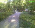
The footbridge NE of the point
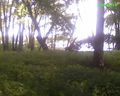
Yes, this really is a gazebo under the river glare overexposure...
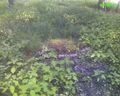
Brown = paydirt!


Zentiggr earned the Land geohash achievement
|
Zentiggr earned the Graticule Unlocked Achievement
|