2009-10-18 60 22
| Sun 18 Oct 2009 in Turku: 60.4945374, 22.2894258 geohashing.info google osm bing/os kml crox |
About
The location was close to an industrial area of Urusvuori in Turku. Although there is some industry in the area, the hashpoint landed on a nice patch of forest conviniently 10 meters from the fence. Successfully reached by Suurnesu.
Expedition
I wasn't quite sure if the are can be reached because it was so close to some factory / warehouse. I left my car at the end of Telekatu, approximately 250 meters south from the hashpoint. There was a good trail leading to the area. On my way, I noticed some nice surprises! There were two massive erratic boulders on the way (N 60° 29.672 E 22° 17.270 and N 60° 29.626 E 22° 17.235). I took some pictures and continued my journey towards the zero point.
The zero point was quite close to the fence but fortunately on the right side. There was a small spruce next to the spot. After takin the official geohashing pictures, I returned to the car. This time I took a path which was close to the industrial area. The path was very nice, it led me through young spruces and the smell of wet forest was very nice and strong.
For me, this was the nicest geohash so far!
-- Suurnesu
Photos
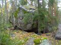
There were two erratic boulders on the way. This was the first one.
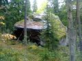
Another erratic boulder, this one was bigger, approximately 4,5 meters tall.
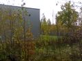
Fortunately the hash point was on the right side of the fence
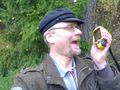
Soooo happy again after another succesful hunt
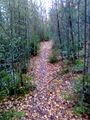
This path took me from the haspoint to the parking place.


