Difference between revisions of "2009-10-25 -33 18"
imported>Warpeddragon m (→Expedition) |
m (per Renaming Proposal) |
||
| (7 intermediate revisions by 2 users not shown) | |||
| Line 21: | Line 21: | ||
== Expedition == | == Expedition == | ||
| − | This was my first attempting at geohashing. This afternoon a friend and I decided that we should go for a drive to get out of our houses. Our initial plan was to drive down south towards [http://en.wikipedia.org/wiki/Muizenberg | + | This was my first attempting at geohashing. This afternoon a friend and I decided that we should go for a drive to get out of our houses. Our initial plan was to drive down south towards [http://en.wikipedia.org/wiki/Muizenberg Muizenberg] but just before I left to fetch them I had a quick look to see where today's hashpoint would be and was gob-smacked to see it was on dry land and near a place I knew. So quickly I took a photo of the coordinates and set off to fetch friend. After picking up some supplies and consulting a map, we decided we would first head towards Melkbosstrand along the beach roads, and then go past the hashpoint on our way home. |
| − | After a lovely day along the beach we headed inland towards the hashpoint following the trustworthy voice of my phone's GPS... which decided that "Turn in 150m" and "Turn now" could be said straight after each other and we had to do a 7km detour to get to the point. Finally the phone said we had reached our destination... but the hashpoint was still | + | After a lovely day along the beach we headed inland towards the hashpoint following the trustworthy voice of my phone's GPS... which decided that "Turn in 150m" and "Turn now" could be said straight after each other and we had to do a 7km detour to get to the point. Finally the phone said we had reached our destination... but the hashpoint was still +-100 meters away into a field surrounded by barb-wire. Not wanting to go jumping fences and possibly trespassing I took some photos and was going to call this a close call. |
| − | On our drive back I suddenly noticed a small sandy road leading towards the field where the hashpoint was with no gate, or any signs. Taking a chance that I might get closer we took a drive down this windy sandy road until we were | + | On our drive back I suddenly noticed a small sandy road leading towards the field where the hashpoint was with no gate, or any signs. Taking a chance that I might get closer we took a drive down this windy sandy road until we were parallel where we were previously but now inside the fence. Leaving my friend in the car (they didn't have proper walking shoes) I walked the short distance following my phone. Once it told me I had "Arrived", I then tried to get the best reading with my phone but the trees made this difficult. After a bit of back and too walking I got the coordinates aligned best I could within 20m accuracy. |
After taking a couple more photo's we headed back to Cape Town via the N7 highway. | After taking a couple more photo's we headed back to Cape Town via the N7 highway. | ||
| Line 36: | Line 36: | ||
Image:2009-##-## ## ## Beta.jpg | Witty Comment | Image:2009-##-## ## ## Beta.jpg | Witty Comment | ||
--> | --> | ||
| − | <gallery perrow=" | + | <gallery perrow="3"> |
| + | Image:2009-10-25 -33 18 tree lined road.jpg | Beautiful tree-lined road alongside hashpoint area | ||
| + | Image:2009-10-25 -33 18 looking over the fence.jpg | Hashpoint is amongst the trees | ||
| + | Image:2009-10-25 -33 18 100m away.jpg | Close, but not close enough | ||
| + | Image:2009-10-25 -33 18 mini forest.jpg | Mini-forest "hiding" the hashpoint | ||
| + | Image:2009-10-25 -33 18 phone arrived.jpg | Phone says I had arrived | ||
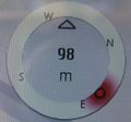
| + | Image:2009-10-25 -33 18 phone coords.jpg | Coordinates on the phone (with some rounding) | ||
| + | </gallery> | ||
| − | + | == Ribbons == | |
| + | |||
| + | {{Graticule unlocked | ||
| + | |||
| + | | latitude = -33 | ||
| + | | longitude = 18 | ||
| + | | date = 2009-10-25 | ||
| + | | name = Warpeddragon | ||
| + | }} | ||
| − | |||
| − | |||
| − | |||
| − | |||
| − | |||
[[Category:Expeditions]] | [[Category:Expeditions]] | ||
| − | |||
[[Category:Expeditions with photos]] | [[Category:Expeditions with photos]] | ||
| − | |||
| − | |||
| − | |||
| − | |||
| − | |||
[[Category:Coordinates reached]] | [[Category:Coordinates reached]] | ||
| − | + | [[Category:Land geohash achievement]] | |
| − | + | {{location|ZA|WC}} | |
| − | |||
| − | |||
| − | |||
| − | |||
| − | |||
| − | |||
| − | [[Category: | ||
| − | |||
Latest revision as of 06:21, 20 March 2024
| Sun 25 Oct 2009 in -33,18: -33.7392029, 18.5315647 geohashing.info google osm bing/os kml crox |
Location
A field alongside a road joining Melkbosstrand Rd and the N7, 8km east of Melkbosstrand
Participants
- Warpeddragon plus a friend
Plans
None :)
Expedition
This was my first attempting at geohashing. This afternoon a friend and I decided that we should go for a drive to get out of our houses. Our initial plan was to drive down south towards Muizenberg but just before I left to fetch them I had a quick look to see where today's hashpoint would be and was gob-smacked to see it was on dry land and near a place I knew. So quickly I took a photo of the coordinates and set off to fetch friend. After picking up some supplies and consulting a map, we decided we would first head towards Melkbosstrand along the beach roads, and then go past the hashpoint on our way home.
After a lovely day along the beach we headed inland towards the hashpoint following the trustworthy voice of my phone's GPS... which decided that "Turn in 150m" and "Turn now" could be said straight after each other and we had to do a 7km detour to get to the point. Finally the phone said we had reached our destination... but the hashpoint was still +-100 meters away into a field surrounded by barb-wire. Not wanting to go jumping fences and possibly trespassing I took some photos and was going to call this a close call.
On our drive back I suddenly noticed a small sandy road leading towards the field where the hashpoint was with no gate, or any signs. Taking a chance that I might get closer we took a drive down this windy sandy road until we were parallel where we were previously but now inside the fence. Leaving my friend in the car (they didn't have proper walking shoes) I walked the short distance following my phone. Once it told me I had "Arrived", I then tried to get the best reading with my phone but the trees made this difficult. After a bit of back and too walking I got the coordinates aligned best I could within 20m accuracy.
After taking a couple more photo's we headed back to Cape Town via the N7 highway.
Photos
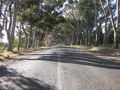
Beautiful tree-lined road alongside hashpoint area
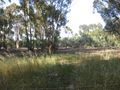
Hashpoint is amongst the trees
Close, but not close enough
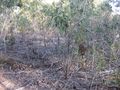
Mini-forest "hiding" the hashpoint
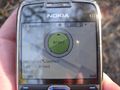
Phone says I had arrived
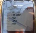
Coordinates on the phone (with some rounding)


Ribbons
Warpeddragon earned the Graticule Unlocked Achievement
|