Difference between revisions of "2009-11-01 49 10"
imported>Danatar (Danatar's report) |
imported>Danatar (+pictures) |
||
| Line 3: | Line 3: | ||
| lon=10 | | lon=10 | ||
| date=2009-11-01 | | date=2009-11-01 | ||
| − | }} | + | }}__NOTOC__ |
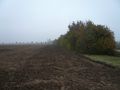
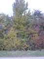
Today's location is near a hedge at the edge of a plowed field, near ''Gut Seligenstadt'' (Seligenstadt manor), belonging to Prosselsheim. | Today's location is near a hedge at the edge of a plowed field, near ''Gut Seligenstadt'' (Seligenstadt manor), belonging to Prosselsheim. | ||
| Line 25: | Line 25: | ||
==Images== | ==Images== | ||
<gallery> | <gallery> | ||
| + | Image:2009-11-01_49_10_hedge1.jpg|Not far now... | ||
| + | Image:2009-11-01_49_10_obstacle.jpg|...almost there, but... | ||
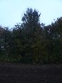
| + | Image:2009-11-01_49_10_hedge2.jpg|...there is a hedge in my way! | ||
Image:2009-11-01_49_10_bags.JPG|Being the clever man that he is... | Image:2009-11-01_49_10_bags.JPG|Being the clever man that he is... | ||
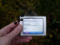
Image:2009-11-01_49_10_gps.JPG|The fields make it so easy. | Image:2009-11-01_49_10_gps.JPG|The fields make it so easy. | ||
| + | Image:2009-11-01 49 10 d gps.jpg|There! | ||
| + | Image:2009-11-01_49_10_hedge3.jpg|On the correct side of the hedge now. | ||
| + | Image:2009-11-01_49_10_stoopidgrins.jpg|Coordinates reached | ||
Image:2009-11-01_49_10_danatar.JPG|That's one small geohash for a man... | Image:2009-11-01_49_10_danatar.JPG|That's one small geohash for a man... | ||
| + | Image:2009-11-01_49_10_moon.jpg|MOOOOOOOOOOOOOON! | ||
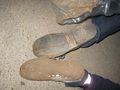
Image:2009-11-01_49_10_feet.JPG|Being the clever man that <i>he</i> is... | Image:2009-11-01_49_10_feet.JPG|Being the clever man that <i>he</i> is... | ||
Image:2009-11-01 49 10 path.JPG|Dude, Where's My Path? | Image:2009-11-01 49 10 path.JPG|Dude, Where's My Path? | ||
Revision as of 21:08, 3 November 2009
| Sun 1 Nov 2009 in 49,10: 49.8439523, 10.0992964 geohashing.info google osm bing/os kml crox |
Today's location is near a hedge at the edge of a plowed field, near Gut Seligenstadt (Seligenstadt manor), belonging to Prosselsheim.
Country: Germany; state: Bayern (Bavaria, EU:DE:BY); administrative region: Unterfranken; district: Würzburg rural district
Participants
- Danatar
- user:thepiguy (multihash part 2)
Expedition
Danatar
After work (yes, I know it's Sunday) Danatar was already driving towards the hashpoint when at 15:45 he finally succeeded in contacting thepiguy. thepiguy announced he would need about one hour fifteen minutes to reach the hashpoint, so Danatar drove really slow (80 km/h = 50 mph) and tried to enjoy the scenery. Nevertheless he was near the hashpoint at quarter past 4. Danatar walked the last 300 metres towards the hashpoint. From the satellite view he knew that a hedge was growing between the track and the hashpoint. There was no spare room between the hedge and the field and Danatar didn't want to get his shoes dirty so he stayed on the track. That way he came within 0.4 seconds (12 metres) of the hashpoint, then the impenetrable hedge stopped him. Danatar continued along the hedge, but from the other end the field also reached up to the hedge. He walked back to the car and waited for thepiguy.
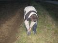
thepiguy arrived at 5 pm and they both walked to the hashpoint. Danatar put bags over his shoes and they walked over the field to the hashpoint, sinking into the loose soil with every step. Moon-visiting astronaut feeling. After reaching the spot they walked back to their modes of transport. Danatar just slipped out of the bags while thepiguy took a while to clean his shoes, then they parted, each one taking a different way home.
thepiguy
... did this one by bike. And should have brought a better light with him.
Images
Not far now...
...almost there, but...
...there is a hedge in my way!
Being the clever man that he is...
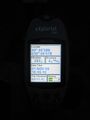
The fields make it so easy.
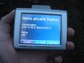
There!
On the correct side of the hedge now.
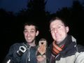
Coordinates reached

That's one small geohash for a man...

MOOOOOOOOOOOOOON!
Being the clever man that he is...

Dude, Where's My Path?


