Difference between revisions of "2009-11-29 46 7"
imported>Crox (changed categories, added picture) |
imported>Thepiguy (+Stuff) |
||
| Line 9: | Line 9: | ||
*[[user:thepiguy|thepiguy]] | *[[user:thepiguy|thepiguy]] | ||
| − | == | + | ==Expedition== |
| − | + | thepiguy and crox both set out from their respective places of being at 7:10 in the morning with thepiguy headed towards Bern and crox heading towards thepiguy. In Lausanne crox boarded thepiguy's train and numerous graphs began to rearrange themselves! In Bern they switched trains and headed to Interlaken where they switched trains again before arriving in Lauterbrunnen. | |
| − | + | Their altitude was now 795m, but seeing as that wouldn't quite do for the days adventure, they took the cable car up to the Grütschalp station at an altitude of 1486m. As the large crowd of tourists departed on the train to Müren, thepiguy and crox began the real adventure. The trail was steep but well kept and marked. They initially headed farther and farther from the geohash until they found the correct trail that would take them to withing a few hundred meters of the coordinates. But let's face it, when are the final few hundred meters ever the easiest? | |
| − | + | The situation was as follows: the linear distance remaining (as read by thepiguy's GPS) was around 150m, the vertical distance remaining (as estimated from crox's map) was around 150m and directly between them and the geohash was large ice covered rock cliff. | |
| − | |||
| − | |||
| − | |||
| − | |||
| − | |||
| − | |||
| − | |||
| − | + | thepiguy led the way as they stumbled up the steep mountain, hoping to circle around the cliff from the north. The ground was covered in small rocks, and the footing was poor, but they made it about 75m further. From there the terrain got even steeper and they were forced to use the frozen snow, small plants and mountain goat tracks as hand holds. At 25m to the coordinates they crawled their way into a large clump of bushes ("At least we have something to hold onto now!") All was not lost, however, as at 15 meters to go they emerged from the bushes to find the coordinates directly in front of them and right on top of a gigantic metal avalanche barrier. Avalanche barriers weren't exactly designed with a geohashers perseverance in mind, but compared to their previous terrain, it was like finding a yellow brick road! | |
| − | |||
| − | + | The two geohashers shimmied along the steel girders (well thepiguy shimmied, crox had no problems just walking like a normal person) and just like that they were there! The final altitude was 1946 meters above sea level. The usual celebration ensued followed by a short discussion of how on earth they were going to get down. | |
| − | |||
| − | + | The easiest decent method turned out to be walking along the barriers then sliding down the mountain until you were (hopefully) stopped by the next one. Once reunited with the trail, they proceeded to try and find a shorter way back. Their return route was indeed shorter, but mainly because they kept loosing the trail and heading straight down the side of the mountain. | |
| − | |||
| − | |||
| − | Crox | + | After returning to civilization, Crox spent the rest of the day giving thepiguy a tour of various Swiss towns! |
| − | + | ==Images== | |
| + | A short video made on the way down the mountain is posted on [http://www.youtube.com/watch?v=wO7PjpTFB_M youtube!] Hang on tight! | ||
| − | + | More photos to come later! | |
| − | + | <gallery> | |
| − | + | Image:2009-11-29_46_7_train.JPG|Two geohashers meet on a train. | |
| − | + | Image:2009-11-29_46_7_cable.JPG|The cable car up from Lauterbrunnen. | |
| + | Image:2009-11-29_46_7_hiking.JPG|The journey begins! | ||
| + | Image:2009-11-29_46_7_view.JPG|Beautiful much? | ||
| + | Image:2009-11-29_46_7_up.JPG|Time to leave the trail behind. | ||
| + | Image:2009-11-29_46_7_hash.JPG|The last few meters! | ||
| + | Image:2009-11-29_46_7_crox_pi_hash.jpg|Success! | ||
| + | Image:2009-11-29_46_7_gps.JPG|Pi Guy proof! | ||
| + | Image:2009-11-29_46_7_crox.JPG|thepiguy's hastily made "card." | ||
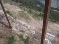
| + | Image:2009-11-29_46_7_down.JPG|Heading back down slope. The cable car station and Lauterbrunnen are visible. | ||
| + | Image:2009-11-29 46 7 trail.JPG|There's our trail... now how do we get to it?! | ||
| + | </gallery> | ||
| Line 48: | Line 48: | ||
[[Category:Coordinates reached]] | [[Category:Coordinates reached]] | ||
[[Category:Expeditions with photos]] | [[Category:Expeditions with photos]] | ||
| + | [[Category:Expeditions with videos]] | ||
Revision as of 21:38, 2 December 2009
| Sun 29 Nov 2009 in 46,7: 46.5976188, 7.8810403 geohashing.info google osm bing/os kml crox |
Participants
Expedition
thepiguy and crox both set out from their respective places of being at 7:10 in the morning with thepiguy headed towards Bern and crox heading towards thepiguy. In Lausanne crox boarded thepiguy's train and numerous graphs began to rearrange themselves! In Bern they switched trains and headed to Interlaken where they switched trains again before arriving in Lauterbrunnen.
Their altitude was now 795m, but seeing as that wouldn't quite do for the days adventure, they took the cable car up to the Grütschalp station at an altitude of 1486m. As the large crowd of tourists departed on the train to Müren, thepiguy and crox began the real adventure. The trail was steep but well kept and marked. They initially headed farther and farther from the geohash until they found the correct trail that would take them to withing a few hundred meters of the coordinates. But let's face it, when are the final few hundred meters ever the easiest?
The situation was as follows: the linear distance remaining (as read by thepiguy's GPS) was around 150m, the vertical distance remaining (as estimated from crox's map) was around 150m and directly between them and the geohash was large ice covered rock cliff.
thepiguy led the way as they stumbled up the steep mountain, hoping to circle around the cliff from the north. The ground was covered in small rocks, and the footing was poor, but they made it about 75m further. From there the terrain got even steeper and they were forced to use the frozen snow, small plants and mountain goat tracks as hand holds. At 25m to the coordinates they crawled their way into a large clump of bushes ("At least we have something to hold onto now!") All was not lost, however, as at 15 meters to go they emerged from the bushes to find the coordinates directly in front of them and right on top of a gigantic metal avalanche barrier. Avalanche barriers weren't exactly designed with a geohashers perseverance in mind, but compared to their previous terrain, it was like finding a yellow brick road!
The two geohashers shimmied along the steel girders (well thepiguy shimmied, crox had no problems just walking like a normal person) and just like that they were there! The final altitude was 1946 meters above sea level. The usual celebration ensued followed by a short discussion of how on earth they were going to get down.
The easiest decent method turned out to be walking along the barriers then sliding down the mountain until you were (hopefully) stopped by the next one. Once reunited with the trail, they proceeded to try and find a shorter way back. Their return route was indeed shorter, but mainly because they kept loosing the trail and heading straight down the side of the mountain.
After returning to civilization, Crox spent the rest of the day giving thepiguy a tour of various Swiss towns!
Images
A short video made on the way down the mountain is posted on youtube! Hang on tight!
More photos to come later!
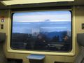
Two geohashers meet on a train.
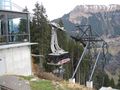
The cable car up from Lauterbrunnen.
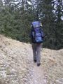
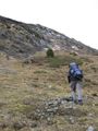
The journey begins!
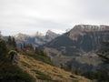
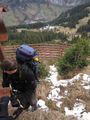
Beautiful much?
Time to leave the trail behind.
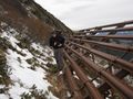
The last few meters!

Success!
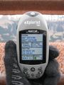
Pi Guy proof!

thepiguy's hastily made "card."
Heading back down slope. The cable car station and Lauterbrunnen are visible.
There's our trail... now how do we get to it?!


