Difference between revisions of "2009-12-05 48 11"
imported>Harleydavidsonandy (→Harleydavidsonandy) |
imported>Harleydavidsonandy (→Harleydavidsonandy) |
||
| Line 23: | Line 23: | ||
<gallery perrow="2"> | <gallery perrow="2"> | ||
Image:2009-12-05 48-11 HP.jpg|HP at the rotten logs | Image:2009-12-05 48-11 HP.jpg|HP at the rotten logs | ||
| − | Image:2009-12-05 48-11 | + | Image:2009-12-05 48-11 timberjack.jpg|Impressive Timberjack harvester |
| − | Image:2009- | + | Image:2009-12-05 48-11 path.jpg|path along the paddock |
| − | Image:2009- | + | Image:2009-12-05 48-11 deer.jpg|deer |
</gallery> | </gallery> | ||
Revision as of 14:17, 5 December 2009
| Sat 5 Dec 2009 in Nettelkofen: 48.0580557, 11.9298404 geohashing.info google osm bing/os kml crox |
About
South east of Pötting, close to rotten logs, not far from a deer paddock. Link to the location
Expeditions
Harleydavidsonandy
After buying a Christmas tree, my daughter and I decided to go for this close by Hash point. We parked our car in Nettelkofen and took the path towards west. The walking distance was about 1,5km, which is a perfect distance for a Saturday afternoon. Whilst making our way toward the HP, we passed a huge green Timberjack harvester, unfortunately not in use today. I would have loved to see one of these monsters in action. The HP is about 50m off the forest path, and accidentally exactly where a pile of rotten logs is. About 100m further towards Pötting, we found a deer paddock with quite a lot deer in it. A nice extra for or me and my daughter! We enjoyed our walk very much - Thanx XKCD for taking us out. Reached around 13:50
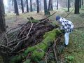
HP at the rotten logs
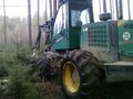
Impressive Timberjack harvester
- 2009-12-05 48-11 path.jpg
path along the paddock
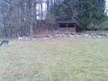
deer


