Difference between revisions of "2010-01-13 49 10"
imported>Dawidi m (+template and basic categories) |
imported>FippeBot m (Location) |
||
| (2 intermediate revisions by one other user not shown) | |||
| Line 3: | Line 3: | ||
| lon=10 | | lon=10 | ||
| date=2010-01-13 | | date=2010-01-13 | ||
| − | }} | + | | graticule_name=Bamberg |
| + | | graticule_link=Bamberg, Germany | ||
| + | }}__NOTOC__ | ||
| + | == Location == | ||
| + | |||
| + | Today's location is in a snow-covered field near Kürnach, near Würzburg. | ||
| + | |||
| + | Country: Germany; state: Bayern (Bavaria, EU:DE:BY); administrative region: Unterfranken; district: Würzburg rural district | ||
| + | |||
| + | Weather: night, minimal snowfall, about -12°C | ||
| + | |||
| + | |||
| + | == Expedition== | ||
| + | ===[[User:Danatar|Danatar]]=== | ||
COOLD! COLD! COOOOOOLD! But coordinates reached. Report next week. - Danatar 08:45, 13 January 2010 (UTC) | COOLD! COLD! COOOOOOLD! But coordinates reached. Report next week. - Danatar 08:45, 13 January 2010 (UTC) | ||
| + | |||
| + | Another hashpoint that was more or less on my way to work. Coming from the B19 federal highway a little earlier than usual, I drove past Kürnach and parked the car on the field track at the intersection nearest to the hashpoint. Then I followed the snow-covered track until I was near the hashpoint and walked the last metres into the equally snow-covered field. If I can't see any crops I can't trample them. It was very very cold and I didn't have any gloves, so I trampled a marker into the snow and took pictures as fast as possible. I went the same way back to the car and drove to work. | ||
| + | |||
| + | |||
| + | <gallery> | ||
| + | File:2010-01-13 49 10 gps.jpg|GPS | ||
| + | File:2010-01-13 49 10 xkcd.jpg|the internet was here | ||
| + | File:2010-01-13 49 10 light.jpg|first glint of the morning, which is still a while away | ||
| + | </gallery> | ||
[[Category:Expeditions]] | [[Category:Expeditions]] | ||
| + | [[Category:Expeditions with photos]] | ||
[[Category:Coordinates reached]] | [[Category:Coordinates reached]] | ||
| + | [[Category:Danatar]] | ||
| + | |||
| + | <small>I wonder for how much longer Scott will stay in hibernation.</small> | ||
| + | {{location|DE|BY|WÜ}} | ||
Latest revision as of 00:28, 9 August 2019
| Wed 13 Jan 2010 in Bamberg: 49.8536578, 10.0579318 geohashing.info google osm bing/os kml crox |
Location
Today's location is in a snow-covered field near Kürnach, near Würzburg.
Country: Germany; state: Bayern (Bavaria, EU:DE:BY); administrative region: Unterfranken; district: Würzburg rural district
Weather: night, minimal snowfall, about -12°C
Expedition
Danatar
COOLD! COLD! COOOOOOLD! But coordinates reached. Report next week. - Danatar 08:45, 13 January 2010 (UTC)
Another hashpoint that was more or less on my way to work. Coming from the B19 federal highway a little earlier than usual, I drove past Kürnach and parked the car on the field track at the intersection nearest to the hashpoint. Then I followed the snow-covered track until I was near the hashpoint and walked the last metres into the equally snow-covered field. If I can't see any crops I can't trample them. It was very very cold and I didn't have any gloves, so I trampled a marker into the snow and took pictures as fast as possible. I went the same way back to the car and drove to work.
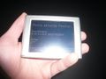
GPS
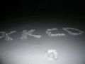
the internet was here
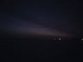
first glint of the morning, which is still a while away


I wonder for how much longer Scott will stay in hibernation.