Difference between revisions of "2010-01-17 48 2"
imported>Rwh (Created page) |
imported>FippeBot m (Location) |
||
| (11 intermediate revisions by 3 users not shown) | |||
| Line 1: | Line 1: | ||
| − | |||
| − | |||
| − | |||
| − | |||
| − | |||
| − | |||
| − | |||
{{meetup graticule | {{meetup graticule | ||
| − | | lat= | + | | lat=48 |
| − | | lon= | + | | lon=2 |
| − | | date= | + | | date=2010-01-17 |
}} | }} | ||
| Line 15: | Line 8: | ||
__NOTOC__ | __NOTOC__ | ||
== Location == | == Location == | ||
| − | + | In the middle of a paddock near the small town of Tousson, in the Parisian graticule, Île-de-France, France. | |
== Participants == | == Participants == | ||
| − | + | [[User:Rwh|Rwh]] | |
== Plans == | == Plans == | ||
| Line 24: | Line 17: | ||
== Expedition == | == Expedition == | ||
| + | My first geohash! Used the iPhone app to find the nearest one and noticed it wasn't in the middle of anyone's back yard. Nice and close to the beautiful Fontainebleau area too, so I could go for a walk in the forest afterwards. Jumped on the motorbike for a trip of about 90km, with my camera on the front set to timelapse (will link to the video when I've processed it). | ||
| + | Managed to make it almost all the way there uneventfully, but took a wrong turn right at the end, ending up next to a cemetery. Thankfully, there was a rural dirt road, about 100m long, running between the road I was on and the one I wanted to be on. "Shortcut!" I thought, inwardly delighting in the opportunity to give my motorbike another test of its off-road capabilities (a Honda Varadero XL125, said to be not inconsiderable). However, being the middle of winter in France, and being an exceptionally clayey area, the top surface of said dirt road was greasy, slippery, soft clay, which promptly wrapped itself around my front wheel, jamming under the mudguard and preventing it from rotating; I hit the deck. (this bit is particularly worth watching in the video). At least the soft clay prevented any damage to the bike. | ||
| − | + | After managing to right the heavy bike, struggling to get it out of the ditch that I'd ended up in, and digging all the clay out from under the mudguard with a stick (something the passing rural types out walking their dogs found pretty entertaining), I popped around the last kilometre or so to the closest point on the road, had some lunch and walked the remaining 150m or so to the point. | |
== Photos == | == Photos == | ||
| − | |||
<gallery perrow="4"> | <gallery perrow="4"> | ||
| − | Image: | + | Image:2010_01_17_48_2_motorbike.jpg | My transport. Mud on the side is due to a fall earlier when I was trying to take a "shortcut" on a sloppy-clay topped rural track. |
| − | Image: | + | Image:2010_01_17_48_2_paddock.jpg | The paddock that contains the point, also with heaps of soft clay that just loooved sticking to one's boots. |
| + | Image:2010_01_17_48_2_GPS.jpg | Made it! | ||
| + | Image:2010_01_17_48_2_fontainebleau.jpg | And a quick walk in the forest afterwards. | ||
</gallery> | </gallery> | ||
| − | |||
| − | |||
| − | |||
| − | |||
| − | |||
| − | |||
| − | |||
| − | |||
| − | |||
| − | |||
[[Category:Expeditions]] | [[Category:Expeditions]] | ||
| − | |||
[[Category:Expeditions with photos]] | [[Category:Expeditions with photos]] | ||
| − | |||
| − | |||
| − | |||
| − | |||
| − | |||
[[Category:Coordinates reached]] | [[Category:Coordinates reached]] | ||
| − | + | {{location|FR|77}} | |
| − | |||
| − | |||
| − | |||
| − | |||
| − | |||
| − | |||
| − | |||
| − | |||
| − | |||
Latest revision as of 00:31, 9 August 2019
| Sun 17 Jan 2010 in 48,2: 48.3269580, 2.4644099 geohashing.info google osm bing/os kml crox |
Location
In the middle of a paddock near the small town of Tousson, in the Parisian graticule, Île-de-France, France.
Participants
Plans
Expedition
My first geohash! Used the iPhone app to find the nearest one and noticed it wasn't in the middle of anyone's back yard. Nice and close to the beautiful Fontainebleau area too, so I could go for a walk in the forest afterwards. Jumped on the motorbike for a trip of about 90km, with my camera on the front set to timelapse (will link to the video when I've processed it).
Managed to make it almost all the way there uneventfully, but took a wrong turn right at the end, ending up next to a cemetery. Thankfully, there was a rural dirt road, about 100m long, running between the road I was on and the one I wanted to be on. "Shortcut!" I thought, inwardly delighting in the opportunity to give my motorbike another test of its off-road capabilities (a Honda Varadero XL125, said to be not inconsiderable). However, being the middle of winter in France, and being an exceptionally clayey area, the top surface of said dirt road was greasy, slippery, soft clay, which promptly wrapped itself around my front wheel, jamming under the mudguard and preventing it from rotating; I hit the deck. (this bit is particularly worth watching in the video). At least the soft clay prevented any damage to the bike.
After managing to right the heavy bike, struggling to get it out of the ditch that I'd ended up in, and digging all the clay out from under the mudguard with a stick (something the passing rural types out walking their dogs found pretty entertaining), I popped around the last kilometre or so to the closest point on the road, had some lunch and walked the remaining 150m or so to the point.
Photos
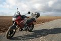
My transport. Mud on the side is due to a fall earlier when I was trying to take a "shortcut" on a sloppy-clay topped rural track.
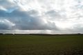
The paddock that contains the point, also with heaps of soft clay that just loooved sticking to one's boots.
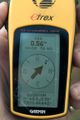
Made it!
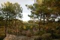
And a quick walk in the forest afterwards.


