Difference between revisions of "2010-01-22 42 -89"
imported>Mrmoses (added pictures) |
imported>FippeBot m (Location) |
||
| (18 intermediate revisions by 6 users not shown) | |||
| Line 1: | Line 1: | ||
| − | |||
| − | |||
| − | |||
| − | |||
| − | |||
| − | |||
{{meetup graticule | {{meetup graticule | ||
| lat=42 | | lat=42 | ||
| lon=-89 | | lon=-89 | ||
| date=2010-01-22 | | date=2010-01-22 | ||
| + | | retro=1 | ||
}} | }} | ||
| − | + | ||
| − | |||
== Location == | == Location == | ||
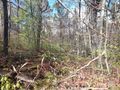
In the corner of a corn field. | In the corner of a corn field. | ||
| Line 32: | Line 26: | ||
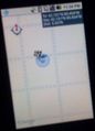
We were using our phones for navigation but kept loosing service. The GPS seemed to work, but there was no map data (as you can see in the images). | We were using our phones for navigation but kept loosing service. The GPS seemed to work, but there was no map data (as you can see in the images). | ||
| − | After taking some | + | After taking some fun-less gravel roads we eventually made it to field where the hashpoint was. We parked on the side of the road near an opening in the fence, put on the blinkers, and started walking. It was dark and foggy and the only light we had was from our phones, which was tricky because we also used our phones for navigation. So I kept pointing my phone down to see where I was walking (through snow and rows of dead and broken corn stalks). Then had to stop and look at my phone to see where I was, then point my phone down again to continue walking. |
| − | I don't think we stopped right on the hashpoint, but I'm sure we crossed it a few times. The combination of | + | I don't think we stopped right on the hashpoint, but I'm sure we crossed it a few times. The combination of losing service and not being able to see where we were going made it hard (and fun!), so we took some pictures and left. |
Also, this was all on Saturday night (not Friday). We didn't realize we went to Friday's hashpoint until recording our expedition on Monday morning (we are still working out the kinks in our geohashing skills). | Also, this was all on Saturday night (not Friday). We didn't realize we went to Friday's hashpoint until recording our expedition on Monday morning (we are still working out the kinks in our geohashing skills). | ||
| Line 43: | Line 37: | ||
Image:2010-01-22_foggydriving.jpg | Driving on a gravel road in the late night fog | Image:2010-01-22_foggydriving.jpg | Driving on a gravel road in the late night fog | ||
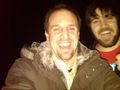
Image:2010-01-22_athashpoint.jpg | at the hashpoint | Image:2010-01-22_athashpoint.jpg | at the hashpoint | ||
| + | Image:2010-01-22_42_-89_at_first_hash.jpg | excited for our first geohash! | ||
| + | Image:hashpoint.jpg | And we made it! | ||
| + | Image:tempandtime.JPG | cold and late on our first geohash! | ||
</gallery> | </gallery> | ||
| − | + | ==[http://www.youtube.com/watch?v=2nmMUXjPLgM Video]== | |
| − | |||
| − | |||
| − | |||
| − | |||
| − | |||
| + | == Potential Life Lessons == | ||
| + | * Bring (at least) one flashlight. (But isn't it more fun without one?) | ||
| + | * Double-check if the coordinates are for the correct day. | ||
| − | [[ | + | == Achievements == |
| + | {{Blinded by Science | latitude = 42 | longitude = -89 | date = 2010-01-22 | reason = by using the wrong date | name = [[User:mrmoses|MrMoses]] and [[User:dleininger|DLeininger]] }} | ||
| + | {{gratuitous ribbon | ||
| + | | color = grey | ||
| + | | icon = Thumbsup.png | ||
| + | | latitude = 42 | longitude = -89 | date = 2010-01-22 | ||
| + | | achievement = [[Gratuitous ribbon achievement|Foggy Geohash Gratuitous Retro Achievement]] | ||
| + | | description = traveling through fog to reach the retro | ||
| + | | name = [[User:mrmoses|MrMoses]] and [[User:dleininger|DLeininger]] | ||
| + | | image = 2010-01-22_foggydriving.jpg | ||
| + | }} | ||
| + | {{gratuitous ribbon | ||
| + | | color = black | ||
| + | | icon = Midnightgeohash.png | ||
| + | | latitude = 42 | longitude = -89 | date = 2010-01-22 | ||
| + | | achievement = [[Gratuitous ribbon achievement|Nocturnal Geohash Gratuitous Retro Achievement]] | ||
| + | | description = traveling flashlightless at night to reach the retro | ||
| + | | name = [[User:mrmoses|MrMoses]] and [[User:dleininger|DLeininger]] | ||
| + | | image = 2010-01-22_42_-89_at_first_hash.jpg | ||
| + | }} | ||
| − | [[Category: | + | [[Category:Retro coordinates reached]] |
| − | |||
[[Category:Expeditions with photos]] | [[Category:Expeditions with photos]] | ||
[[Category:Expeditions with videos]] | [[Category:Expeditions with videos]] | ||
| − | + | {{location|US|IL|OG}} | |
| − | |||
| − | |||
| − | |||
| − | |||
| − | |||
| − | |||
| − | |||
| − | |||
| − | |||
Latest revision as of 00:34, 9 August 2019
| Fri 22 Jan 2010 in 42,-89: 42.1509071, -89.4540366 geohashing.info google osm bing/os kml crox |
Contents
Location
In the corner of a corn field.
Participants
Plans
Become real geohashers and get to our first hashpoint!
We were hanging out at a friends house that was only about 12 miles north of the hashpoint. We planned on swinging by the hashpoint on our way home (driving to the nearest intersecting roads and walking out into the field).
Expedition
It was a cold and foggy night (really foggy). We left at 11pm, excited for our first geohash expedition.
I think we averaged 30mph off the highway because it was so foggy. On the way to the hashpoint, we almost hit a raccoon, and then we did hit an opossum (but we did try to miss it). On the way back we almost hit a raccoon (we think it was the same one).
We were using our phones for navigation but kept loosing service. The GPS seemed to work, but there was no map data (as you can see in the images).
After taking some fun-less gravel roads we eventually made it to field where the hashpoint was. We parked on the side of the road near an opening in the fence, put on the blinkers, and started walking. It was dark and foggy and the only light we had was from our phones, which was tricky because we also used our phones for navigation. So I kept pointing my phone down to see where I was walking (through snow and rows of dead and broken corn stalks). Then had to stop and look at my phone to see where I was, then point my phone down again to continue walking.
I don't think we stopped right on the hashpoint, but I'm sure we crossed it a few times. The combination of losing service and not being able to see where we were going made it hard (and fun!), so we took some pictures and left.
Also, this was all on Saturday night (not Friday). We didn't realize we went to Friday's hashpoint until recording our expedition on Monday morning (we are still working out the kinks in our geohashing skills).
Photos
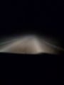
Driving on a gravel road in the late night fog
at the hashpoint
excited for our first geohash!
And we made it!
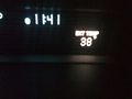
cold and late on our first geohash!


Video
Potential Life Lessons
- Bring (at least) one flashlight. (But isn't it more fun without one?)
- Double-check if the coordinates are for the correct day.
Achievements
MrMoses and DLeininger earned the Blinded by Science Consolation Prize
|
MrMoses and DLeininger earned the Foggy Geohash Gratuitous Retro Achievement
|
MrMoses and DLeininger earned the Nocturnal Geohash Gratuitous Retro Achievement
|