Difference between revisions of "2010-01-23 40 -74"
imported>Jevanyn (+cat) |
imported>FippeBot m (Location) |
||
| (4 intermediate revisions by one other user not shown) | |||
| Line 35: | Line 35: | ||
== Photos == | == Photos == | ||
| − | + | <gallery perrow="3"> | |
| − | + | Image:2010-01-23 40 -74 1054.JPG|Evan's kind of adventure! | |
| − | + | Image:2010-01-23 40 -74 1048.JPG|Easily distracted by the jungle gym. (And so was Evan.) | |
| − | + | Image:2010-01-23 40 -74 1103.JPG|Taking a swing on the swing. | |
| − | Image: | + | Image:2010-01-23 40 -74 1086.JPG|Doing the GPS dance. |
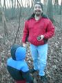
| − | Image: | + | Image:2010-01-23 40 -74 1083.JPG|Picture of the GPS within a few feet of the geohash. Whaddya mean, you can't read it? |
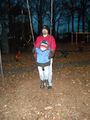
| + | Image:2010-01-23 40 -74 1079.JPG|Evan had the line of the day: "We drove all the way here for ''this?!''" | ||
| + | Image:2010-01-23 40 -74 1110.JPG|View of Manhattan from just around the corner. It's hard to take a steady picture when you're shivering. | ||
</gallery> | </gallery> | ||
| − | |||
| Line 48: | Line 49: | ||
[[Category:Expeditions with photos]] | [[Category:Expeditions with photos]] | ||
[[Category:Coordinates reached]] | [[Category:Coordinates reached]] | ||
| − | [[Category:Jevanyn | + | [[Category:Jevanyn/brought Gwynnath]] |
| + | [[Category:Jevanyn/brought Evan]] | ||
| + | {{location|US|NJ|HD}} | ||
Latest revision as of 00:36, 9 August 2019
| Sat 23 Jan 2010 in 40,-74: 40.7999679, -74.0504074 geohashing.info google osm bing/os kml crox |
Location
Schmidt's Woods Park, Secaucus.
Participants
- Jevanyn
- Gwynnath
- Evan
Plans
I checked the location Friday morning and discovered that it was in a park. A great location for a big meetup! Unfortunately, it was cold, so it was just the three of us.
Expedition
It's a little tricky to get into the local streets in Secaucus, so I did a lot of backtracking and criss-crossing before getting to the park. The park itself was nice, with a playground and lots of benches and barbecue stands. It wasn't very large though, maybe a quarter mile between opposite corners.
Trusting the GPS makes a big difference in locating a hash. I took a different approach, and didn't print out directions to the park, just followed the map on the Motorola Q, and the waypoint pointer on the Garmin. It was exciting to watch the distance count down from 530 ft in the parking lot, to 70 ft at closest approach on an exercise track through the park, then 15 ft. I did the GPS dance in a small clearing, trying to get the distance to go to zero. When it finally did, Gwynnath and I cheered. Evan said, and I'm not making this up, "We came all this way to go here?!?"
We pushed him on the swings for a few minutes until it started getting really dark, then went to dinner in Mill Creek Mall.
Tracklog
Um, yeah, I have one. I need to get the PC and the GPS to talk to each other.
Photos

Evan's kind of adventure!
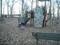
Easily distracted by the jungle gym. (And so was Evan.)
Taking a swing on the swing.
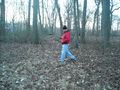
Doing the GPS dance.
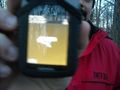
Picture of the GPS within a few feet of the geohash. Whaddya mean, you can't read it?
Evan had the line of the day: "We drove all the way here for this?!"
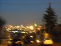
View of Manhattan from just around the corner. It's hard to take a steady picture when you're shivering.


