Difference between revisions of "2010-01-28 42 -89"
imported>Mrmoses (added tracklog and photo) |
imported>FippeBot m (Location) |
||
| (9 intermediate revisions by 3 users not shown) | |||
| Line 1: | Line 1: | ||
| − | |||
| − | |||
| − | |||
| − | |||
| − | |||
{{meetup graticule | {{meetup graticule | ||
| lat=42 | | lat=42 | ||
| Line 31: | Line 26: | ||
We knew the hashpoint was somewhat close to a house, so we debated approaching the house and asking for permission to go in the field vs. just running out into the field from the road. When we got closer we realized the field was fenced off so we decided to go to the house and ask. The lady said "yea, that's fine". | We knew the hashpoint was somewhat close to a house, so we debated approaching the house and asking for permission to go in the field vs. just running out into the field from the road. When we got closer we realized the field was fenced off so we decided to go to the house and ask. The lady said "yea, that's fine". | ||
| − | It was so cold that the snow was frozen hard enough to walk on top of it without sinking in | + | It was so cold that the snow was frozen hard enough to walk on top of it without sinking in. We didn't have a flashlight again, but it was a full moon so it was pretty easy to see and navigate through the rows of stubby corn stalks. We were trying to hurry 1) because of the cold and 2) my phone was still dying. |
We got to the hashpoint and started taking screenshots and stuff on our phones. Using touch screen phones we had to take our gloves off, which made our hands go numb pretty quickly, so we hurried up and went back to the car forgetting to actually take pictures of ourselves at the hashpoint. | We got to the hashpoint and started taking screenshots and stuff on our phones. Using touch screen phones we had to take our gloves off, which made our hands go numb pretty quickly, so we hurried up and went back to the car forgetting to actually take pictures of ourselves at the hashpoint. | ||
| Line 37: | Line 32: | ||
All in all, another successful geohash! | All in all, another successful geohash! | ||
| − | == Tracklog == | + | == [http://maps.google.com/maps/ms?ie=UTF8&hl=en&msa=0&msid=109316342448012701002.00047e457be301e91c37e&t=h&z=12 Tracklog]== |
| − | [http://maps.google.com/maps/ms?ie=UTF8&hl=en&msa=0&msid=109316342448012701002.00047e457be301e91c37e&t=h&z=12 | + | Here is a screenshot of the tracklog in the field. Click to view the full track log. |
| + | [[File:2010-01-28 42 -89 My Tracks.png|left|650px|link=http://maps.google.com/maps/ms?ie=UTF8&hl=en&msa=0&msid=109316342448012701002.00047e457be301e91c37e&t=h&z=12]] | ||
| + | <br style="clear: both;" /> | ||
| + | |||
| + | |||
== Photos == | == Photos == | ||
<gallery perrow="4"> | <gallery perrow="4"> | ||
| − | Image:2010-01- | + | Image:2010-01-28_42_-89-farmhouse.jpg|Farm House we went to... |
| + | Image:Hashpoint photo.jpg|Hashpoint! | ||
| + | Image:Cheaper_gps.PNG|iPhone Cheaper GPS screenshot "ARRIVED!" | ||
Image:2010-01-28 42 -89 hashpoint screenshot.jpg|screenshot at the hashpoint | Image:2010-01-28 42 -89 hashpoint screenshot.jpg|screenshot at the hashpoint | ||
| + | Image:Screen_shot_hashpoint.PNG|Here's another screenshot | ||
| + | Image:Temp.PNG |it was freaking cold... | ||
</gallery> | </gallery> | ||
| − | + | ==[http://www.youtube.com/watch?v=JAsQbcwkxkg&feature=player_embedded Video]== | |
| − | [[ | + | |
| + | == Achievements== | ||
| + | {{land geohash | latitude = 42 | longitude = -89 | date = 2010-01-28 | name = [[User:mrmoses|MrMoses]] and [[User:dleininger|DLeininger]] }} | ||
| + | {{gratuitous ribbon | ||
| + | | color = black | ||
| + | | icon = Midnightgeohash.png | ||
| + | | latitude = 42 | longitude = -89 | date = 2010-01-28 | ||
| + | | achievement = [[Gratuitous ribbon achievement|Nocturnal Geohash Achievement]] | ||
| + | | description = traveling flashlightless at night to reach the | ||
| + | | name = [[User:mrmoses|MrMoses]] and [[User:dleininger|DLeininger]] | ||
| + | }} | ||
| + | |||
[[Category:Expeditions]] | [[Category:Expeditions]] | ||
| Line 53: | Line 67: | ||
[[Category:Expeditions with videos]] | [[Category:Expeditions with videos]] | ||
[[Category:Coordinates reached]] | [[Category:Coordinates reached]] | ||
| + | {{location|US|IL|WN}} | ||
Latest revision as of 00:37, 9 August 2019
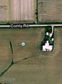
| Thu 28 Jan 2010 in Rockford, IL: 42.2745448, -89.3064383 geohashing.info google osm bing/os kml crox |
Location
Just another corn field.
Participants
Plans
MrMoses and DLeininger are going to Pecatonica this evening (after work), and eventually will be going back to Rockford, so we will be passing this hashpoint twice. We will prolly stop by the hashpoint on the way back to Rockford (which will be later in the evening between 7-10pm).
We will prolly stop at the farmers house and ask if we can wander in the field (without fear of getting shot at or having dogs chase us).
Expedition
We left Pecatonica heading for the haspoint around 7pm. It was cold, dark, and more cold. I use the Geohash Droid app on my phone for navigating to the hashpoint, but my phone was about to die because I had been downloading and testing out GPS tracking apps all day. Luckily I had a charger in DLeininger's car, so I plugged it in, fired up the My Tracks app and Geohash Droid and we headed to the hashpoint.
We knew the hashpoint was somewhat close to a house, so we debated approaching the house and asking for permission to go in the field vs. just running out into the field from the road. When we got closer we realized the field was fenced off so we decided to go to the house and ask. The lady said "yea, that's fine".
It was so cold that the snow was frozen hard enough to walk on top of it without sinking in. We didn't have a flashlight again, but it was a full moon so it was pretty easy to see and navigate through the rows of stubby corn stalks. We were trying to hurry 1) because of the cold and 2) my phone was still dying.
We got to the hashpoint and started taking screenshots and stuff on our phones. Using touch screen phones we had to take our gloves off, which made our hands go numb pretty quickly, so we hurried up and went back to the car forgetting to actually take pictures of ourselves at the hashpoint.
All in all, another successful geohash!
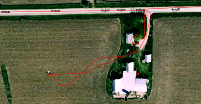
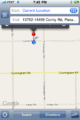
Tracklog
Here is a screenshot of the tracklog in the field. Click to view the full track log.
Photos
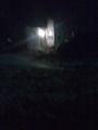
Farm House we went to...
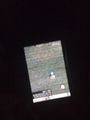
Hashpoint!
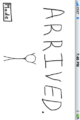
iPhone Cheaper GPS screenshot "ARRIVED!"
screenshot at the hashpoint
Here's another screenshot
it was freaking cold...


Video
Achievements
MrMoses and DLeininger earned the Land geohash achievement
|
MrMoses and DLeininger earned the Nocturnal Geohash Achievement
|